http://www.defense.gov/DODCMSShare/briefingslide/185/011011-D-6570C-008.jpg
http://www.defense.gov/DODCMSShare/briefingslide/185/011011-D-6570C-009.jpg
 And
aftr:
And
aftr: 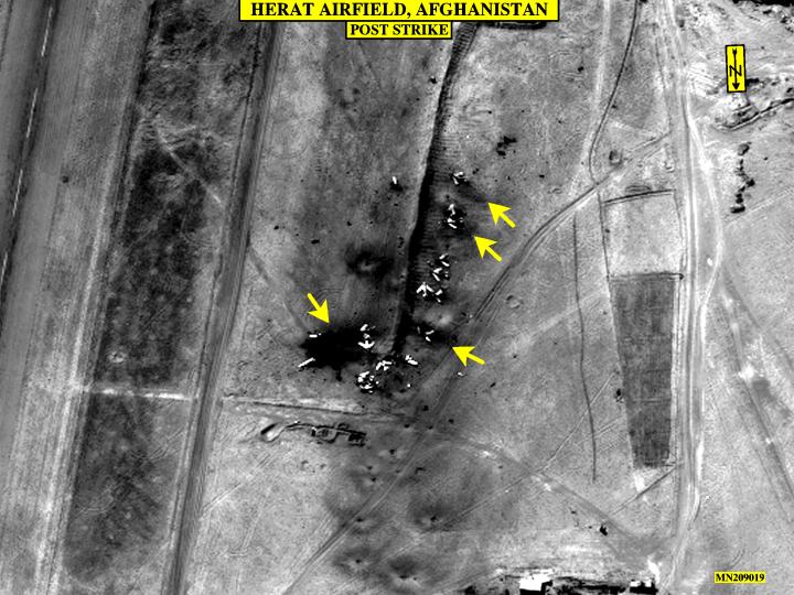
9/11/02
Lecture notes on Global Positioning Satellite (GPS):
Visit the trimble website. Trimble is a leading supplier of GPS equipment; its website has a good tutorial, from which many of these notes are taken... an ex-student of mine, Tom Myers, class of '82, worked for Trimble, on their "remote control tractor" project.
May 2011 Update: Osama bin Laden killed:
http://www.nytimes.com/interactive/2011/05/02/world/asia/abbottabad-map-of-where-osama-bin-laden-was-killed.html?scp=2&sq=May%202011%20Osama%20bin%20Laden%20killed&st=cse
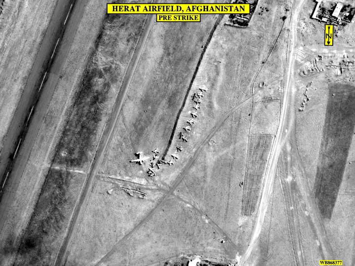
Suppose satellite photos have allowed the Air Force to pinpoint the longitudes
and lattitudes of MIG fighter jets on the runway of the Herat airport (in western
Afghanistan). The GPS signals (being processed at a classified sample rate)
in a cruise missile (a Tomahawk, fired from a Navy ship or submarine 600 hundred
miles south in the Arabian Sea; the missile flies close to the ground) headed
to Herat, can be compared to the Herat runway coordinates. Negative feedback
can adjust the 3-D trajectory of the missile and pinpoint it directly to a MIG
on the runway. Poof. "After" reconnaissance photos will show a set
of splotches on the runway, where each MIG used to be. Related websites are,
from Oct 2001,
http://www.defense.gov/DODCMSShare/briefingslide/185/011011-D-6570C-008.jpg
http://www.defense.gov/DODCMSShare/briefingslide/185/011011-D-6570C-009.jpg
And
aftr:
and from the How Stuff Works website, more on cruise missiles:
http://science.howstuffworks.com/cruise-missile1.htm
GPS is not one satellite, but 24. The 24 satellites surround the earth, such that any point on or a little above the surface of the earth has a "view" of at least 5 GPS satellites. The satellites are in geosynchonous orbit at an altitude of about 11,000 miles. GPS was built (sent into orbit?) by the Defense Dept., at a cost of about 12B$ (500M$/satellite...). In addition to the satellites themselves, DOD maintains various ground stations to uplink data to the satellites.
GPS offers a way for a properly equipped receiver to pinpoint its position on or a few miles above the surface of the earth. The receiver needs "see" enough GPS satellites for a valid calculation; a receiver in B&H 095 probably wouldn't work because too much building structure blocks satellite transmissions.
How accurate is GPS? One the one hand, that is classified information, on the other hand I can tell you that GPS receivers are mounted on opposing sides of the San Andreas fault in California, and can report changes across the fault to within millimeters.
A Cesium Atomic Clock is aboard each of the GPS satellites. Such atomic clocks are rather complex, but boil down to dependence on the the oscillation frequency of a cesium atom as it moves between two energy states. A second is now defined as 9,192,631,770 cycles of radiation from such a cesium atom. The best atomic clocks (NIST-F1) are good for less than 0.1 nanosecond per day deviation. To buy a such a cesium atomic clock would cost you about $200,000.
For reference, the speed of light can be remembered as about 1 ft/nsec. A GPS receiver, such as the kind you can buy from LL Bean for a few hundred $$, comes to know its longitude and latitude by triangulating signals from at least 3 satellites, to within several meters.
Basically a receiver figures out how far it is from each of 3 satellites and computes exactly what point in space matches that set of data. Yes, the receiver has to know the location in space of each of the 3 satellites, and that information is contained in the "signature" (pseudo-random sequence, PRS) pulse code sent down by each satellite. And in fact, if you think about it, the calculation will result in two mirror image solutions to where the receiver might be, so a further assumption about where the surface of the earth is must be used to pick which solution is correct. "Quadrangulating" with a 4th satellite could also tell what the correct location is...
The positions of the 24 satellites are monitored by ground-based radar and other (optical) methods of triangulating position. Ground-based transmissions relay a satellite's position back up to it...
How can the receiver tell the distance to a satellite? Distance = velocity X time. The receiver knows when the pulse arrived...when did it start? Because of synchronized atomic clocks, a satellite can be sending out PRS pulses at precise time intervals. What about the receiver? in one millisecond light travels about 200 miles...
Here's where the 4th satellite comes in... Best to consider the 2-D problem: (or see See Trimble tutorial for well drawn 3-D diagrams). The receiver can guess when the satellite transmissions were sent and use that guess to calculate an intersection of lengths from the 2 satellites. If a 3rd (in 2-D) satellite source doesn't intersect the first "answer", the receiver applies correction factors to the time delays until it does, and thus the receiver becomes as accurate as an atomic clock for the purpose of position location. The receiver looks for a single correction that it can add or subtract from all its measurements to make the extra satellite agree with the first (2 satellites) calculation.
Even simpler than 2D: one-D! Say the speed of transmission is 1unit/sec. Say the first satellite is really 10 units away on the x-axis, at x = -10. Say also that it's information is transmitted at 1 unit-distance/sec. A guess-timate about the transmission time of 9 seconds ago puts the receiver location 9 units away at -1. On the other side, also 10 units away at x = +10, is another satellite. The transmission time guess of 9 seconds ago puts the receiver at +1. The two positions don't match, but do if the transmission time is reset to 10 seconds ago. It would have been the case that your on-board clock was 1 second slower than the accurate clocks in the transmitters.
Now, how does the receiver know the locations of the satellites in question? DOD
monitors the satellites with radar, from the ground stations, and compares its results
to math programs that are calculating trajectories in orbit. The radar readings
can account for "ephemeris" errors due to gravitational pulls of the Moon
and the Sun. DOD uploads the position as a function of time information to the satellites,
which include their position information in the broadcasts they send to earth.
Correcting the speed of light in the atmosphere. The speed of light in a
vacuum is constant, but in the atmosphere it's slowed down slightly, as it is when
passing through glass or other transparent matter, to allow calculation of index
of refraction. Also the relative humidity of the atmosphere can affect the speed
of light.
<Other factors: "Geometric Dilution of Precision" from satellites too close together.>
Correcting errors with Differential GPS: Say a second receiver, nearby on earth, is a stationary reference; it may even contain an expensive atomic clock... The primary receiver can be the GPS on your moving boat, away at sea. The idea: two receivers that are within a few hundred miles of each other are looking at signals that have the same atmospheric and satellite errors. Because the position of the reference is known, it can correct for all errors and send out corrections to all GPS within range. Even the deliberate DOD signal+noise degradation can be corrected with known references! The reference receiver works back from its known position to correct the timing signals, then sends that "reverse engineering" information to local roving receivers. The reference receiver sends out corrections for all satellites within view, to all roving receivers using any of the satellites. Many reference locations are now broadcasting, especially along coastlines, where the Coast Guard has installed them.
Other issues: can the receiver look at the signal, or does it have to lock on to
a carrier frequency? The signal is about 1MHz, the carrier frequency is about 1GHz
( 1000x higher freq). Carrier frequency locking can achieve 3-4 mm accuracy. whew.