|
|
|
|
|
 |
|
|
|
Mapping the Traveled Space:
Hans Staden’s Maps in Warhaftige Historia
Alida C. Metcalf
Department of History
Rice University
[email protected]
Abstract
By examining the map and map-like illustrations published in Hans Staden’s Warhaftige Historia (1557), this article argues that the maps underscore the truthfulness of the narrator by reinforcing his role as an eyewitness observer. Beyond bolstering the narrator’s authority, Staden’s map projects a distinctly different image of Brazil. The mapping tradition of mariners seems to have been a major influence, and the map accords ownership of the mainland to indigenous groups, making his a unique representation of sixteenth-century Brazil.
Keywords
Sixteenth-Century, Brazil, eyewitness observer, Hans Staden, mapping
Resumo
Com base nas ilustrações publicadas por Hans Staden na obra Warhaftige Historia de 1557, argumenta-se neste artigo que os mapas conferem ênfase à visão do narrador, uma vez que reforçam o seu papel enquanto testemunha da realidade observada. Para além de reforçar a autoridade do narrador, o mapa de Hans Staden projecta uma imagem diferente do Brasil. A tradição de mapeamento dos marinheiros parece ter exercido uma grande influência, uma vez que o mapa atribui a posse do território a grupos indígenas, tornando esta representação cartográfica do Brasil no século XVI especialmente significativa.
Palavras-chave
século XVI, Brasil, observação, Hans Staden, cartografia
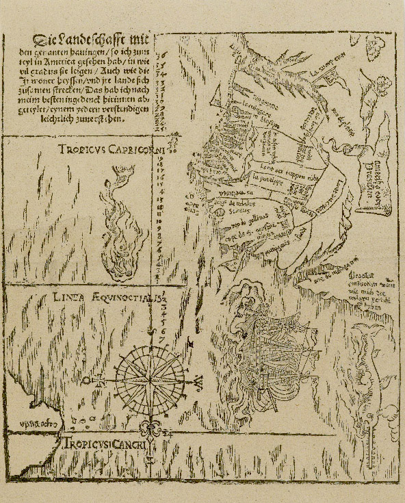
What is the value of the traveler’s map? Hans Staden’s Warhaftige Historia (1557), one of the most famous accounts of Brazil published in the sixteenth century, is introduced visually by a fold-out, woodcut map (fig. 1). As the narrative unfolds, Staden recreates his sea voyages and two sojourns in Brazil through text and images, some of which serve as geographic, map-like representations. Because of the vivid and explicit depictions of cannibalism in his text and illustrations, Staden has been dismissed and his motives questioned (Ahrens 1979; Menninger: 1995). Because it is a travel account, literary scholars argue that it belongs within that genre, which is known for the recurring myths, concepts, and projections originating in ancient and medieval European times that are used to explain unfamiliar peoples (Klarer 1999; Mancall 2006: 12; 256-263). Other studies of Staden, however, have argued that the context of his travel can be corroborated (Franco 1942), that the text is “indispensable” for understanding sixteenth-century Brazil (Whitehead 2000: 724), that its descriptions of cannibalism should not be rejected out of hand (Forsyth 1985), and that the text and illustrations are illuminating when examined from multiple perspectives (Obermeier and Schiffner 2008). In particular, Staden’s immersion among the Tupinambá differentiates his ethnographic description from that of Jesuits or outside observers, such as Jean de Léry or André Thevet (Whitehead 2008: xv-civ); his identification with the mixed-race mamelucos (Villas Boas 2005), his performance as a “practiced chameleon” (Martel 2006: 58), and his agency as a go-between (Metcalf 2008) all suggest that his is a unique perspective. This article examines Staden’s map and map-like illustrations and argues that while they serve to underscore Staden’s authority as an observer and intensify his religious message, they are nevertheless significant as eyewitness geographic representations of Brazil.
On the surface, the answer to the first question, on the value of a traveler’s map, seems obvious. Unlike the cartographer who has been trained to represent the world, to work with projection, scale, and verified geographic information, the traveler is a naïve observer. Not only are travelers not mapmakers, but they have been known to be unreliable. Yet in fifteenth and sixteenth-century Europe, as the classical views of the world were being undermined by sea voyages mounted by the Portuguese and others interested in trade and colonies, the traveler might well offer pertinent observations and contribute to an emerging new perspective of the world. Still, if we compare Staden’s map of Brazil with the “professional” mapping done by Portuguese, Spanish, and French cartographers (see Alegria et al 2007: 1029-1032) his is clearly a crude, modest sketch.
Staden’s map is oriented with south at the top. It features a Portuguese-style compass rose of 32 points with a fleur-de-lis marking north and a cross pointing east placed below the Tropic of Cancer. The Tropics of Cancer and Capricorn, as well as the Equator, are labeled in Latin. Drawn through the compass rose is a prime meridian, shown to be some distance west of Cape Verde. The degrees of latitude from 7º N to 36° S are clearly marked. Place names are written at right angles to the coastline. Two flags indicate the northern and southern limits of the Portuguese claim, while a Spanish [Castilian] flag marks Asunción. Two sea creatures and a ship are the major artistic embellishments to the map, but some care has been taken to render waves in the Atlantic, while mountains and clouds are suggestive of the deep interior of South America. The map’s legend in German reads:
The landscape with the named ports—
as I partially have seen them in America—
in the gradients in which they lie—
also as the inhabitants call them—
and how their lands are put together—
this I have tried to show to the best of my abilities—
something that each can easily understand.1
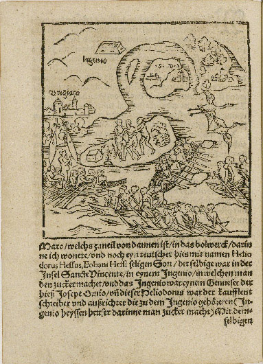
The woodcut illustrations of Warhaftige Historia, which appear to have been drawn by Staden and carved by a woodcutter, appear only in the first edition, and are an important component of his text, as Neil Whitehead and others have argued (Whitehead 2000: 723; Letts 1929: xvii-xx). In addition to the fold-out map, some of the woodcut illustrations have clear map-like features in that they depict scenes taking place along a recognizable coastline. For example, the map-like illustration of the Island of Santa Catarina where Staden’s ship anchored on his second trip to Brazil, stresses the shape of the harbor, the location of the island, and major geographical elements of the mainland (fig. 2). Some of the map-like illustrations suffer from a problem often found in printing: they appear inverted. An erratum to the Marburg edition notes that five woodcuts were accidentally turned around during the production of the blocks. One of the depictions of São Vicente, where Staden lived and worked as a gunner in Bertioga, a settlement on the northern frontier, appears inverted (fig. 3). The stone building that represents the fort at Bertioga is visible on the southern end of the island; it should appear on the northern shore as it does in fig. 4. The inclusion of this erratum suggests that Staden reviewed the text and insisted on correcting the errors; we may thus conclude that the illustrations were intended to be geographically accurate, to the best of his ability.
Why did Staden, who was neither an artist nor a cartographer, include maps in his text? Travelers often survived calamitous experiences in the sixteenth century, and Staden was no exception. Shipwrecks, attacks by pirates, starvation, and sickness were all dangers travelers faced (Brito 1998), and while ashore in distant lands the traveler confronted violence, uncertainty, and unfamiliarity. In telling their stories, words sometimes failed to describe what they had seen. The map, the sketch, and the illustration became a means of recording experience and communicating that which was impossible to fully express in words. Maps themselves were illustrated, and artists began to accompany sea voyages, becoming “painter-cartographers” in order to better capture what was being seen (Quinn 1986). The map and the sketch were accessible even to the illiterate or semi-literate; the sea chart, for example, had long been effectively used by only marginally literate pilots (Sandman 2001).
Maps enriched textual narratives, especially when unfamiliar places and their inhabitants were being described. They often accompanied the letters written to merchants. In 1500 Amerigo Vespucci promised Lorenzo di Pierfrancesco de’ Medici that “just as I have given you an account by letter…. I shall send you two depictions of the world, made and ordered by my own hand” (Vespucci 1992). Another famous example is Alberto Cantino, who wrote letters about the Portuguese discoveries in America and Asia to Hercole D’Este, the Duke of Ferrara, and later sent the striking, unsigned world map that is still known as “La Carta del Cantino” (Harisse 1893). As sixteenth-century voyages uncovered more unknown places, authors, such as Alonso de Santa Cruz (a Spanish mapmaker) or Antonio Pigafetta (who accompanied Magellan), described peoples, ways of life, flora, and fauna through text, images, and maps (Conley 2007: 405).
Staden rested his claim to authority on what he had seen, as is evident in his legend where he states: “The landscape with the named ports/as I partially have seen them in America.” In his assertion that his observations were reliable, Staden was like his shipmates who depended on observation and lived experience to survive at sea. Increasingly, eyewitness observation was recognized as fundamental for understanding the world, especially in Portugal and Spain where the observations recorded by sailors, pilots, and navigators both in written roteiros (directions for sea sailing) and nautical charts underlay successful sea voyages. Often this direct observation conflicted with the weight of authority, as enshrined in the study of classical authors at the university. Nevertheless, the direct observation of reality was imperative at sea and increasingly understood to be necessary for acquiring knowledge about the world (Domingues 2007).
Staden approached observed knowledge from a practical standpoint that reflected not only his military background but his association with sailors. Without focused observation duly recorded on sea charts and in sailing directions, men of the sea knew that it would be impossible to return to ports and to engage in trade. It did not necessarily matter that Staden was not trained as a navigator nor as a map-maker, for the tradition of making sea charts, or portolans, belonged to sailors, not to educated cosmographers. The portolan charts recorded the sailor’s direct experience of the sea and therefore reflected a vitality that came from constant revision (Campbell 1987). As Staden’s map legend reveals, he believed himself capable of representing the lands and ports that he had visited “in the gradients in which they lie.” He is confident that his observations can be verified by anyone who returns. As he concludes his text, anticipating that there will be those who will doubt his story, Staden recommends that he who does not believe him should go and see for himself: “then let him, with God’s help, undertake the voyage himself […]. I have given him information enough; let him follow the tracks” (Staden 2008, 145).
Staden’s map is intended to be simple, as he states clearly in the legend: “this I have tried to show to the best of my abilities/something that each can easily understand.” The simplicity of Staden’s map does not, however, relieve it of an undisclosed intention. As J. B. Harley argues, maps are value-laden images that are easily manipulated by the powerful (Harley 2001). No mapmaker can be an objective observer, for all maps exclude information; each map explicitly or implicitly favors the interests that lie behind the map (Wood 1992). In the case of sixteenth-century Brazil, Frank Lestringant demonstrates that maps by André Thevet or Guillaume Le Testu were fictions that created dreams of maritime empire for the French king (Lestringant 1988).
Staden’s map attests to the veracity of his account as do the woodcut illustrations that double as geographical sketches of places described in the text. Both the map and the geographic illustrations encourage the reader to locate Staden in specific places. These visual complements to the text underscore the main point made by Johannes Dryander, the humanist in Marburg who wrote the introduction to Staden’s narrative. Dryander insists that Staden is telling the truth. The map and the map-like illustrations work to convince the reader that this story cannot have been a fabrication. By allowing readers to visually comprehend the vastness of the American continent and to experience the customs of peoples living in local places, Staden made his travel account all the more accessible and all the more believable.
Moreover, Staden’s Warhaftige Historia is intended to be experienced as religious witnessing (TenHuisen 2005). The fold-out map and the map-like illustrations then take on a special role: with the map as a guide, and the geographical illustrations serving as scenes, the reader/viewer is enticed into the world to which Staden traveled. By accompanying Staden through the text and illustrations, the reader/viewer experiences the spiritual journey too. Staden is explicit about his reason for writing; his intention is:
to show how mightily our Lord and God, the helper in all Need, delivered me from their [the Tupinambá’s] power when I was without hope. Everyone shall know that Almighty God still protects and directs His faithful Christians among the godless heathen people in a most wondrous manner (Staden 2008: 143).
Even if the map and the geographic illustrations underscore Staden’s religious message, they nevertheless are of value to historians seeking to understand Brazil in the sixteenth-century. Just as Staden’s ethnographic descriptions are useful to anthropologists and ethnohistorians (Whitehead and Harbsmeier 2008: lxxxiv), so too is his mapping. Rather than serving the king, or projecting deep myths from medieval and ancient traditions onto Brazil, Staden’s maps reflect his more immediate immersion in the print culture of his German homeland, his exposure to the sea charts used by French, Spanish, and Portuguese sailors, and his personal experience in Brazil.
The form of Staden’s maps was clearly influenced by printed maps and landscape scenes that he undoubtedly had seen before he traveled to Brazil in 1547 and after he returned in 1555. The revolution in print had made the woodcut map and landscape illustration accessible to mass audiences in Germany through books, broadsides, and wall coverings. Editions of Ptolemy were printed in long runs—one edition ran about 1,000 copies (Campbell and Destombes 1987: 136). While Staden was clearly literate, we cannot be certain that he, given his occupation as a soldier, would have been proficient enough in Latin to have read or to have studied Ptolemy.
Printed maps intended for a middle-class audience, however, were readily available in Germany. The more modest prices for printed maps encouraged collecting by merchants, lawyers, scholars, and even tradesmen (Woodward 2007: 609). By 1500, each technical stage in the woodcutting done for printed maps was specialized. A cartographer drew the model, but the preparation of the image was done by specialized craftsmen (Grenacher 1970; Woodward 2007). In Strasbourg Johannes Grüninger became a highly successful publisher of maps in the early sixteenth century, printing nearly 100,000 large map sheets that could be assembled into large wall maps or viewed individually (Johnson 1963: 21). Although some scholars question the feasibility of pulling so many copies from one set of blocks, in 1516 Martin Waldseemüller refers to 1,000 copies having been printed of his previous wall map, presumably his magnificent world map of 1507 (Waldseemüller 2007).
Nuremberg was also a center of mapmaking (Meurer 2007: 1193-1198), and Staden would have been likely to see some of the first printed maps of Germany designed for travelers. The Romweg map by Erhard Etzlaub was printed in Nuremberg (c. 1500) and sold as a separate item, apparently for pilgrims making their way to Rome. The map was intended for the ordinary traveler, for it required no expertise in cartography to use, nor did it require the ability to read Latin. Printed on a single sheet, and in German, the map laid out for the traveler the way, mile by mile, to Rome (Englisch 1996: 106). The traveling map of Germany, the Landstrassen, similarly emphasized roads and distances (Campbell 1978; Schnelbögl 1966). The Etzlaub maps were oriented with south at the top of the map, as was Staden’s map of Brazil.
Staden’s map-like illustrations resemble woodcut prints of map-like landscapes printed in German books and as single sheets. The Nuremberg Chronicle, elaborately illustrated with more than 1,800 woodcuts, including maps of northern Europe and the world, and landscapes of cities, appeared in two large Latin and German editions in 1493 (Campbell 1987: 152). As a soldier, Staden was likely familiar with woodcut depictions of battle scenes. The Siege of Vienna, 1530, by Erhard Schoen, was a giant view of the city surrounded by the Turkish army accompanied by verses by Hans Sachs that further described many of scenes taking place (Strauss 1984: 443-446). The Siege of Muenster, printed in 1535, showed in sharp detail the German soldiers at war (Strauss 1984: 455-459). These battle images contained a schematic rendering of the terrain, depictions of events taking place, and were often accompanied by text. Staden would use all of these elements in his map-like illustrations.
As Christine Johnson (2008) notes, Germany was a center for Renaissance learning about European discoveries overseas, both in the Americas and Asia. The travel account became a common genre and maps and illustrations were often included. The enhancement added by maps is particularly evident in the account by Bernard von Breydenbach, the canon of the cathedral at Mainz, whose narration of his pilgrimage to Jerusalem was beautifully illustrated with fold-out woodcut maps (Breydenbach 1486). As the number of voyages increased, authors and editors began to illustrate travel accounts. Some of the illustrations were stock or recycled images, but others were drawn by artists who worked from peoples, animals, and artifacts brought back from overseas journeys (Johnson 2008: 32-37).
When Staden made his way home from Brazil in 1555, he had the opportunity to see and handle printed editions of books of travels, which often contained maps, or editions of atlases, and cosmographies. By his account, he passed through Antwerp en route to his home in Hesse and visited the exchange. At that time, booksellers had stalls at the entrance to the exchange where they sold their books (McCusker 2005). Several interesting books are known to have been published in the early 1550s in Antwerp that might have been for sale while Staden was in the city. These books include the Cosmographia of German mathematician Peter Apian (Petrus Apianus) that had an Antwerp edition of 1553 as did the chronicle of Peru by Pedro Cieza de León (1554) and Francisco López de Gómara’s history of Mexico (1554), which had a fold out map of the Americas appended to the end of the text.
Thus, not only was Staden likely to have seen many printed maps and to have been familiar with books enhanced by images and maps, but Johannes Dryander, who wrote the introduction to Warhaftige Historia, had published several books replete with illustrations and was also interested in cartography. One of Dryander’s books, the Annulorum (1537), a treatise on astronomical instruments, contained diagrams that showed how these instruments worked. His most famous books, such as Anatomiae (1537), emphasized the importance of dissection to medical knowledge and were accompanied with graphic depictions drawn from Dryander’s own work on human anatomy. Dryander also worked at mapping, for manuscripts in his hand served as models for printed maps of Hesse by Sebastian Münster and Abraham Ortelius (Meurer 2007: 1227 n. 346).
These German influences were profound, however, they account largely for the form and presentation of Staden’s maps. The content of Staden’s main map was undoubtedly informed by his exposure to nautical charts, especially those drawn by the Spanish, Portuguese, and French sailors with whom he sailed. These sea charts would have featured place names written at right angles to the coastline, compass roses, rhumb lines, a scale, flags marking possession of ports, a meridian bisected with degrees of latitude, and the lines of the Equator and the Tropics.
Atlantic sea charts used in the fifteenth and sixteenth century have largely all disappeared; the conditions at sea did not encourage the conservation of the well-used charts (Marques 1994: 38). Those charts that survived did so because they were highly decorated and therefore meant for a land-based patron; they were not to be taken to sea (Quinn 1986: 245). The extant Portuguese charts, maps, and atlases of Brazil drawn in the sixteenth century emphasize the exploration of the coast. Rivers, harbors, and settlements are carefully named while the mainland is decorated with drawings of birds and trees (La Carta del Cantino 1502) or representations of landscapes with indigenous peoples engaged in extractive activities (L’ Atlas Miller 1519).
French mapmakers are another likely influence on Staden. Staden returned from Brazil in 1555 on a French ship that hailed from Vatteville, a small village on the Seine, which was navigable by ocean-going ships all the way to Rouen, the largest and wealthiest city in the region, the hub of the French Atlantic trade, and the seat of the provincial and royal government in Normandy (Brunelle 1991: 9-10). Staden traveled to Dieppe before making his way to London and Antwerp. The distinctive cartographic style known as the Dieppe School emerged in seaport towns such as Dieppe and Honfleur in the sixteenth century. The French cartographers based their maps on Portuguese portolan charts. The Portuguese nomenclature is largely used, for example, and eyewitness depictions of peoples, animals, birds, and landscapes are emphasized over the recycling of imagined “fantastic” images (Wallis 1981; 1983).
Folio eleven in the 1547 Vallard Atlas from Dieppe is particularly interesting when compared to Staden’s map. The map is of South America and is oriented with south at the top of the map (as is Staden’s). The Equator and the Tropic of Capricorn are identified in French (Staden uses Latin) and place names are written in at right angles to the coastline, as was the style in portolan charts and Staden’s map. Far more place names appear in the Vallard folio than on Staden’s map, a fact that may be explained by Staden’s lack of access to sea charts in Marburg. Working from memory, and not being a pilot, Staden could recall only the most important names of coastal ports, landmarks, rivers, etc. Five compass roses and their intersecting rhumb lines are drawn on the Vallard folio whereas Staden’s map has one compass rose and no rhumb lines. Two ships decorate the ocean on the Vallard folio (one ship and two large fish appear on Staden’s).
The Vallard Atlas representation of the interior of Brazil shows carefully rendered scenes, such as of trade, village life, warfare, and the collection of Brazilwood. These are painted in color by a skilled artist. In contrast, Staden’s map divides up the interior of Brazil into lands belonging to indigenous groups. Staden attempts to demarcate boundaries between the indigenous groups whom he names. His drawing of lines thus conveys his perception of political power and control over territories that correspond with separate and autonomous indigenous nations.
Staden assigns ownership over and rights to territory to indigenous groups by writing “Land of the Tupinambá” or “Puttigaris Land” inside his boundaries. Along the coast, Staden’s use of names reflects the influence of the Spanish and Portuguese: “Rio de Maragnon” [Amazon River], “Cape de S. Agustim,” “Cape Frio,” “S. Vincente.” His spelling is a mixture of Spanish, French, and Portuguese. His placement of flags, which mark Spanish and Portuguese possessions, appear at “La Sumpcion” [Asunción] which flies a Spanish flag, and at the northern and southern limits of Portuguese influence: Marin [Olinda, Pernambuco] in the north and an unnamed place 28° S, between the mouth of the Rio de la Plata estuary and the island of São Vicente. In Staden’s rendition, the Portuguese claim to Brazil is purely coastal. The flags seem to float in the ocean and the coastline is depicted as honeycombed with inlets, islands, harbors, and mouths of rivers. The large sailing ship, outfitted with guns, shows its freedom to sail wherever it wishes and to trade freely with independent indigenous nations or the occasional Portuguese settlement.
Staden’s map depicts the land as clearly “owned” by indigenous groups. In his legend, he writes that he labels the lands “as the inhabitants call them” and seeks to portray “how their lands are put together.” This reflects his perception of the realities of power in Brazil when he was there. Staden was not beholden to the French, Spanish, or Portuguese desires for empires and therefore saw no value in projecting an imaginary dominion over the South American interior. Instead, Staden understood and accepted the power of indigenous chiefs.
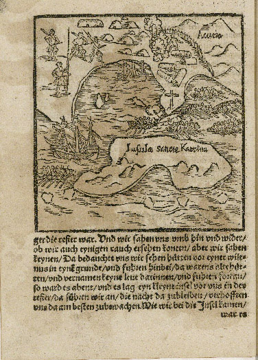
Staden’s map-like illustrations recount a sequence of events in a particular place similar to the vignettes found on the highly decorated Vallard Atlas or on the Rotz Atlas, drawn for Henry VIII but in the Dieppe style. But whereas the miniatures painted over the interior of Brazil in the Vallard or Rotz atlases are stylized, almost symbolic representations of moments of contact, trade, or war, Staden’s are highly personalized. For example, on the map-like illustration of the Island of Santa Catarina (fig. 2), two European ships and seven indigenous canoes share the waters. The mainland is presented as Guarani territory, with the village “Acutia” marked and named and the distinctive long houses known as ocas shown surrounded by a palisade. Staden’s illustrated map captures a specific moment in time: the encounter between the Spanish crew and the resident local Guarani on his visit. Four Europeans, including Staden, are shown ashore with their weapons, while a solitary cross marks the place where the men found a message.
Two illustrated maps of São Vicente (figs. 3 & 4) depict the place where Staden lived and worked as a gunner and where he was captured by the Tupinambá. Simultaneously the maps show São Vicente and relate Staden’s capture there. In fig. 3, the “map” forms the background to the illustration and lays out for the reader the landscape of the Portuguese settlement. Recall that this image is inverted. São Vicente is the island on which lies the town with the same name indicated by its initials (backwards): “.V.S” and the second settlement Santos, marked with an “.S.” A fortified sugar mill (ingenio i.e., engenho) is on the mainland, as is an exaggerated and mislabeled depiction of the frontier settlement of Bertioga. Staden lived and worked at the new stone fort shown opposite Bertioga on the island of Santo Amaro. In the foreground multiple events are taking place. Staden is captured while hunting and is taken away by the Tupinambá. Above fly the long-legged Scarlet Ibis (Eudocimus ruber) birds that were nesting at on an island near Santo Amaro. Prized by both Tupinikin and Tupinambá for their red feathers, Tupinambá paddled down from their villages to the north during the times when the birds nested. Thus, the outline of the coast represents continuous time, the birds represent repeating time (their migration and nesting at predictable times of the year), while Staden’s capture is immediate time.
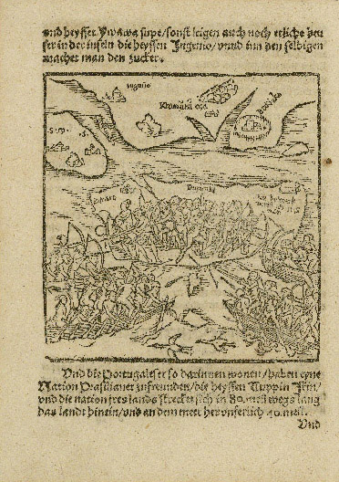
Figure 4 is not inverted and therefore São Vicente Island, with its two settlements of São Vicente and Santos, appears to the south of Santo Amaro Island. Bertioga is shown as a village surrounded by a palisade and the remoteness of the stone fort where Staden manned the guns is clearly evident. Its strategic value is made clear, as it defends the northern entrance to São Vicente Island and to the mainland where the sugar plantations were beginning to expand. In the foreground a battle is fought between the Tupinikin who, as allies of the Portuguese, are defending the island of Santo Amaro. Their foes are the Tupinambá who have entered Tupinikin territory on their annual hunt for the Scarlet Ibis birds and have captured Staden. Staden depicts himself standing up in a canoe and firing a gun. From the text we know that this is a French gun that was obtained by the Tupinambá from their French allies and that Staden was made to fire it by his captors.
A striking feature of the map-like illustrations is the clear outnumbering of the Tupi warriors to European or mixed-race mameluco soldiers. In figures 3 and 4, as in the other map-like illustrations in Staden’s book, the numerical superiority of the indigenous is consistently emphasized. This reinforces Staden’s depiction of the entirety of Brazil in his main map. For Staden, Brazil is a land owned and defended by indigenous groups.
Staden’s maps are deeply personal visual representations of his experience of Brazil. Staden blatantly positions himself in his illustrations and features himself in the legend of the fold-out map. This personalization underscores that it is Staden who is the eyewitness observer. The observer shows himself to convince the readers that they may believe what they see and read. Staden’s maps and illustrations are part and parcel of how he positions himself to tell his story.
When it came to writing his story, Staden was clearly influenced by the textually and visually rich sixteenth-century German print culture. That tradition encouraged him to “show” as well as “tell” what he had seen. Staden’s main map most likely derives from his exposure to nautical charts at sea and to maps drawn in the Dieppe style that he most probably saw in France after he returned. In this tradition of sea charts, Staden would have felt that his observations had value and that they could be added to the emerging conceptual understanding of the land and peoples he met in Brazil.
The naïve quality of Staden’s maps and illustrations, in that they were drawn by a lay person and not by an artist or cartographer, underscores that his audience was not intended to be the educated humanists and cosmographers, who would have expected him to be familiar with cosmography, but ordinary readers. Even the illiterate would be able to appreciate and even “read” his story by simply looking at the maps and illustrations. Staden’s illustrations and maps certainly engaged the reader more deeply with his story and underlined his authority as the eyewitness observer. This reinforced his underlying religious message.
Staden’s assigning of territorial possession to indigenous groups by the drawing of boundaries on his main map and his depiction of the power of indigenous warriors on the map-like illustrations are unique features of his mapping. This recognition of indigenous strength and autonomy emerges from Staden’s experience in Brazil. It is certainly not an accurate assessment of where tribal lands lay nor is it a detailed analysis of military might. Rather it is his impression, based on his own experience, and created without the need to satisfy reigning conventions of cartographic production or to declare loyalty to a reigning monarch with imperial or commercial designs on Brazil. As such it is a layman’s sketch and in this lies its value as a representation of Brazil in the middle of the sixteenth century.
References
Alegria, Maria Fernanda, Suzanne Daveau, João Carlos Garcia and Francesc Relaño (2007). Portuguese Cartography in the Renaissance. In David Woodward (ed.), The History of Cartography, Volume 3: Cartography in the European Renaissance. Chicago: University of Chicago Press. Part One, 975-1068.
Arens, William (1979). The Man-Eating Myth: Anthropology and Anthropophagy. New York: Oxford University Press.
Atlas Miller (1519). Paris: Bibliothèque Nacional de France.
Breydenbach, Bernhard von(1486).Peregrinatio in Terram Sanctam. Mainz.
Brito, Bernardo Gomes de (1998) [1735]. História trágico-marítima. Rio de Janeiro:
Lacerda editores/Contraponto.
Brunelle, Gayle K. (1991). The New World Merchants of Rouen, 1559-1630. Kirksville, MO: Sixteenth Century Journal Publishers.
Campbell, Tony (1978). The Woodcut Map Considered as a Physical Object: A New Look at Erhard Etzlaub’s “Rom Weg” Map of c. 1500. Imago Mundi, 30: 79-91.
Campbell, Tony (1987). Portolan Charts from the Late Thirteenth Century to 1500. In J. B. Harley and David Woodward (eds.), The History of Cartography. Volume 1: Cartography in Prehistoric, Ancient, Medieval Europe and the Mediterranean. Chicago: The University of Chicago Press, 371-463.
Campbell, Tony and Marcel Destombes (1987). The Earliest Printed Maps, 1472-1500. Berkeley: University of California Press.
Carta del Cantino (1502). Modena: Biblioteca Estense Universitaria.
Conley, Tom (2007). Early Modern Literature and Cartography: An Overview. In David Woodward (ed.), The History of Cartography, Volume 3: Cartography in the European Renaissance. Part One, 401-411.
Domingues, Francisco Contente (2007). Science and Technology in Portuguese Navigation: The Idea of Experience in the Sixteenth Century. In Francisco Bethencourt and Diogo Ramada Curto (eds.), Portuguese Oceanic Expansion, 1400-1800. Cambridge: Cambridge University Press, 460-479.
Dryander, Johann (1537). Anatomiae, hoc est, Corporis humani dissectionis pars prior . . . Marburg: Apud Lucharium Cervicoznum.
Dryander,Johann (1537). Annulorum Tirum diversi Generis Instrumentorum Astronomicorum . . . Marburg: Apud Eucharium Ceruicornum Agrippinatem.
Englisch, Brigitte (1996). Erhard Etzlaub’s Projection and Methods of Mapping. Imago Mundi, 48: 103-123.
Forsyth, Donald W. (1985). Three Cheers for Hans Staden: The Case for Brazilian Cannibalism. Ethnohistory, 32: 17-36.
Franco, Francisco de Assis Carvalho (1942). Introdução. In Hans Staden, Duas viagens ao Brasil, ed. Francisco de Assis Carvalho and translated from the German by Guiomar de Carvalho Franco. São Paulo: Publiçaões da Sociedade Hans Staden, 5-24.
Gómara, Francisco López de (1554). Historia de Mexico. Antwerp: Juan Bellero al Salmon.
Grenacher, F. (1970). The Woodcut Map. A Form-Cutter of Maps Wanders through Europe in the First Quarter of the Sixteenth Century, Imago Mundi, 24: 31-41.
Harisse, Henry (1893). Les Corte-Reals et leurs voyages au Noveau-Monde. Paris: Leroux, 215-216.
Harley, J.B. (2001) [1988]. Maps, Knowledge, and Power. In Paul Laxton (ed.), The New Nature of Maps: Essays in the History of Cartography. Baltimore: Johns Hopkins University Press, 52-81.
Johnson, Christine (2008). The German Discovery of the World: Renaissance Encounters with the Strange and Marvelous. Charlottesville: University of Virginia Press.
Johnson, Hildegard Binder (1963). Carta Marina: World Geography in Strassburg, 1525. Minneapolis: University of Minnesota Press.
Klarer, Mario (1999). Cannibalism and Carnivalesque: Incorporation as Utopia in the Early Image of America. New Literary History, 30: 389-410.
León, Pedro de Cieza de (1554). La chronica del Peru, Nuevamente escrita, por Pedro de Cieça de Leon, vezino de Sevilla. Antwerp: Martin Nucio.
Lestringant, Frank (1988). La ‘France antarctique’ et la cargographie prémonitoire d’André Thevet (1516-1592). Mappemonde, 88(4): 2-8.
Letts, Malcolm (1929). Descriptive List of the Woodcuts. In Hans Staden, The True History of his Captivity, 1557, ed. and translated from the German by Malcolm Letts. New York: Robert McBride & Co., xvii-xx.
Mancall, Peter C. (2006). Travel Narratives from the Age of Discovery: An Anthology. Oxford: Oxford University Press.
Marquez, Alfredo Pinheiro (1994). A cartografia dos descobrimentos portugueses. Lisboa: Edição ELO.
Martel, H.E. (2006). Hans Staden’s Captive Soul: Identity, Imperialism, and Rumors of Cannibalism in Sixteenth-Century Brazil. Journal of World History, 17: 52-69.
McCusker, John J. (2005). The Demise of Distance: The Business Press and the Origins of the Information Revolution in the Early Modern Atlantic World. American Historical Review, 110: 294-301.
Menninger, Annerose (1995). Die Macht der Augenzeugen. Neue Welt und Kannibalen-Mythos, 1492-1600. Stuttgart: F. Steiner.
Metcalf, Alida C. (2008). Hans Staden: The Consumate Go-between. In Franz Obermeier and Wolfgang Schiffner (eds.), Die Warhaftige Historia von 1557: Das erste Brasilienbuch, Wolfager Kongress zu 450 Jahren Hans-Staden-Rezeption. Kiel: Westensee-Verlag, 71-86
.
Meurer, Peter H. (2007). Cartography in the German Lands, 1450-1650. In David Woodward (ed.), The History of Cartography, Vol 3: Cartography in the European Renaissance. Chicago: University of Chicago Press. Part Two, 1172-1245.
Obermeier, Franz and Wolfgang Schiffner, eds. (2008). Die Warhaftige Historia von 1557: Das erste Brasilienbuch, Wolfager Kongress zu 450 Jahren Hans-Staden-Rezeption. Kiel: Westensee-Verlag.
Quinn, David (1986). Artists and Illustrators in the Early Mapping of America. The Mariner’s Mirror, 72: 224-273.
Roncière, Charles Germaine Marie Bourel de La (1910). Histoire de la marine française, 6 Volumes. Paris: Plon-Nourrit.
Sandman, Alison (2001). Cosmographers vs. Pilots: Navigation, Cosmography, and the State in Early Modern Spain. Ph.D.: University of Wisconsin.
Schnelbögl, Fritz (1966). Life and Work of the Nuremberg Cartographer Erhard Etzlaub. Imago Mundi, 20: 11-26.
Staden, Hans (1557). Warhaftige Historia und Beschreibung eyner Landtschafft der wilden, nacketen, grimmigen, Menschfresser Leuthen, in der Newenwelt America gelegen, [. . . ]. Marburg: Andres Kolben.
Staden, Hans (1929)[1557]. Hans Staden: The True History of his Captivity, 1557, ed. and translated from the German by Malcolm Letts, New York: Robert McBride & Co.
Staden, Hans (1942)[1557]. Duas viagens ao Brasil, ed Francisco de Assis Carvalho and translated from the Germany by Guiomar de Carvalho Franco. São Paulo: Publiçaões da Sociedade Hans Staden.
Staden, Hans (2007)[1557]. Warhaftige Historia zwei Reisen nach Brasilien (1548-1555) História de duas viagens ao Brasil, ed. Franz Obermeier and translated from the German by Joachim Tiemann and Guiomar Carvalho Franco. Kiel: Westensee-Verlag.
Staden, Hans (2008)[1557]. Hans Staden’s True History: An Account of Cannibal Captivity in Brazil, ed. Neil Whitehead and translated from the German by Michael Harbsmeier. Durham: Duke University Press.
Strauss, Walter L. (1984). The Illustrated Bartsch. Volume 13: (Commentary) German Masters of the Sixteenth Century: Erhard Schoen [and] Niklas Stoer. New York: Abaris Books.
TenHuisen, Dwight E. Raak (2005). Providence and Passion in Hans Staden’s Warhaftig Historia. In Mara R. Wade and Glenn Ehrstine (eds.), Foreign Encounters: Case Studies in German Literature before 1700. Amsterdam & New York: Editions Rodopi, 213-248.
Vallard Atlas (1547). San Marino, Ca: The Huntington Library, Digital Scriptorium Database.
Vespucci, Amerigo (1992). Letters from a New World: Amerigo Vespucci's Discovery of America, ed. Luciano Formisano and translated from the Italian by David Jacobson. New York: Marsilio.
Villas Bôas, Luciana (2005). Wild Stories of a Pious Travel Writer: The Unruly Example of Hans Staden’s Warhaftig Historia (Marburg 1557). In Mara R. Wade and Glenn Ehrstine (eds.), Foreign Encounters: Case Studies in German Literature before 1700. Amsterdam & New York: Editions Rodopi, 187-212.
Waldseemüller, Martin (1507). Universalis Cosmographia Secundum Ptholomaei Traditionem et Americi Vespucii Alioru[m]que Lustrationes . . . Washington, D.C.: Library of Congress.
Waldseemüller, Martin (1516). Carta Marina Navigatoria Portugallen Navigationes Atque Tocius Cogniti Orsis Terre Marisque. Washington, D.C.: Library of Congress.
Waldseemüller, Martin (2007). Translation of Large Text Block on Sheet 9 of 1516 Carta Marina by Martin Waldseemüller, translated from the Latin by John Hessler.
www.warpinghistory.blogspot.com.
Wallis, Helen (1983). The Rotz Atlas: A Royal Presentation. The Map Collector, 20: 39-42.
Wallis, Helen et al. (1981). The Boke of Idrography. In Jean Rotz, Boke of Idrography, ed. Helen Wallis. Oxford: The University Press, 35-72.
Whitehead Neil L. (2000). Hans Staden and the Cultural Politics of Cannibalism. Hispanic American Historical Review, 80: 721-751.
Whitehead, Neil (2008). Introduction. In Hans Staden’s True History: An Account of Cannibal Captivity in Brazil, ed. Neil Whitehead and translated from the German by Michael Harbsmeier. Durham: Duke University Press, xv-civ.
Wood, Denis (1992). The Power of Maps. New York: The Guildford Press.
Woodward, David (2007). Techniques of Map Engraving, Printing, and Coloring in the European Renaissance. In David Woodward (ed.), The History of Cartography, Volume 3: Cartography in the European Renaissance. Chicago: University of Chicago Press. Part One, 591-610.
Woodward, David, ed. (2007). The History of Cartography, Volume 3: Cartography in the European Renaissance. Chicago: University of Chicago Press.
Figure Two: Santa Catarina Island
Staden, Hans (1557). Warhaftige Historia und Beschreibung eyner Landtschafft der wilden, nacketen, grimmigen, Menschfresser Leuthen, in der Newenwelt America gelegen,
[. . . ]. Marburg: Andres Kolben.
Courtesy of the John Carter Brown Library at Brown University
Figure Two: Santa Catarina Island
Staden, Hans (1557). Warhaftige Historia und Beschreibung eyner Landtschafft der wilden, nacketen, grimmigen, Menschfresser Leuthen, in der Newenwelt America gelegen,
[. . . ]. Marburg: Andres Kolben.
Courtesy of the John Carter Brown Library at Brown University
Figure Three: São Vicente (Inverted)
Staden, Hans (1557). Warhaftige Historia und Beschreibung eyner Landtschafft der wilden, nacketen, grimmigen, Menschfresser Leuthen, in der Newenwelt America gelegen,
[. . . ]. Marburg: Andres Kolben.
Courtesy of the John Carter Brown Library at Brown University
Figure Four: São Vicente
Staden, Hans (1557). Warhaftige Historia und Beschreibung eyner Landtschafft der wilden, nacketen, grimmigen, Menschfresser Leuthen, in der Newenwelt America gelegen,
[. . . ]. Marburg: Andres Kolben.
Courtesy of the John Carter Brown Library at Brown University
Note
1Translated by Eve Duffy.
Copyright
2009, ISSN 1645-6432
e-JPH, Vol.7, number 1, Summer 2009
|
|
|