| |
|
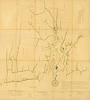
Narragansett Bay, 1741.
This map is another interesting find. Click on image to see detail of map and description of its discovery.
Original in the John Carter Brown Library. |
|
Where is Narragansett Bay?
The 1741 Boundary Dispute Between Rhode Island and Massachusetts
by Christopher L. Pastore
In the final hour of my final day as a JCB fellow, I opened an oversized black leather-bound codex decorated with gold filigree. Containing more than 400 pages of neat, looping longhand, this nineteenth-century transcription of an eighteenth-century colonial court record appeared at first glance to be yet another example of England’s assiduous but dry imperial record keeping. But the impressive binding and the text’s careful rendering by a London book dealer suggested otherwise. After a closer examination, I decided to extend my stay.
Titled "A Copy of the Record of the Proceedings of the Commissioners for settling adjusting and determining the Boundary of the colony of Rhode Island and Providence Plantations Eastward toward the Province of the Massachusetts Bay," this 1741 court case considered Rhode Island’s claims to the eastern shores of Narragansett Bay. Citing its 1663 royal charter, Rhode Island claimed the lands “extending … three English miles to the east and north-east of the most eastern and north-eastern parts of … Narragansett Bay.” Rejecting its neighbor’s claims, Massachusetts Bay, which had acquired the lands when it absorbed Plymouth Colony in 1691, argued that the contested space known as the “Attleboro Gore” did not actually touch the shores of Narragansett Bay. The question of who held jurisdiction, therefore, depended on the Bay’s location.
As an environmental historian examining the history of estuaries (and Narragansett Bay in particular) and the ways their watery nature blurred legalities and obfuscated jurisdiction, I was struck by the political, legal, and conceptual implications of this case’s central question: where is Narragansett Bay? To answer it required both colonies to define this brackish borderland in terms of imperial mandates, historical mapping, colonial wars, and Native American and European vernacular knowledge. And to do that both Rhode Island and Massachusetts called scores of deponents from all walks of life, including, among others, gentlemen, sailors, coastal farmers, and Wampanoag Indians, who explained to the court how they understood the boundaries of land and sea, saltwater and freshwater, and in many cases how those ideas had changed over time.
Their answers were varied. For some, Narragansett Bay was a small body of water that lay between the Narragansett Country to the west and Newport on Aquidneck Island to the east. For others, the Bay stretched between Fisher’s Island on Long Island Sound and Gay Head at Martha’s Vineyard. And still others imagined Narragansett Bay bounded by any number of points in between. Their justifications for these borders, as revealed in the court record, illuminate not only their political loyalties but also the ways people worked and lived in the coastal zone. They reveal the ways first- and second-generation English immigrants understood property ownership. And they even reveal the ways eighteenth-century men of letters thought about some of the most important seventeenth-century published histories of the region—those that are frequently cited in historical scholarship today.
Ultimately, the boundary commissioners ruled in favor of Rhode Island, a decision that has been well documented in numerous histories of both colonies. But a careful examination of the court case in its entirety underscores the extent to which Early Modern coastal space, at least to colonial English sensibilities, was at once defined by the convergence of metropolitan directive and littoral culture on the periphery and muddled by the mixing, moving, complex ecology found at the nexus of land and sea. |