


w. George LoVell: Helen Watson Buckner Memorial fellow, 2003-2004; Maury A. Bromsen Fellow, 2010-2011 A Tale of Two Maps |
 |
|||
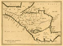
The map that interested me most was one with which I was already familiar—or so I thought until a Helen Watson Buckner Memorial Fellowship took me to the John Carter Brown Library in 2004. My appreciation of Antonio de Herrera’s “Descripción del Avdiencia de Gvatimala” (see Map 1) was shared by Christopher H. Lutz, and we took great delight in the map adorning as endpapers one of our books, Demography and Empire (Lovell and Lutz 1995). Herrera’s minimalist cartography of the Central American isthmus served as the perfect backdrop for our project, which was to highlight aspects of the population history of a region woefully understudied in the Latin American scheme of things. |
Map 1 |
|||
Herrera’s map, I knew, was one of fourteen he had prepared, as the Spanish Crown’s cosmographer and chronicler, for the Descripción de las Islas y Tierra Firme del Mar Océano (1601), a distillation of his four-volume work in progress, Historia general de los hechos de los castellanos (1601-15). Though afforded opportunity beforehand to peruse the “Descripción del Avdiencia de Gvatimala” on its own, never had I had occasion to consult it as part of the larger whole from which it had been excised. It was with a keen sense of anticipation, therefore, that I called up Herrera’s Historia general (1601-15) for consultation in the JCB Reading Room. I was relishing seeing, for the very first time, Herrera’s map alongside his text when curator Susan Danforth sauntered by. |
||||
“Interested in Herrera and his maps, are we? Would you like to see the manuscript that he based them on?” |
||||
| She smiled at my incredulity. “Well, yes, I’d love to,” I muttered, totally unprepared for what Susan subsequently handed me. “There you go. Remember, we’re all copy cats in one form or another.” | ||||
I was aware that information reaching the Council of the Indies in Spain was reconfigured and recycled to suit different imperial objectives, but not until Susan showed me the manuscript of Juan López de Velasco’s Demarcación y división de las Yndias (Madrid [?] 1575 [?]) did I realize the full extent of the practice. Just as Herrera constructed much of his narrative on what Bartolomé de las Casas had to say, so too did he ground his cartography on maps conjured up by López de Velasco. |
||||
This is most apparent if we examine Herrera’s map alongside one made a quarter-century earlier by López de Velasco, to which it bears striking resemblance (Map 2). The latter’s map is an attractive watercolor, its washed-out hues allowing the traces and inscriptions of an ink pen to stand out and be admired. Herrera had at his disposal other cartographic material besides that produced by López de Velasco, but none he consulted must have appealed to him nearly as much, given the degree to which he replicated from that key source. Herrera adds and embellishes, recording more settlements, inserting range after range of mountains, and changing the name “Veragua” to Panama. But he also eliminates internal boundaries, obscuring the territorial limits over which Spanish-founded cities held administrative sway, their jurisdictions the embryo of future Central American nations. His overall creation, albeit sharp and elegant, is a pared down reprise, an exercise in selective recycling. |
Map 2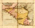 |
|||
Our subsequent analysis of this cartographic connection (Lovell and Lutz 2011) is but one of many outcomes arising from delving into the John Carter Brown Library, the treasures of which are a joy to work with. |
||||
References Cited: Lovell, W. George and Christopher H. Lutz. 2011. “Between Two Seas: Antonio de |
||||