CHAMPLAIN'S AMERICA: NEW ENGLAND AND NEW FRANCE The year, 2008, marks the four hundredth anniversary of the founding of Quebec by Samuel de Champlain, an American explorer who doesn’t receive nearly enough credit south of the Canadian border. He would have been confused, in fact, by the distinction between what is now Canada and what is now New England. He had mapped its coastline extensively long before the Pilgrims came to Plymouth, giving names such as “Beau Port” and Malebarre” to places now called by their English names of “Gloucester” and “Cape Cod.” For Champlain, America was a lifelong obsession, and his twenty-nine journeys across the Atlantic Ocean brought him from the Caribbean to the northern reaches of North America. More than just an explorer, he was a brilliant actor, inspired map-maker, and accomplished writer. His genius for writing and promoting the new world he found led to the establishment of a resilient Francophone community in Quebec, still vibrant after four hundred years of existence. France and England’s battle over dominion of the area delineated by Champlain extended for almost a century and a half in the lands known variously as New France and New England. Caught up in the imperial conflicts of their home countries, the colonists were deeply unsettled by the presence of the other population to their north or south. This exhibition documents the complicated relationship in the area from the moment of discovery to the British conquest of Quebec City. Facing a harsh climate and limitless adversity in a forbidding and unknown new world, the two societies--then as now--had a great deal to learn from each other. The two following maps represent divergent views (English and French) of North America. |
||
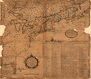 |
New England Warns of the French Threat Cyprian Southack, [A new chart of the English Empire in North America], Boston 1717. In this first copperplate map published in the British colonies, the New England view that the French were poised to push the New Englander's into sea makes it essentially a "war map." Southack take pains to point out (with crosses) the location of the French forts that surrounded the British colonies. |
|
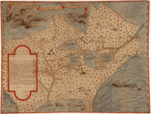 |
Knowledge and Possession In 1673 the French fur trader Louis Jolliet and Father Jacques Marquette, a Jesuit missionary, explored the Mississippi River, but records they kept of their trip were lost in a canoe accident. Upon his return to Quebec, Jolliet drew a map from memory, and the manuscript shown here—one of the earliest representations of the course of the Mississippi—is one of several copies that were made at the time. Away from the areas the French party actually traversed, the geography is fairly poor, but the map accurately shows the location of various Indian nations, information of vital interest to French traders and missionaries. The cartouche at the left is a copy of a letter to the Governor of New France, Count Frontenac, in which Jolliet alludes to the fertility of the country and also to a (non-existent) water passage that would connect the Atlantic and Pacific coasts. With this kind of information about the interior readily available to the French, New Englanders' concerns were certainly realistic. |
|
Exhibition seen in Reading Room from september 2008 through Exhibition prepared by Susan Danforth, Curator of Maps and Prints. |
![]()
![]()

![]()


Detail from Samuel de Champlain, Les voyages du sieur de Champlain Xaintongeois, Paris, 1613