MAPs to describe land use and settlement |
||||
 |
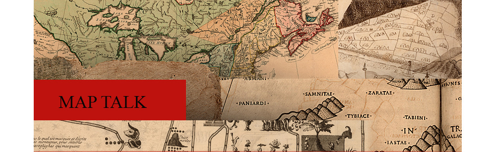
17. [Estate plan of 300 acres of land near Holetown, Barbados]. Surveyed by John Hapcott, October 10, 1646. This plan shows the layout of a Barbados estate at the time when sugar production was being established and the island was beginning its phenomenal rise as the most valuable of England’s American colonies. The original heavy forest cover of the island presented a formidable problem for early would-be planters, who often started their crops between the stumps of trees that had been cut and partially burned. As sugar cane became profitable in the 1640s the destruction of the forests proceeded more rapidly, and by 1665 firewood had to be imported from as far away as New England. “Fallen land” at the upper right signifies areas that have been cleared for agriculture. Potatoes were important in the early colonial life of the island, used for making bread and for an alcoholic drink called mobbie. Note the “potato peece” at the upper right. The building drawn at the right is a church. It’s still standing and looks very much like this 17th c. portrait. The plan was mounted on hinged wooden boards for protection and portability. |
|||
 |
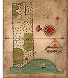
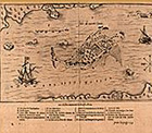
18. “Mountserrat Island 1673.” In: The Blathwayt Atlas. [London, ca. 1683]. Manuscript. Identifying landfalls and harbor entrances with “profiles” of the land as it would appear from offshore was a longstanding maritime tradition that continues almost unchanged to this day. This unusual map of the Caribbean island of Montserrat—a series of coastal profiles strung together—was probably executed by a mariner. The land is drawn in minute detail and there is an extensive key to buildings and places. No separate map of the island was published in the seventeenth or eighteenth centuries. The manuscript map shown here is a valuable window into the past that has been used by modern scholars to analyze seventeenth-century land-use patterns. It has been suggested that the figure at the lower left may be a self-portrait of the cartographer. For another map of Montserrat, see no. 16. |
|||
| 19.Thomas Holme. A portraiture of the city of Philadelphia. London, [1682]. | ||||
 |
20. Directions of reference in the city draught of Philadelphia. [ca. 1682]. Manuscript. In March, 1681, William Penn received a charter from Charles II naming him governor and proprietor of Pennsylvania. Four months later, Penn had produced a general colonization scheme that included plans for the establishment of a great city to be called Philadelphia. By the summer of 1682, a site had been selected and the newly appointed surveyor, Thomas Holme, was preparing to lay out the town. The grid pattern, which was to become synonymous with the idea of North American urban living, had a long history of use by Spanish, French, and English colonial planners. However, the incorporation of open green spaces and sites for public buildings and residential squares was probably based on Richard Newcourt’s plan for reconstructing London after the Great Fire of 1666. |
|||
 |
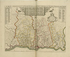
21. “Habitasion de l’isle Ste. Croix.” In: Samuel de Champlain. Les voyages. Paris, 1613. In 1604 Pierre du Gua, Sieur de Monts, received exclusive Canadian fur trading rights from the French king, Henry IV. He organized an expedition to reconnoiter the area and to establish trading centers, the first of which was Sainte Croix (now Dochet Island) on the Maine coast. Samuel de Champlain, geographer for the voyage, laid out the settlement with living quarters, gardens, a mill, and an oven. During the winter, however, the exposed site proved so inhospitable that it was abandoned the following spring, and it is unlikely that the actual settlement bore much resemblance to Champlain’s neat perspective plan. |
|||
| Exhibition prepared by susan danforth. on view in the reading room from January 27 to april 23, 2010 |