MAPs to record possessions and boundaries |
||||
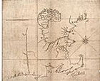 |
22. [New England, showing Massachusetts boundaries, 1678]. Manuscript. In the original charter the Charles River in the south and the Merrimack River in the north formed the boundaries of the Massachusetts Bay Company because it was assumed that the course of both rivers was generally due west-to-east. After further exploration, the Massachusetts settlers realized that the source of the Merrimack River was much farther to the north, and that the river flowed south for fifty miles before turning eastward toward the sea. Since their charter entitled them to all lands as far as three miles north of any part of the river’s course it seemed that the colony could legally increase its territory by a considerable amount. This map was drawn to present the Massachusetts Bay Colony’s position to the Lords of Trade and Plantations. They did not win their case. |
|||
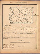 |
23. “ No. 6 … The draught of a tract of land called “Farmers Delight.” In: Draughts of Virginia lands the property of Doctor Benjamin Say. Plan of lots in the City of Philadelphia the property of Dr. Benjamin Say. [ca. 1790-1826]. Manuscript. The Say family recorded their extensive land holdings in Kentucky, Virginia, western Pennsylvania, and the city of Philadelphia in this handbook. The dated entries coincide with the surge of land speculation at the close of the Revolutionary War that went hand-in-hand with the United States’ western expansion to the Mississippi River. |
|||
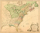 |
24. Thomas Kitchin, A new and accurate map of the British dominions in America. [London, ca. 1764]. Rivalry between France and England escalated throughout the eighteenth century, but not all skirmishes between the two powers took place on the battlefield. Cartography provided a public forum for questions of possession and ownership that was less bloody, perhaps, but no less intense than military action. Here French and British cartographers fight their war with color, which highlights their difference of opinion over who controls what territory in North America. |
|||
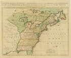 |
25. S. G., Sieur de Longchamps, Carte des possessions Françoises et Angloises. Paris, 1756. | |||
| Exhibition prepared by susan danforth. on view in the reading room from January 27 to april 23, 2010 |