 |
Mapping the Underground |
|
Maps and plans depicting the exterior and interior spaces of mines were rare in Latin America until the eighteenth century, and overwhelmingly these maps exist in manuscript form only. Nevertheless, many published maps of the Americas, the vast majority of which were published in northern Europe, clearly reveal their makers' preoccupation with the metallic wealth that lay or was imagined to lie beneath the earth's surface. |
||
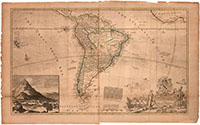 |
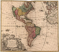
12. Herman Moll, "Map of South America" (London, 1709-1720). The details of this map unequivocally reflect northern European interest in the mineral wealth of Spanish and Portuguese America. Careful study reveals numerous references to gold mining sites, especially in the Amazon regions. The theme of precious metals is equally apparent in the map's decorative elements. An illustration of Potosí's silver mountain dominates the lower left hand corner, while ingots and coins are depicted below the legend. |
|
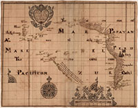 |
13. William Hack, "An accurate description of all the harbours rivers ports islands sands rocks and dangers between the mouth of California and the straits of Lemaire in the south sea of America" (London, after 1698) |
|
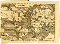 |
14. "Ebbe und die Flüth auff einer Flachen Landt-Karten fürgestellt," Eberhard Werner Happel, Mundus mirabilis tripartitus, vol. 1, Ulm, 1687. Remarkable emphasis is placed on Potosí in these late seventeenth century English and German maps. William Hack drew his map on the basis of Spanish charts captured in 1681 by an English privateer. Happell's map depicts South America as the world's most volcanically active region. Some early modern accounts of American nature proposed a causal connection between volcanic activity and abundant mineral wealth. This connection is also readily apparent in other maps included in this display. |
 |
 |
15. August Gottlob Böhme, "Americae Mappa generalis" (Nuremberg, 1746). The decorative elements around the legend of this mid-eighteenth century map repeat the visual references to mineral wealth and volcanic activity in Herman Moll's map of South America (included in this display). |
|
| the Exhibition may be seen in the reading room from April 2015 through august 2015. |