Places
Haiti's striking geography determined its destiny.
From the moment Columbus journeyed to the New World, the place that would become Haiti impinged upon Europe’s consciousness, first as a single line drawn by Columbus as the first step toward a map, and then as an actual settlement. Indeed, La Navidad, founded on Christmas day 1492, was the first European settlement in the Americas, near the site of today’s Cap Haïtien. That settlement lasted less than a year, but eventually a French colony emerged on the western half of the island Columbus had named Hispaniola (or “little Spain”). From modest beginnings concentrated on the island of Tortuga (Tortue) and Haiti’s northern coast, French colonists eventually assumed control of land resembling the current contours of Haiti, which they named Saint Domingue, the French version of Santo Domingo, the city Bartolomeu Columbus had founded on the southern coast of the island (now the capital of the Dominican Republic)
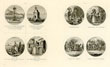
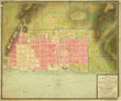
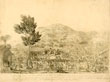
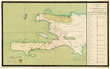
The geography of Saint Domingue and Haiti – the fertile northern plains, the harbors that allowed cities like Cap-Français (now Cap-Haïtien) and Port-au-Prince to develop, and the mountains of the interior – shaped the development of the country. Indeed, “Haiti” means “mountainous land” in the language of its original indigenous inhabitants. Economic development was always connected to the land and its capacity for different forms of agriculture, and French scientists in the colonial period wrote prolifically about the island’s natural setting. A sample of their writings may be consulted here. In addition, a variety of city views and maps of Haitian places are available. The French genius for cartography was amply on display as the colony of Saint Domingue grew and prospered.