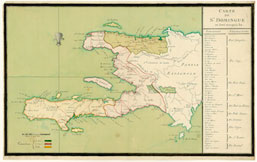


Carte de St. Domingue
Author:
Place of Publication: s.l.
Publisher:
Publication Date: [1770]
Physical Description: separate map
Description:
This hand-colored manuscript map is one of the John Carter Brown Library’s most unique holdings. The map focuses almost exclusively on French Saint-Domingue, without a full view of Spanish Santo Domingo. The north, west, and south regions created by the French colonists are delineated, and the right-hand side features a detailed list of Saint-Domingue’s parishes and jurisdictions. The map is primarily political and administrative. Other details include the locations of rivers, lakes, and bays.
Notes: C-8205