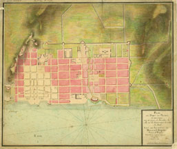


Plan du Port-au-Prince et environs avec un projet de Fortifier la ville en la diminuant du côté du Sud.
Author: Péchon, Jean Bounet
Place of Publication: [Port-au-Prince?]
Publisher:
Publication Date: 1794
Physical Description: separate map
Description:
The John Carter Brown Library holds this special map of one of the two main cities in Saint-Domingue. This color manuscript map (57 x 67 cm.) depicts the plan of Port-au-Prince in 1794 showing a proposed revision of the fortifications of that town added in an overlay. This map has a manuscript inscription in the upper left hand corner reading “No 1 portfolio 3 The Rt Honble H. Dundas”. Henry Dundas, first viscount Melville, served as the British Secretary of War from 1794 to 1801. This map must have been part of his important cartographic resources during the period when Great Britain occupied Saint-Domingue beginning in 1793. On June 4, 1794, British forces under the command of Brigadier General Richard Whyte occupied the town and began making plans for fortifying the defenses. This plan must have been drawn by a member of the French military engineers. The British remained in Port-au-Prince until 1798 when the island was completely evacuated.
Notes: map 32187-1