A Reimagined Middle East
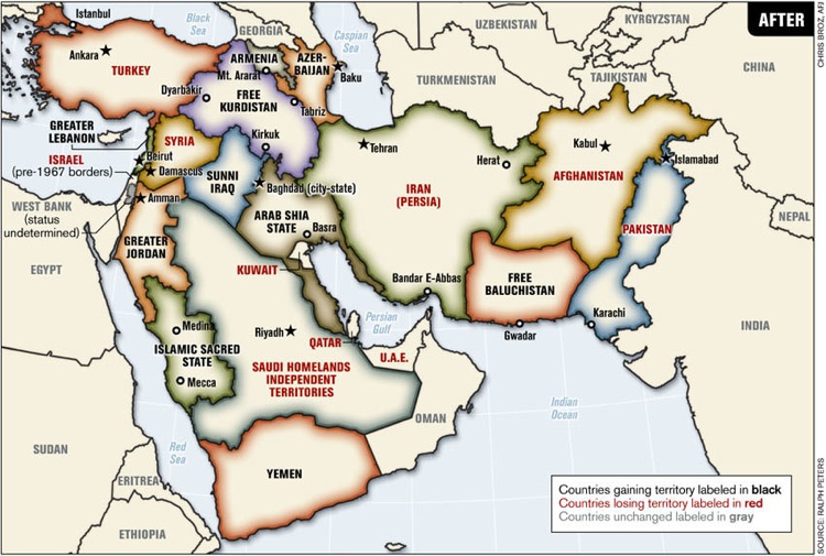
Image Taken From the June 2006 Armed Forces Journal [link]
At a time when the United States is so deeply involved with the Middle East I thought it fitting to bring up this reimagined map of the Middle East from the Armed Forces Journal. I would also want to preface this map by commenting that as a proposal it is utterly ridiculous, but it remains a strong critique of the border based conflict that exists in the Middle East. This is a mental exercise in realizing the ‘organic borders’ of the Middle East where no minority, Kurds, Baluch, Arab Shia, Middle Eastern Christians, Bahais, or Naqshbandis, not to mention the myriad other groups can be truly and fully satisfied.
Being home to a multitude of ethnic groups and world religions the Middle East is a hotbed of potential conflict made manifest by arbitrary borders. Europeans (who have had their own share of disastrous map drawing) for the most part broke apart the Ottoman Empire without consulting the history, languages, ethnicities, religious issues, aspirations, or needs of the people that live in the Middle East.
One can compare the maps of 1916 drawn up by Sykes-Picot and the map touted by T.E. Lawrence [link] to see the various ways people have redrawn the borders of the Middle East. For diplomatic reasons the Lawrence map was considered but ultimately rejected despite Lawrence’s real experience in the Middle East with its people and culture.
Going back to the Armed Forces Journal redrawing of the Middle East, there is a clear call for the redrawing of borders based on blood and faith. However, look at the problem areas of Israel and Kashmir, left unresolved by the map. There is a clear American bias here shown by the enlarged and pro-USA state of Kurdistan (sorry Omur). The powers of Iran, Saudi Arabia, and Pakistan, get eroded. Hilariously, the acronym for the new Saudi state is S.H.I.T. Saudi Homelands Independent Territories, a poignant commentary of the current view of the ruling Saudis.
Maps are curious in this way. They are all too often man-made monstrosities that barely reflect any reason whatsoever and are colored by the minds that put the drawing ink to paper. Peace in the Middle East? Maybe. It will take time and the readjustment of the multitude of institutions that bias and govern the whole region.
Here’s a map of the last more or less stable Middle East. [link]
Of particular interest for those looking for a website entirely dedicated to maps (strange ones) is Strange Maps. [link]
