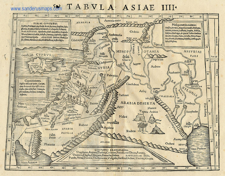
The original title of this map is “Tabula Asiae IIII” although the map is currently known as “Antique Map of the Middle East”. It was created by Sebastian Muenster in 1540 as a part of his “Geographia Universalis vetus et nova … Claudii Ptolemai Alexandrini…” This book, based on the writings of Ptolemy, showed the world as Europeans knew it during this time period.
This map shows what was known, at the time, of the Near/Middle East. I originally chose it because I found the addition of the tents and palm trees enchanting. Later, I discovered that this was typical of the time period. Mapmakers often filled in blank spaces on their maps with drawings. I also found a poem on the subject:
“So geographers, in Afric maps
With savage pictures fill their gaps
And o’er uninhabitable downs
Place elephants for want of towns”
Jonathan Swift, On Poetry: A Rapsody, 1733
Muenster saw cities as proof of civility, learning and antiquity. Many are shown on this map and scholars note that Muenster also usually noted monasteries on his maps. There is an unusual tower or fortress on the right side of the map and I was unable to determine what it represents. Trees have been added to the mountains near Damascus and probably indicate the famed “cedars of Lebanon”. However, Muenster considered everything except God to be unchanging and pointed out that many once famous and memorable places were now deserted and neglected. In his Cosmographia, Muenster writes:
“Where are Babylon, Troy, Thebes, Carthage, Athens and all the other cities of which the historians speak so magnificently? … The city of Babylon was once noted for its size and height; now even its location is unknown.”
Thus, I found it puzzling that Babylon is given a location on this particular map.
Muenster, a professor of Hebrew at the University of Basel, also published a later book, Cosmographia, in 1544 which was one of the earliest descriptions of the world in German. Muenster was the first mapmaker to create separate maps of each of the continents and to list the sources that he used. This was an immensely popular book, going through 24 editions in its first 100 years of publication. The popularity of this book is attributed to the excellent woodcuts like this map and it is considered to have been instrumental in reviving interest in geography in 16th century Europe.
This map is from the sanderus.com website. Sanderus Antiquariaat is a mapseller located in Ghent, Belgium.
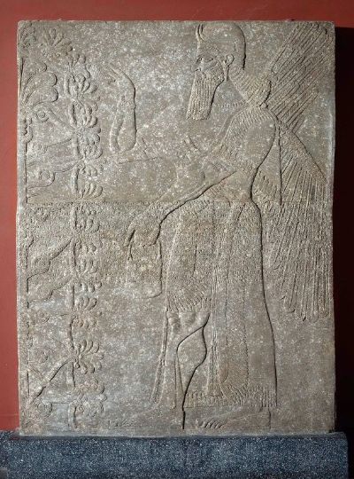
"Relief of a Winged Genius", Reign of Ashurnasirpal II, 883-859 B.C.
This artifact is from the Museum of Fine Art in Boston. Accession number: 35.731. Findspot: Nimrud. Height x Width: 221.7 x 176.3 cm. On view: Ancient Near East Gallery. Description: Winged genius (human-apkallu, antediluvian sage) facing left, holding a bucket and cone, fertilizing the "sacred tree." "Standard Inscription" of Ashurnasirpall II across center of slab. Provenance: From Nimrud (ancient Kalhu, biblical Calah), Northwest Palace. By 1850s: excavated by Sir Henry Layard, obtained from Layard or Sir Henry Rawlinson, by Reverend W.F. Williams on behalf of Reverend Sylvester D. Storrs; 1860, presented by Storrs to the Andover-Newton Theological School; 1935: purchased by the MFA from the Andover-Newton Theological School for $10,000.
Source of image: mfa.org/collections
