Taken from http://www.iscra.nl/a3015.htm
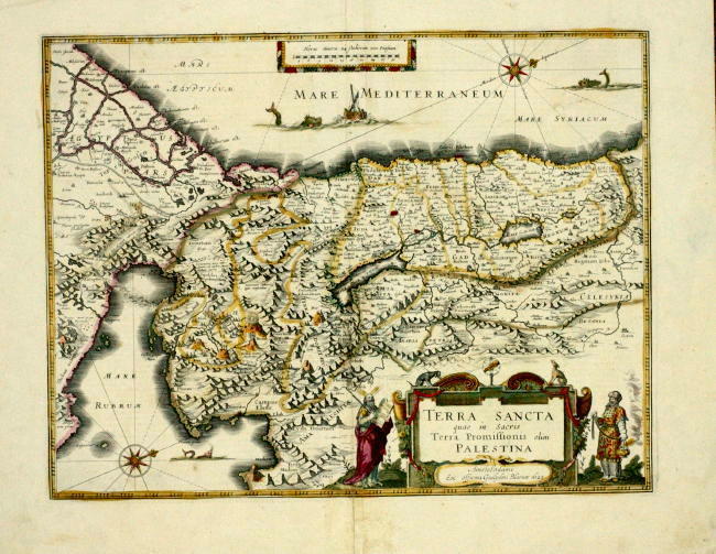
This map is called Terra Sancta qua in Sacris Terra Promissionis olim Palestina. An established Dutch cartographer named Willem Blaeu drew up this map in 1629. The map seems fairly accurate; or, at least as accurate as a map of Palestine could be in the early 17th century. However, there is one very obvious detail in this map: Everything has been flipped 90 degrees clockwise, so that west is now north. Apparently, the intention was to portray the Holy Land as Moses, standing on Mount Pisgah, would have seen it at the end of his life, with the crystaline waters of the Mediterranean in his view.
I've always found the orientation of maps very interesting. Why is it that Europe is on the Northern Hemisphere, while Africa + South America are on the Southern Hemisphere? Well, the obvious answer is that Europeans were the first ones to map the whole world, so they chose Europe to be the northern, dominant continent. I feel like that northern bias is evident in this map here, too. If you follow the yellow line, which marks Moses's wanderings through the desert, you'll see that, despite stumbling, Moses is eventually facing the Mediterranean, and also towards Europe. So symbolically, Moses is facing "north" in this map, signifying perhaps the upwards progress of man, worshipping but one god, as portrayed in Exodus. However, in reality, Moses is facing west, which in itself could represent the recurring theme of "passing the torch of civilization" from the East to the West.
