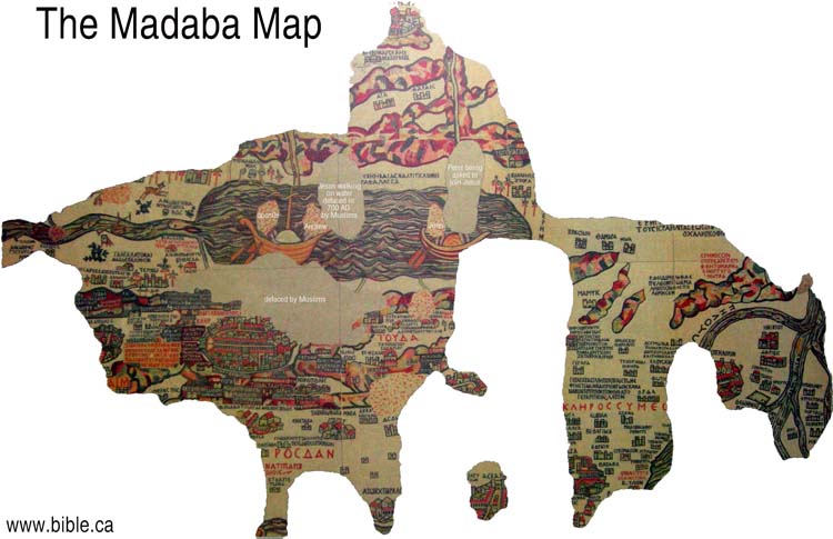
The map I chose is unique not only in its design and origins but also in the very materials used to create it. The Madaba Map is not a typical transportable tool of orientation but is rather an ancient mosaic created sometime in the sixth century AD that resides permanently on the floor of a historic Byzantine church in Madaba, Jordan. The area it covers ranges from Egypt to Lebanon and is portrayed from a definite biblical point of view. The landmarks and pictures detailed on the map are primarily present due to their biblical importance. In fact Jerusalem is one of the main focal points of the map and contains the most detail in its depiction. One of the map’s main purposes was to guide Christian pilgrims on their quests to places of holy significance. Accordingly, not only are physical locations such as Bethlehem depicted but present too are topographic representations that express characteristics of significance to a traveler. Ferries are present on the Jordan River to indicate spots for fording, and lions, gazelles, and bushes are just a few other examples of symbols present to indicate characteristics of climate, fauna, and obstacles to travel.
The Madaba map as it is today is far from an exact geographical representation of its domains. Strict observance to scale and exact positions is absolutely absent and multiple areas of the original map are no longer in place. The physical history of this map is symbolic of the enormous tensions that have existed between the peoples whose homelands are represented in this curious cartographic illustration. Around 700 AD Muslims reportedly vandalized and removed multiple portions of the map, pointing to its symbolic significance to both those whose viewpoints it showcased and those whose it did not. It was created for the specific purpose of Christian devotion and edification as well as for a specifically Christian audience. For this reason it is certainly not a fair or unbiased representation of the area which it portrays as it steeps the area in images of significance to the Christian population of the time but omits any allusions to other cultures’ achievements. This bias does not necessarily detract from the enormous importance and significance of this early map but it certainly must be kept in mind when analyzing it as a historic document. This image comes from the website < http://www.bible.ca/archeology/bible-archeology-exodus-madaba-map.htm>. The website shows itself to hold a Christian bias. Though this does not take away from the significance of the map it is important to keep this in mind particularly when noting the captions and explanations added to the map by the website’s creators.
Posted at Sep 22/2009 10:11AM:
Posted at Sep 22/2009 10:13AM:
Grace: http://www.bible.ca/archeology/bible-archeology-exodus-madaba-map.htm
 Puabipictures.doc