Curious Maps of the Middle East: "The New Middle East"
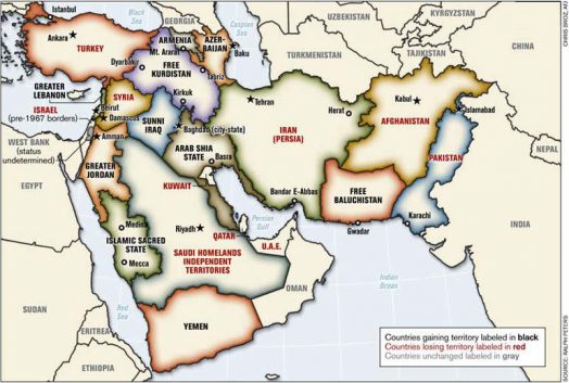
Photo Credit: http://morris108.wordpress.com/2008/09/16/map-the-new-middle-east-not-official-but-assumed-to-be-in-circulation-in-military-circles/
This map was published in the Armed Forces Journal in June 2006, offering an alternative political geography for the Middle East. I picked this map because it is relevant to the historically important issues of identity and landscape in the region. The borders of the Middle East as they exist today were largely products of European foreign service officers drawing lines on a map to maintain a balance of power after the World Wars. This map rearranges the borders to better accommodate the various ethnic and religious groups of the region, presumably for the cause of stability by putting “like with like.”
Historically speaking, the people of the Middle East have never lived in ethnically isolated groups: the whole region has spent most of history as part of a centralized imperial system, be it Assyrian, Hellenistic, Roman, Persian, Arab, or Ottoman. This map represents an attempt to reconcile a diverse area with modern notions of the homogenous nation-state, a relatively new idea in the history of the Middle East. Ignoring the many stable periods of a non-fragmented Middle East, this map assumes that tensions in the region will be solved by drawing borders based on ethnic groups, instead of something more practical, e.g. natural resources (“Sunni Iraq” is a landlocked patch of desert with little oil reserves). This also presupposes that these ethnic groups are already neatly spread out, thus ignoring individuals and their ties to the landscape. For example, there would certainly be Sunnis already living in the “Arab Shia State” whose families may have been there as long as the Shiites’. Home is home, regardless of minority status. Similar population shifts were ordered after the independence of Greece and the partition of India, both of which were painful for all involved. This map represents the belief that drawing lines on a map can solve problems between groups of people and the perils of ignorance of history.
