Assignment 1: Maps are territories: an assignment on the cartography of the Near East.
Due Sept 18, Monday.
Find or create a map of the Near East or a region within the Near East of your choice, write a paragraph about it and post it here (below) on the wiki site. The goal is to challange the idea of a map as a representation of a geographical reality. Your map should be an interesting one, either scanned from a published book or article, or found on the web, or created by you from scratch. You can alter the scanned map if you wish or simply leave it as it is. It is important that you provide image credits with your scanned map if you use one, indicating its source. See for example Image Credit of the image on our main course page.
Reading:
Excerpts from David Turnbull, Maps are territories, science is an atlas. The University of Chicago Press. (handout).
Post your maps here:
Maps and cultural geography: they give away the mentalities, ideologies of their (map)makers.
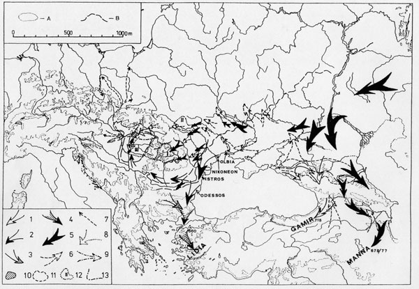
The supposed Cimmerian and Scythian migrations during the 8th and 7th centuries B.C.
Image Credit-004

More migrations in the Black Sea area in antiquity. Imag(in)ing nomadism Image Credit-005
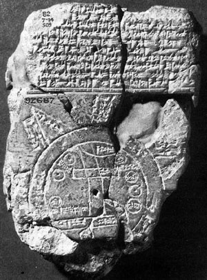
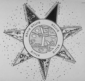
Omur Harmansah: The so-called Babylonian map of the world. Clay tablet in British Museum Inv. 92687. Published by F.E. Peiser in Zeitschrift für Assyriologie und Vorderasiatische Archäologie 4 (1889) 361-370. It is dated to the first half of the First Millennium BC. The geographical knowledge of the Mesopotamian core territory is presented in a non-scalar graphic manner, with fair amount of accuracy, spotting certain regions and cities (some of which were labeled) around prominent mountains and rivers. The visual representation of this geography uses a cursory but identifiable veracity, while the unknown edges of the inhabited world (dadmū) are geometricised in the pictorial representation and mytho-poeticized in its verbal ekphrasis. The report of the fauna of the inhabited world in the text that accompanied the drawing, is specifically concerned with the content of the mythical marginal landscapes, the distant lands, listing those animals created by the god Marduk “on top of the sea”. The comprehensive list of the fauna comprises: the anzû-bird, the scorpion-man (girtablullû), sea-serpent (mušhuššu), gazelle (armu, ‹abītu), zebu, water-buffalo (apsasû), panther (nimru), bull-man (kusarikku), lion (nēšu), wolf (barbaru), red-deer (lulīmu), hyena (būsu), male/female monkey (pagû/pagītu), ibex (turāhu), ostrich (lurmu), cat (šurānu), chameleon (hurbabillu). The text presents a liminal knowledge of the fabulous landscapes in a mytho-poetic narrative of mapmaking. The major concern is not the obvious well-known landscape of Mesopotamia, but its fictitious periphery that needed to be presented.
Posted at Sep 17/2006 10:06AM:
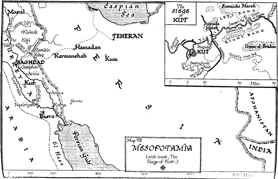
Emma Maines: This map is both a source of geographical and historical information. While it is primarily a depiction of Mesopotamia, the detailed inset lends another dimension to the map. The inset is an illustration of the Siege of Kut-al-Amara, a battle that took place on the banks of the River Tigris between the British and the Turkish. The conflict lasted from early December 1915 to late April 1916. It was a great loss for the British. I found this map particularly interesting because of its visual representation of foreign investment and interest in Mesopotamia.
Posted at Sep 17/2006 07:30PM:
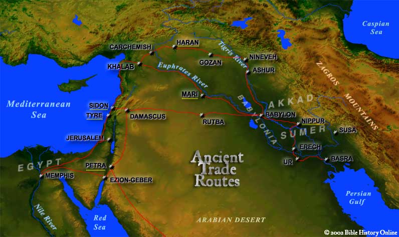
kat read: This map is serves as a depiction of ancient trade routes. The red lines represent ancient trade routes, while the underlined cities represent important hubs of trade in the ancient Near East.
This map combines modern cartography with ancient trade routes to create a fascinating representation of the ancient world. Here, we not only see trade routes--we see the mountain ranges, deserts, and plains that helped to determine the trade routes.
Image credit: http://www.bible-history.com/maps/maps/map_ancient_trade_routes_mesopotamia.html
Posted at Sep 17/2006 08:37PM:
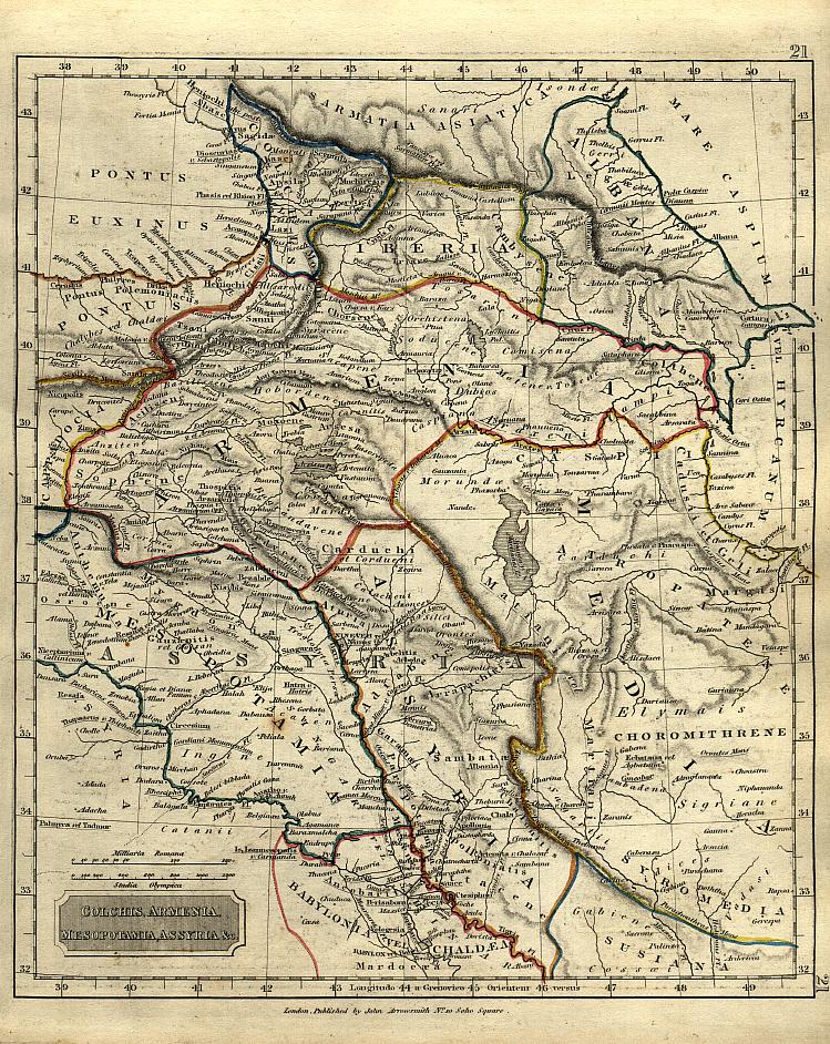
Harry Anastopulos: I found this map interesting because it chops up the area widely known as "Mesopotamia" and makes certain distinctions between many of the areas inhabited by peoples of ancient times. Yet other maps assign labels like "Mesopotamia", "Fertile Crescent", and others differently. This map apparently indicates that "Mesopotamia" means Upper Mesopotamia, although we've certainly talked about Mesopotamia in the context of describing only Lower Mesopotamia. It also demarcates Babylonia from the rest of the so-called Fertile Crescent, while claiming that Assyria is part of "Mesopotamia" proper. This map is completely choked with millions of names that range from easily recognizable to the more esoteric. There are also places like "Iberia" and "Chaldea" that I've never heard of...I feel as if different names depend on who's making the map, which added to more of my confusion. I believe this map and others like it are indicative of the ensuing confusion that comes from the plethora of different Western (and Eastern, I suppose) labels for the Mesopotamian region.
Image credit: http://www.geocities.com/master8885/Maps/cama_1840.jpg
Posted at Sep 17/2006 11:26PM:
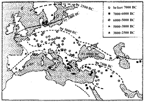
Juliana McKittrick: This map depicts the dispersion of crops from the Fertile Crescent, namely emmer wheat and barley, to Western Europe. The symbols mark sites at which agricultural remains have been found (I wish it was easier to read). The dates were derived from radio-carbon dating. Considering the class discussions on Euro-centrism, I find this map quite interesting. There are no labels of place names, avoiding a major point of controversy. The map is Euro-centric in that it shows Mesopotamia’s influence on Europe exclusively. Although it is a limited example, I think the map does a good job of showing the importance of Mesopotamian agriculture.
Image Credit: http://www.knowth.com/anthropology.htm
Posted at Sep 18/2006 01:37AM:Rafael Rincon
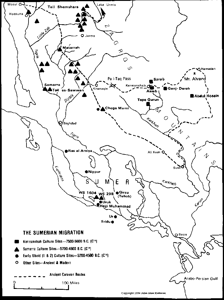
This map depicts various Sumerian Neolithic and Chalcolithic archeological sites. The oldest sites (7500-5600 BC) are the Kermanshah Cultural sites followed by the Samarra culture sites (5700-4900) and the Early Ubaid Culture sites (5200-4500 BC). The different cultures are represented with rectangles, triangles, and circles respectively. It is interesting to note that a large proportion of the Sammara culture sites are situated along the ancient caravan routes. This finding might suggest the importance of communication and trade between the peoples of these ancient settlements.
Image Credit: http://www.sumerian.org/map.htm
Posted at Sep 18/2006 09:05AM:
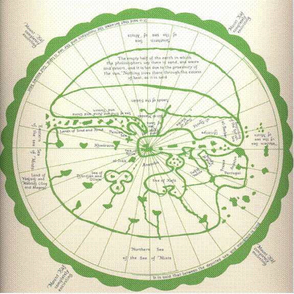
Madeleine Andersen: This map is from the World Sketch in the Sea-Atlas of Ahmad al-Sharfi of Sfax (C.E. 1571/72). It is a non-scalar representation of (what I assume to be) navigable seas and surrounding lands. The map charts territory from Portugal to Iraq. Just below the center point of the map is Anatolia. I’m guessing that the forked lines just “south” of that are meant to depict the Tigris and the Euphrates. The text at the top of the map, which refers to the deserts of the Sudan, reads “The empty hall of the earth in which the philosophers say there is sand, and waste and desert, and it is hot due to the proximity of the sun. ‘Nothing lives there through the excess of heat, as it is said.’” The maps serves not only as a geographic (albeit, non-scalar) representation, but also as a source of geological and perhaps even philosophical thought of the time
Posted at Sep 18/2006 09:10AM:
Image Credit: Transcribed from the World Sketch in the Sea-Atlas of Ahmad al-Sharfi of Sfax (Marsh 294) by courtesy of the Bodleian Library, Oxford
Kennedy, Hugh (editor) "An Historical Atlas of Islam," Boston, 2002.
Omur Harmansah Posted at Sep 22/2006 10:55 AM:
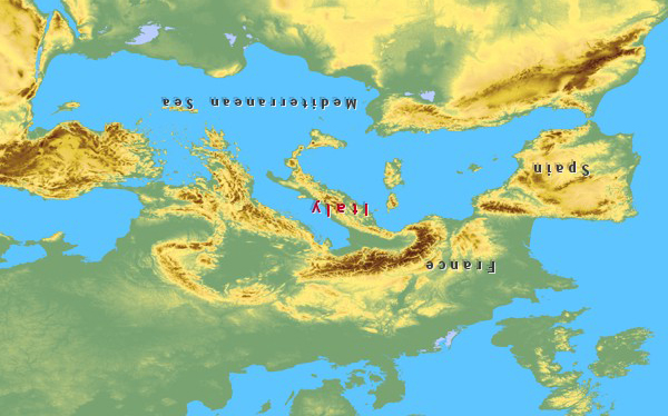
An upside down map of the Mediterranean. Image credit: casa-toscana-ag.com.
