the european tradition |
||||
Maps as graphic representations of spatial relationships and topographic detail are relatively recent in origin. In fact, there was no word in any European language that meant map (as we use the term) until the Renaissance. “Mapa” meant cloth and “carte” or “carta” meant a piece of paper or a letter—in other words, the surface upon which a graphic representation of the earth could be drawn or painted. Before the Renaissance it was primarily artists who depicted geography, drawing or painting landscape in plan with no apparent attention to scale relationships. On the other hand, medieval surveyors usually described property and boundaries by written description alone. In addition to written surveys and painted plans there was also a strong European artistic tradition that recorded elements of landscape with ground-level views and oblique views drawn from a position (or positions) above. Cities and important places were the usual subjects, although this tradition did not place undue emphasis on the accuracy of the rendering |
||||
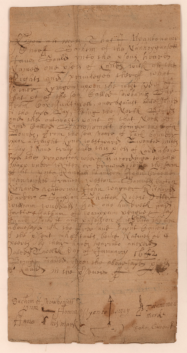 |
1. Miantonomo. [Deed to Warwick, Rhode Island]. Ye twelth[sic] day of January 1642. Manuscript. This deed to Warwick, Rhode Island, territory that was conveyed to the English colonists by the Narragansett Indian sachem Miantonomo, is an example of the longstanding tradition of written geographical description that continues to this day in the recording of real estate titles. |
|||
| 2. “[German towns of the Holy Roman Empire].” In: Hartmann Schedel, Das Buch der Chroniken und Geschichten. Nuremburg, 1493. The woodcut shown here is an entire landscape of so-called bird’s eye views of towns that the artist has joined together with rivers and streams to form a “map-like” representation of the German portion of the Holy Roman Empire. There is no scale or single perspective, the location of the towns in the picture has nothing to do with real geographic relationships, and the images of the towns themselves are fanciful. It does, however, make a recognizable “cartographic” statement. |
||||
| CLAUDIUS PTOLEMY (fl. 2nd c. BCE) | ||||
 |
Geographical works by the Alexandrian astronomer Claudius Ptolemy had been translated into Latin and began to circulate in European learned circles by the beginning of the fifteenth century. A printed edition of Ptolemy was issued in 1477, not long after Gutenberg’s Bibles, reaching out to a Renaissance audience that had begun to develop a taste for theoretical and practical geography. Whether Ptolemy’s original work actually contained maps—or just the directions to make them—is an open question, for the maps that accompanied his text by the Renaissance could have been drawn and added at any time. But, most importantly, Ptolemy’s “new” way of looking at the world was based upon the representation of landscape by a drawing to uniform scale; this was the major factor that was to shape the development of western mapping. | |||
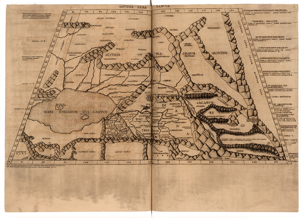 |
3. “[Spain].” In: Claudius Ptolemy. Cosmographia. Bologna, 1477. 4. “Septima Asia Tabula.” In: Claudius Ptolemy. Cosmographia. Rome, 1478. In his writings Ptolemy made a distinction between “geographic” regional maps, where features were shown simply by lines and dots (no. 3), and “chorographic” maps, which were large-scale maps of smaller areas that made some use of pictorial elements (4). |
|||
| Exhibition prepared by susan danforth. on view in the reading room from January 27 to april 23, 2010 |