MAPs to process geographical information |
||||
 |
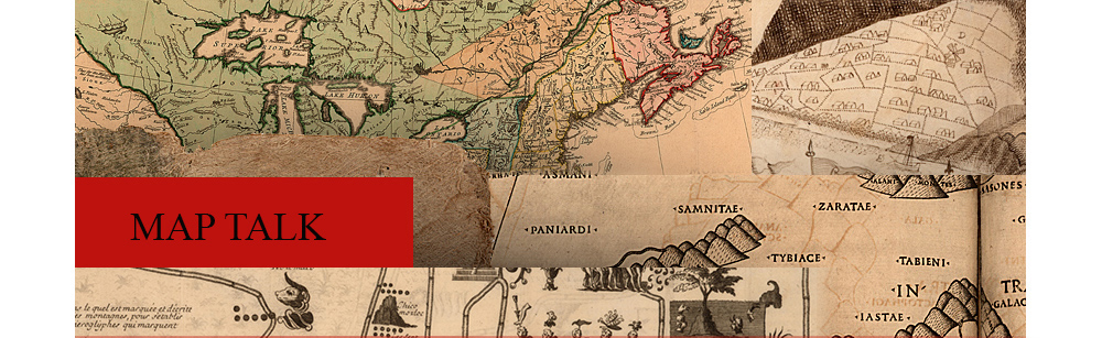
26. “[Newfoundland and the surrounding area].” From: [The Blathwayt Atlas. London, ca. 1683]. This map is derived from the direct experience of Englishmen who seasonally fished the Grand Banks, drying and salting their catch on the Newfoundland shore before loading it onto ships for the voyage home. The Eastern coast of the island is drawn on a larger scale and with more detail than the west because it was the chief focus of English fishing interests. The fishermen erected seasonal camps on the coast and had little experience of the interior. |
|||
 |
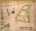
27. “Virginia.” In: John Smith. The Generall historie of Virginia, New=England, and the Summer Isles. London, 1631. During the early settlement period, most European knowledge of the interior of the continent was obtained from Native Americans. Many misconceptions about the geographical nature of North America on old maps were often the result of imperfect communication between the two groups or, sometimes, of calculated “misinformation” supplied by Native Americans. As explained by the key at the upper right, the limit of the colonists’ first-hand knowledge is indicated by a cross. The remainder is derived primarily from interviews with Indians who lived in the area. Archeological excavations have confirmed much of Smith’s cartography. |
|||
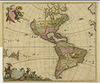 |
28.Frederick de Wit. Novissima et accuratissima septentrionalis ac meridionalis Americae. Amsterdam, [ca. 1699]. The depiction of California as an island is probably due to Father Antonio Ascension’s misunderstanding of the reports of the Spanish navigators Juan de Fuca (1592) and Martin d’Aguilar (1602), which seemed to suggest the possibility of an opening in the west coast and an inland sea to the north. In 1620, Father Ascension drew a map that illustrated his concept of an insular California and dispatched it to Spain, but the ship was captured by the Dutch and taken to Amsterdam. Two years later maps were being published in Amsterdam showing the island of California, and this idea lodged in the European imagination for more than a century. Even though Father Eusebio Francisco Kino’s explorations in 1698 proved that California was a peninsula, it was not until Father Consag sailed completely around the Gulf of California that Ferdinand VI of Spain issued a royal decree in 1747 stating that California was not an island. |
|||
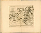 |
29. “Carte générale des decouvertes de l’Amiral de Fonte.” In: Guillaume Delisle. Nouvelle cartes. Paris, 1753. The “Bartolomé Font” northwest coast geography was a hoax, but no one has yet come up with an answer as to who perpetrated it or why. It began in 1744 when a letter was published in England that claimed to be a translation of an official Spanish report by one Admiral Bartolomé Font. In it Font claimed that he had made a voyage from Hudson’s Bay to the Pacific Ocean by way of a convenient cross-continental passage. Along the way he had even encountered a Boston fur trading ship owned by a man named Shapley. Nobody was ever able to locate or corroborate the original Spanish report, but the story inspired an intense, though short-lived, flurry of cartographic speculation. |
|||
| Exhibition prepared by susan danforth. on view in the reading room from January 27 to april 23, 2010 |