Maps are not territories, as the Polish-American philosopher Alfred Korzybski argued: they give away the mentalities, ideologies of their (map)makers. Using the web-image search engines or library resources, locate a curious map of the Middle East and write a (minimum 300 word) commentary about it highlighting the ways in which the geography of Middle East is represented in it. This can be a contemporary map, a satellite image, a historical map, a city plan, a hand drawn map etc. anything that is some form of a cartographic representation of the Middle East or a part of it. The goal is to challenge the idea of a map as a representation of a geographical reality and unpack the political discourses behind them. Post your map and your paragraph(s) below on this page. Please make sure that your image size do not exceed 750 pixels in width and provide an image credit (reference to the source of your image).
Due: February 2 Thursday before class (to be posted on the wiki below)
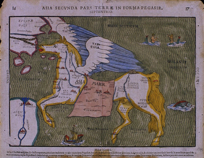 "Heinrich Bunting’s 1594 “Map of Asia in the shape of a winged horse.”
(Image source: Yale University Libraries Map Collection)
Here is my map very interesting
Müge :
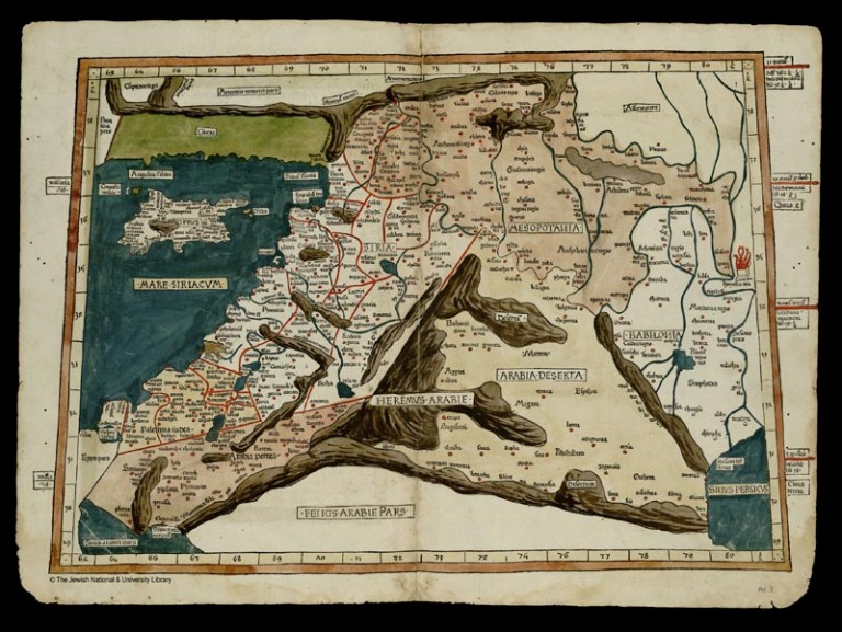
"Quarta Asiae taubla continet Cyprum & Syrium & Iudea & Vtraq. Arabia petream & deserta ac Mesopotamia & Babilonia" by Ptolemy, 2nd cent ADImage source: "Holy Land Maps" (http://www.jnul.huji.ac.il/dl/maps/pal/html)
This map of the Near East was drawn by Ptolemy in the 2nd century AD. The depiction is dominated by the mountain ranges, which are rendered in three dimensions as opposed to the rest of the map. The whole geography seems a little bit “tilted”, and everything is rendered in a more elongated fashion than they actually are.
Ptolemy was a Roman citizen in Egypt, and I am wondering if this played into the mechanics of the map. The geography looks as if it is being looked at from below, which is the reason why the proportions are not as accurate as they should be. Furthermore, the exaggeration of the mountain ranges suggest an unfamiliarity with such kind of landscape.
My personal favorite in this map is the rendering of Cilicia, which is bounded by mountains with no passes on two sides, while it appears as a huge rectangle and the only green spot on the map. Cilicia was well known to the Roman world, perhaps more than most places on this map, which could account for the emphasis. Before Ptolemy’s time, Pompey the Magnus defeated Cilician pirates in 67 BC, while the region continued to be an important nexus for the rise and spread of Christianity.
For me, this “curious map of the Near East” shows how personal attachments, knowledge and ties to space play into the practices of map making. During the process, we are bound by what we know from our surrounding geography. At the same time, the places where we can associate with events can take on different meanings and renderings, as the example of Cilicia suggests.
Nick Bartos:
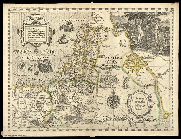
"Tabula Terrae promissionis haec est, & progressionis filiorum Israel, atque Gan-eden Seu Paradisi delineatio, Secundum sacram scripturam" by Abraham Ortelius, 1586. Image Source: "Holy Land Maps" (http://www.jnul.huji.ac.il/dl/maps/pal/html/eng/pal002369199.htm)
This map of the Near East, drawn by the Dutch cartographer Abraham Ortelius in 1586, focuses on the modern Egyptian, Israeli, and Lebanese coasts. While the map especially highlights natural barriers such as rivers and mountains by rendering them in three-dimensions, the religious connotations of the map are perhaps most apparent. The statement on the upper left proclaims the image to be of the “Terrae promissionis” (the Promise Land), connecting the region with the “Gan-eden Sua Paradisi” (the Garden of Eden, Their Paradise). This concept is again reflected in the large sketch of Adam and Eve in the upper right corner.
Likewise, the explicit link between events, whether historical or mythological, and the physical landscape is also quite prominent. For example, the most southern part of Israel depicted in the map is characterized almost exclusively by the presence of large armies and a battle scene. Other areas are marked by farmers working the fields, large ritual ceremonies, or major fortifications. Also, it is important to note the multiple languages on this particular map. The majority of the writing and place names are in Latin, but some of the descriptions around the illustrations are in Dutch. This is of course a function of the cartographer, Oretelius, who had knowledge of multiple classic and modern languages.
This particular map fits into our working definition of a “curious map” because of its unique emphases. The clear Christian association both in the title and the illustrations demonstrate a religious agenda as expressed through the landscape. The map also serves as more of a cultural or historical navigation through the region rather than a strict geographic guideline. Details about city placement, etc. are sacrificed for the illustration of historical and mythological events. The map therefore serves as an exercise in land association and memory with regions of the Near East simply characterized by this singularity. Yet, as I noted above, major barriers such as rivers and mountains are still highly prominent, suggesting that the interplay between the landscape and these events (i.e. why these events happened where they did) is also of concern.
---
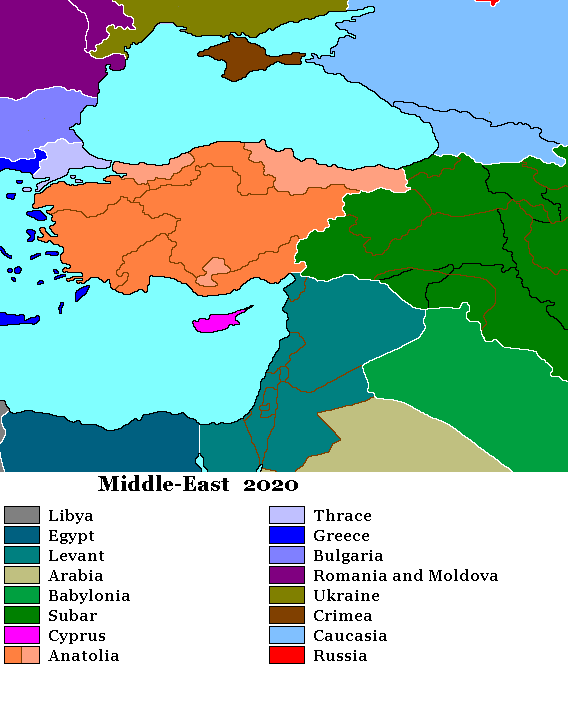
This map is a computer generated snapshot of what I assume to be a larger world map under constant edit by an online persona "Darkseid". I found this in a forum talking about the future of the Kurdish people the original spark for the argument was someone mentioning that diverse nature of the Kurds themselves. Eventually Darkseid joins the conversation by showing off his future map of the Middle East. He is met by a range of praise and criticism which he deflects by changing the map a few times to address concerns.
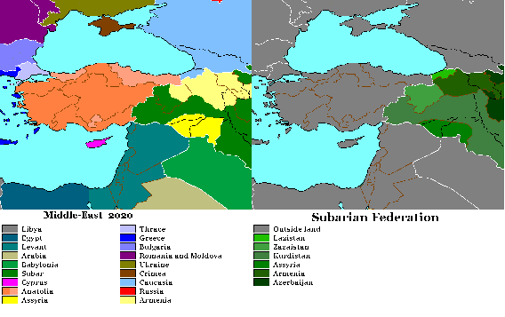
I find these maps so interesting because they represent an attempt by modern peoples at least somewhat invested in the process either through family history of casual (not-so casual) interest. Yet in many ways they are repeating the methods (but not the aims) of colonial powers a century ago. Darkseid's maps as well as others in this particular discussion are thrown out as evidence with little to no context. His own maps are contrasted with other published maps of dubious quality, thus reifying his work in a broader cartographic dialogue. In the end this map represents a "solution" with a dead-line (2020). No mention is made of how and when these changes will occur and the fluidity of the borders within this single conversation represents the impermanence of any design.
As crude as we may see this map it has very specific triggers for members of the affected community. Some of the comments on it where in relation to very minute places undetectable on the map. These places loomed large in the critic's mind and prompted them to critique the map as either including or excluding a place name when it should have been the other way around. This points to perhaps an internal perception of what seem to be stark images informed and changed by one's own cultural background. Also interesting is the fact that modern state boundaries are left intact to allow a reader to place these new boundaries in relation to the current reality.
Andy:
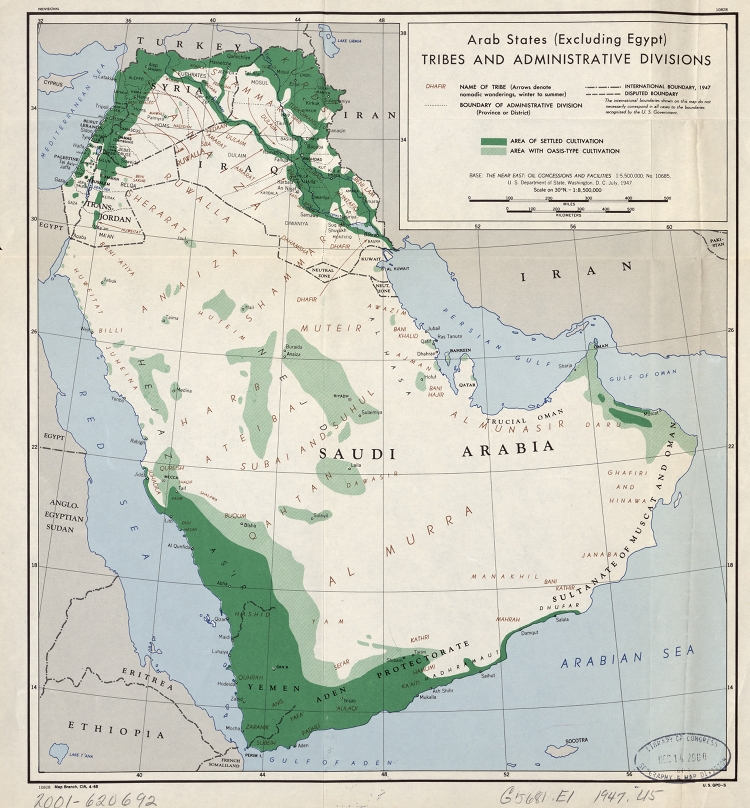
"Arab states (excluding Egypt). Tribes and administrative divisions" CIA Map Branch, 1947 (ImageSource: Library of Congress)
This map of the Middle East was produced by the CIA in the aftermath of the Second World War. The map displays the Arab States (excluding Egypt) broken down by tribal and administrative boundaries.
Although the land mass looks very similar to what we have come to expect on modern maps of the region, there are some obvious differences in political boundaries. Most notably, the state of Israel has yet to be created leaving Palestine in its place. Neutral zones are recorded between Iraq and Kuwait. No national boundaries are recorded for the modern states of Oman, Yemen, Saudi Arabia, Qatar, Bahrain, or the United Arab Emirates.
In addition to the above, the focus of the map on areas of 'settled civilization' (dark green) shows the importance of the Rivers Tigris and Euphrates and the Mediterranean coast in supporting more substantial populations. However this focus on the 'civilized' also implies many of the transhumant tribes of the Middle East occupy a sub-civilized level. Arrows tracing the seasonal migrations, or 'nomadic wanderings', of tribal groups in Syria and Iraq show these tribes moving to more hospitable lands in the summer months.
Most interestingly, the tribal divisions and migrations illustrated on this map are seen to not correspond at all with modern political boundaries. Many of the recorded tribes exist across several states, and seasonal migration routes in the north in some cases cross through two or three national borders. This 'curious map' serves to highlight that Western concepts of the Middle East have been formed only in the latter half of the 20th century, and that many modern states exist independently of the tribal groups living in the region.
___
Susan:
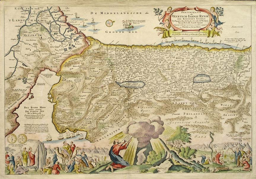
“PerigeinatieVeertich-Iarige Reyse Der Kinderen Israels” was produced by Jacob Keurs inAmsterdam in 1702. Image source: RareOld Maps of The Middle East, by Grace Galleries of Harpswell, Maine (http://www.gracegalleries.com/MiddleEast_Listings.htm).
This map ofthe Near East portrays Palestine. The Mediterraneanand Red Sea coasts are decorated with sailboats and the map identifies a numberof place names, lakes and rivers. Regions are segregated by colored borders and mountainous areas aredepicted with a series of rounded mounds. However, it is the interplay of the map with its religious images thatis the main emphasis of the piece.
I had found anumber of maps of the Near East that separated the land by the regions of thetwelve tribes of Israel. While this mapdoes not specify the twelve tribes, it does make mention to “der KinderenIsraels,” or the children of Israel, in its cartouche in the upper right. This “curious map of the Near East” isparticularly interesting because of its religious imagery. The illustration at the bottom of the mapportrays different events of the Exodus with the central image showing Mosesreceiving the “Tablets of Law.” Unlikethe other maps I had seen, in which tribe names were just overlaid on the mapitself, this map withdraws the blatant religious agenda from the map part ofthe map and has the Exodus story spill out from its center. There is no clear line drawn between the mapand the images. Is this to emphasize aconnection between the land and the people? The main point of separation is the omnipotent cloud from which Moses isreceiving the tablets and from which rays appear to be shooting out onto themountainous landscape. Also, I wonder ifthe inclusion of the sailboats is to indicate seas or do they serve a greaterpurpose? Is their inclusion to emphasizethe idea of movement perhaps… playing into the Exodus theme?
