June 2009
Secrets of the Sea
by Steve Mentz
The Orinoco and the Sea
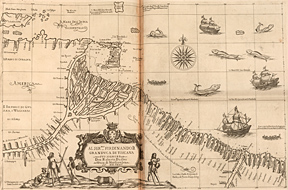
Carta particolare della costa di Guiana, Sir Robert Dudley, Dell’arcano del mare, Florence, 1661 |

Image from the collections of the
John Carter Brown Library.
Not to be reproduced without permission.
|
|
What are the “secrets of the sea?” As early modern European culture expanded across oceans, the mysteries of the deep became increasingly important. Beyond the many shocks of the New World, the experience of crossing and recrossing the sea disoriented early modern European culture and displaced many of its accepted ideas about the natural world. One of the greatest surviving textual and visual monuments to England’s growing engagement with the maritime world is Robert Dudley’s maritime atlas, Dell’arcano del mare (“The Secrets of the Sea”), first published in Florence in 1646-8, and then again in 1661. (The JCB has copies of both editions.)
This massive and beautiful book claims in its title to reveal the mysteries of the sea. The first real rival to the Dutch atlases of Mercator, Ortelius, and Blaeu, the Arcano represents a high-water mark of seventeenth-century English cartography. It is the first printed atlas made by an Englishman, although the text is in Italian and Dudley lived in Florence when he made it. It is also the first world atlas to use Mercator projections for all its maps. Sometimes described as the “most sumptuous [atlas] ever produced,” the Arcano contains engravings by the Italian master Antonio Francesco Lucini, who claimed to have used 5000 pounds of copper for the plates. The carefully detailed maps in the atlas impose visual order on the chaotic maritime world, including such technical details as sounding depths, prevailing winds, ocean currents, and observed compass variation.
The lavish volumes of the Arcano also capture the idiosyncratic vision and energy of Robert Dudley himself, an experienced mariner, frustrated courtier, displaced Duke, and exiled heir. Born as the illegitimate (but acknowledged) son of Elizabeth’s favorite, the Earl of Leicester, Dudley was a notable figure in Elizabethan maritime expansion. He sailed to Guiana in 1594-5, passing near to Bermuda on his way home, where, in an encounter he wrote up for Hakluyt’s 1598 Principal Navigations, he failed to ambush the Spanish treasure fleet. He exploited his family and social connections to mariners like Francis Drake, Henry Hudson, and his brother-in-law Thomas Cavendish. His larger ambitions were stymied after he became embroiled in litigation in 1605 over his right to the title of Duke of Northumberland. After failing to secure the title for himself, he abandoned his wife, Alice Dudley, and fled to Florence with Elizabeth Southwell, his second cousin and soon his new wife, who was apparently disguised as his page.
Dudley lived in Florence for the rest of his life, unsuccessfully negotiating his possible return to England while serving various Medici Dukes. He drafted the manuscript atlas that would become the Arcano around 1636 (the original now resides in Munich), and the first edition appeared in 1646. The JCB is one of only two libraries with copies of both editions of the Arcano (the other pair is down the shoreline at Yale). The JCB copy of the 1646 edition has a Medici stamp on its armorial binding, indicating that this volume belonged to Cosimo III, who became Duke in 1670. Cosimo was not, however, the Duke who received the dedication of the Arcano; the page is missing in the JCB’s 1646 edition, but the 1661 second edition contains the dedication to Ferdinand II, who preceded Cosimo III as Duke, and who confirmed Dudley’s claim to be Duke of Northumberland (not that the Florentine’s approval swayed the English courts).
The page pictured here, taken from the 1661 second edition, shows the coast of Guiana and the mouth of the Orinoco River. It epitomizes Dudley’s efforts to make the maritime world comprehensible. The detailed images of the Orinoco basin suggest a level of precise knowledge about this delta that probably exceeds what any European navigator knew about the area (though Dudley had been there in 1594-5). The soundings given for the mouth of the river and along the coast make the unfamiliar area appear accessible to foreign mariners. The coastline itself appears legible and clear, though no details of the interior are indicated. In the center bottom of the image, a crest dedicates the map to Ferdinand II, Grand Duke of Tuscany, and also reiterates Dudley’s claim to be Duke of Northumberland. The crest presides over an image of South American exotica, including an armadillo and a native family (described as Ewiapanomi, a name perhaps drawn from Raleigh’s Discovery of Guiana, though the natives pictured here lack the eyes in their shoulders and mouths in their breasts that Raleigh described). Despite its cartographic precision and emblematic symbolism, however, this representation of the sea retains some mystery. In the upper center and right of the image, the ocean teems with monster-sized fish that outnumber the pictured ships five to three. Just off center, a compass rose orients the viewer. Dudley’s map surrounds the knowable shoreline with an unknown interior and unknowable ocean. It provides a clear image of the challenge and promise the maritime world posed to early modern European culture.
|