

In 2000 Brown University sponsored these excavations with generous subventions from the Luther I. Replogle Foundation, the Halmos Family Foundation, the Manchester Growth Fund, and Brown University Alumni Awards and Honoraria. Before discussing each of these excavations, credit must be given to the 2000 staff.
The Brown University Staff was comprised of Artemis A. A. W. Joukowsky, Photographer and Administrator; Brian A. Brown, Assistant Director, Surveyor, and Archaeologist, Archaeologists Adam M. Brin, Patricia W. Farley, Steven J. Larsen, Erin E. McCracken, Karen B. Stern; and John P. Hagen, artist, Deirdre G. Barrett, Catalog and Artifact Registry, and Ueli Bellwald, wall painting and architectural fragment restoration. Sara G. Karz, Senior Archaeologist, not only excavated the Great Temple, but investigated the Small Temple complex, which lies to the west of the Great Temple.Our gratitude for the success of this season goes to Dr. Fawwaz al-Khraysheh, Director of the Jordanian Department of Antiquities. Sami Al-Nawafleh ably served as the Jordanian Department of Antiquities Representative, and Mohammad Abdul Aziz al-Marahaleh, represented the Petra Museum. Dr. Talal Akasheh and Fawwaz Ishakat of the Royal Jordanian Geographic Center of Hashemite University, and Pierre and Patricia Bikai of the American Center for Oriental Research were also instrumental to this seasons research. For the seventh consecutive year, Dakhilallah Qublan served as our Foreman and is in charge of the sites consolidation and preservation.
Using the Total Station, we converted all of our data to Global Positioning Satellite technology. These data are presented in Universal Transverse Measurements grid coordinates. Our previously collected data, accurate within itself, have now been corrected with an addition of 19.556 m to our previously published elevations. This shared data for the Petra Mapping Project, sponsored by the American Center for Oriental Research and undertaken by the Hashemite University, will allow researchers a plan of central Petra with sub-centimeter accuracy.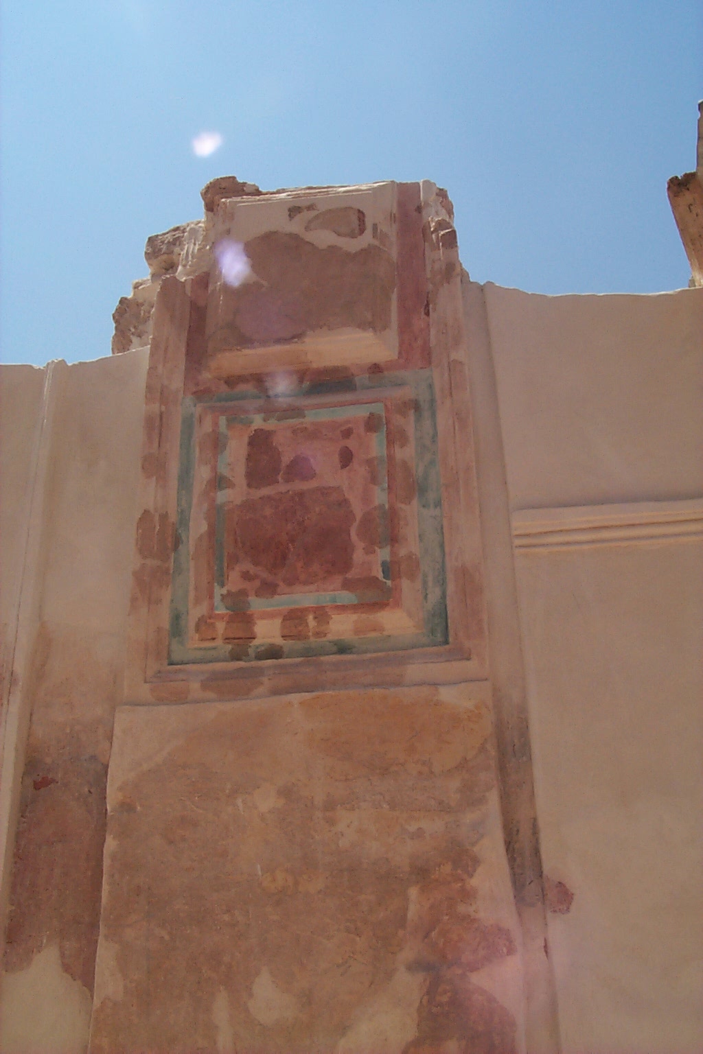 |
| Plaster restoration on the western corridor wall |
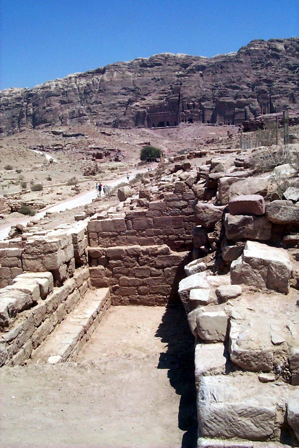 |
| Trenchs 69 and 70 at the end of the season. |
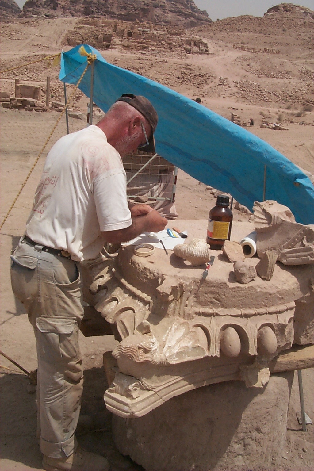 |
| Ueli Bellwald restoring one of the elephant headed capitals |
 |
| The doorway. now completely uncovered, in the eastern perimeter wall |
Two trenches, Trenches 69 and 70 and Special Project 70, (Fig. 5) were excavated from the west of the stairs to the cut left from the excavation of the so-called Baths. Under the supervision of Steven Larson, Brian A. Brown and Elizabeth Smolenski, the full east west extent of this cryptoporticus was exposed measuring 24 m. A sub flooring for robbed out pavers was found at an approximate depth of 4.53 m on the east side of this trench, but further excavation here in 2001will confirm if in fact this is the earliest flooring. It also remains unclear if the west cryptoporticus was at some point remodeled in a later period for shops along the Colonnaded Street.
Most spectacular have been the 2000 Propylaeum discoveries of limestone capitals sculpted with Asian elephant-heads. Over the eight years of excavation we have cataloged 328 elephant head elements, and in 2000 we recovered two complete capitals lying under collapsed columns, clearly indicating that both the Propylaeum and the Lower Temenos colonnades were decorated with these elaborately carved capitals. Several capitals were recovered and restoredone capital that adorned an engaged column is pictured in Fig. 6, as well as one with four headsand was moved to the entry of the Petra Museum. Also recovered from the Propylaeum during the 2000 excavations was a horned altar. Fig. 7 shows the altar in situ.
To the east and west of the Lower Temenos are triple colonnades on the east and west, with a total of 120 columns (60 on each side). These colonnades led into imposing east and west semi-circular buttressed exedrae. Between the colonnades and coeval to them there is the sweep of an enormous plaza, approximately 55.00 m in length and width, laid with large hexagonal pavers, constructed at the same time as the colonnades.In Trench 71 2000, measuring 26 m-by-13 m, supervised by Martha Sharp Joukowsky, the upper levels were excavated of a double parallel vaulted cryptoporticus located below the West Triple Colonnade (Fig. 8). Here a double cryptoporticus has been exposed to extend north from a massive stepped east west retaining wall found under the West Colonnade below the fifth column to the north of the West Exedra. We reasoned that the east west Propylaeum cryptoporticus turns to the south and extends under the triple colonnadethe visible decorative border of the Lower Temenos leading to the West Exedra. Although partially excavated, to an approximate 1.58 m depth below the stepped east west retaining wall, it can be projected that this western cryptoporticus measures some 44 m in length-by-approximately 12 m in widththe width of the Triple Colonnade. Further excavation will be necessary to confirm the relationship between the Propylaeum and the Lower Temenos architecture.
The west wall of the cryptoporticus was constructed with sandstone and sometimes limestone ashlars averaging 0.50 to 0.55m in length-by- 0.21 to 0.32 m in width set with white mortarwell dressed arch springers and voussoirs extend from the parent wall itself. These connected with centrally placed piers with arch springers on both sides, which in turn connected with the east wall.
Found in the collapse of the trench were large rectangular limestone blocks (1.10 m in length-by 0.60 m in width-by-18 m in thickness), which originally covered the cryptoportico arches. Other artifacts of interest discovered in Trench 71 comprise seven partial inscriptions (one is shown in Fig. 9) and a worn but complete elephant-headed capital, plus a battered smaller elephant-headed capital with a diameter of 0.48 m; which originally may have been placed on one the West Exedra entry columns. Most likely the exedrae entry columns were decorated in a fashion similar to the colonnades, but with smaller elephant-headed capitals.
The discoveries made in 2000 have helped us clarify the relationship between the cryptoporticoes and the West Triple Colonnade. Circumstantial evidence is in favor of assigning both of these building programs to the same but consecutive architectonic design. Confirmation of the construction of the double cryptoporticoesnamely, the north south piers and arch springersrun underneath the Lower Temenos Hexagonal Pavement constitutes a significant element in the solution of this building program. Also, the discovery that the stepped east west retaining wall theorized in our earlier phasing exercises to be a later response to earthquake, in fact, represents one the earliest elements placed possibly across the Lower Temenos, and further strengthens the theory that this was part of the original plan to build up the Lower Temenos, so that the Hexagonal Pavement and Triple Colonnade with elephant-headed capitals would be given sufficient support. Finally, the recognition that the construction techniques and materials combined with the industrial reuse of the area and the Bedouin haphazard coursing and construction techniques over various parts of the area, including the staircase and the Byzantine Platform positioned in front of the West Exedra (Joukowsky 1998 Figs. 5.21, 5.10), further suggests that these activities represent later architectural phases.The excavations of 2000 resulted in a wealth of new information concerning the enigmatic Lower Temenos installations. While no sealed deposit was found which might help us with phasing and absolute dating, there is a great deal of evidence relating to Phase I Great Temple construction. A number of discoveries were made which were of some significance including the interrelationship between the Lower Temenos Hexagonal Pavement, the Western Triple Colonnade and the double vaulted cryptoporticoes.
First and foremost, the upper level exposure of the extant West Triple Colonnade confirmed our hypotheses concerning the symmetrical arrangement of the Lower Temenos, and the extent of symmetrical influences in its design and construction. Also, theories regarding the relative phasing of the West Triple Colonnade as contemporary with the cryptoporticoes were confirmed. Of interest as well is that the build up of the Lower Temenos from the stepped east west retaining wall to the Propylaeum was a massive undertaking for and part of a master Nabataean architectural plan.
Lastly, the Trench 71 excavations of the 2000 season contributed to our understanding of the later reuse phases of the Lower Temenos. Namely, the discovery of the massive burning activities show that later on the Lower Temenos west continued to be used in an industrial way, complementing previous evidence such as the lime kiln in the East Exedra of the Lower Temenos, which was recognized as early as 1995. Somewhat later Bedouin activities took place in the area, so its area use pattern was again modified. All in all, this area can be considered a prime candidate for further exploration and interpretation.
Upper Temenos
The 2000 excavations in the Upper Temenos saw a sondage on the west, beyond and to the west of the West Walkway Wall in Trench 76. On the east there was the removal of the balk to the west of the East Perimeter Wall, and the massive clearance of what we call the plaza surround of the monumental building to its east and south. After giving a brief description of Trench 76 in the west, we will move to the east with a description of the plaza excavation.
Test Trench 76 was opened by P. W. Farley, J. W. Farley, and E. E. McCracken. The trench located immediately west and perpendicular to the West Walkways western wall, measured 11.00 m east west-by-3.00 m north south, to an approximate depth of 1.78 m. The mission for initiating the excavation of Trench 76 was threefold: to locate, further expose, and delineate an outer west wall on the Upper Temenos; to locate and expose a western colonnade if one should exist; and to remove sequential horizontal layers of the trench in 0.25 m increments until sterile soil was reached. It was projected that the potential depth could reach 7.00 to 8.00 m.
Work began with the rediscovery of evidence of canalization in the form of a plaster-enclosed pipe extending along that section of the far western wall. As excavation progressed the trench was filled with the collapse of many large boulders as well as many more ashlars. When it became obvious that the collapse wall debris would continue up to the western border of Trench 76, it was decided to close this sondage. What was determined from this deposit was that the West Walkway Wall had at one time in antiquity collapsed and had completely congested the area between the West Walkway and the far west wall with its canalization.
Artifacts included many Special Finds, including complete Nabataean ceramicsa small bowl, which can be dated to 100 CE (Schmid Abb. 97, Phase 3a-c, Group 8 Abb. 57 or 58) and a juglet (Schmid Phase 2a, Abb.288, dated to 50 BCE to 20 CE). The head of a figurine of a bearded man was also cataloged. Lamps included those from the Nabataean, Roman and Byzantine periods. Large amounts of stucco and several architectural fragments were also found: a pine cone and acanthus leaf, a corner volute, and stucco egg and dart, wave patterns, acanthus leaves and vines, and multicolored segments. Larger amounts of tesserae appeared, along with a kohl liner/pin of worked bone. From the artifact repertoire, it would appear that at some point in the Roman-Byzantine period, this area saw wall collapse and also was used as a dump.
In 2000, concentrating on the clearance of the east surround of the Great Temple in Trenches 72, 74, 75, and 77, one of most remarkable and yet time-consuming excavations is that of Trench 77, supervised in different sectors by E. E. McCracken, A.W. Joukowsky, M. S. Joukowsky, and S. G. Karz. This area encompasses the southeast of the South and East Perimeter Walls, the doorway and arch in the East Perimeter Wall, the great east Plaza, a myriad of canalization systems, the revelation of a cult effigy, and burials. Three phases are recognized in these deposits, from earliest to latest: Phase I: bedrock preparation, the cult image is carved into the south bedrock; East and South Perimeter ashlar walls and subterranean canalization systems are built; Plaza pavement; and the arch and doorway of the East Perimeter Wall are constructed. Phase II represents the modification of the water canalization systems with the limestone channels. Piping, and a secondary canalization and basin near the East Perimeter Wall. Phase III is represented by fill and collapse above the Plaza and the burials. The specifics of each of these findings will be briefly discussed after we cover the mechanics of the excavation.The purpose of Trench 77 excavation was to excavate along the Upper Temenos East Perimeter Wall to determine if it continued to the south. Fig. 10 shows these excavations in progress. A secondary aim of the excavation was to gain a better understanding of the doorway in the East Perimeter Wall, which was first excavated in Trench 68 during the 1999 field season. We also wanted to determine the dimensions of the South Perimeter Wall of the Great Temple Precinct. Further, this excavation was to gain a better understanding of the canalization systems. What was the relationship of this portion of these systems to those systems uncovered in other areas of the Great Temple Precinct? When were these systems constructed and how did they relate to the building of the East Perimeter and South Perimeter Walls?
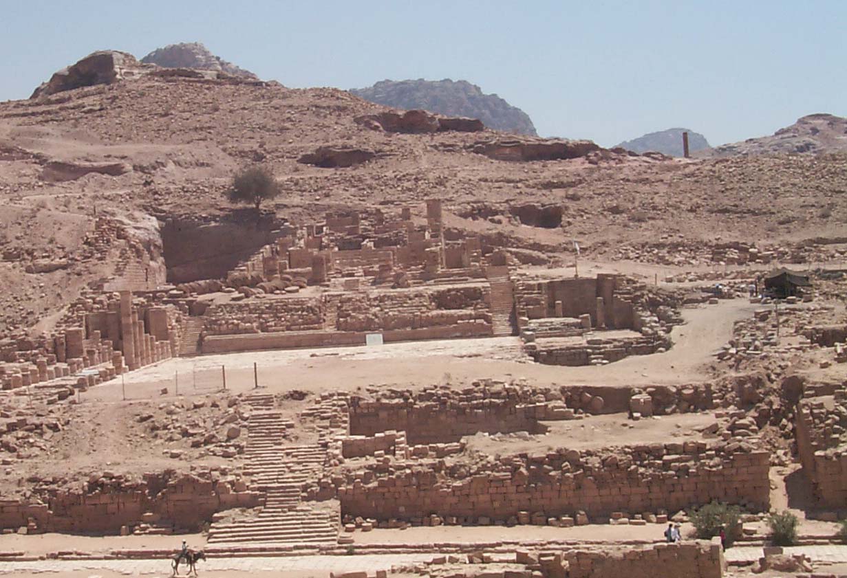 |
| The site, viewed from the Temple of the Winged Lions, at the end of the season. |
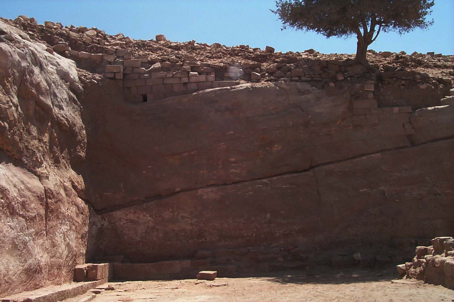 |
| The L-shaped scarp of Bedrock at the south of the Great Temple |
Trench 77 measurements are irregular. Originally, the trench on the east measured 18.40 m north south-by-5.20 m east west. When the South Perimeter Wall was uncovered, we decided to turn to the south and west and excavate it and to follow the natural bedrock outcrop, which added some 21.80 m east west-by-approximately 5.10 m north south. In an intensive survey of the slope beyond and to the south of the South Perimeter Wall, we then uncovered an aboveground canalization system, which was also included in the excavation of this trench. There was a dramatic slope of the overburden in Trench 77 from south to northapproximately 7.30-9.00 m depths were excavated in the south as opposed to 2.50 m in the north. The areas along the East Perimeter Wall, including the burials, and the various canalization systems were excavated by hand. However, much of Trench 77, especially the large amount of overburden and fluvial deposit, was excavated with the aid of mechanical equipment. In summary, this trench extended from the East Perimeter Wall to the west where we assumed the east face of the East Walkway wall would be. In the north its boundary was from the line of bedrock uncovered in Trench 67, 1999 to the south bedrock escarpment. And with its extension, it ranged from the East Perimeter Wall on the south, across the rear of the temple in the west to the north south line of the West Walkway Wall.
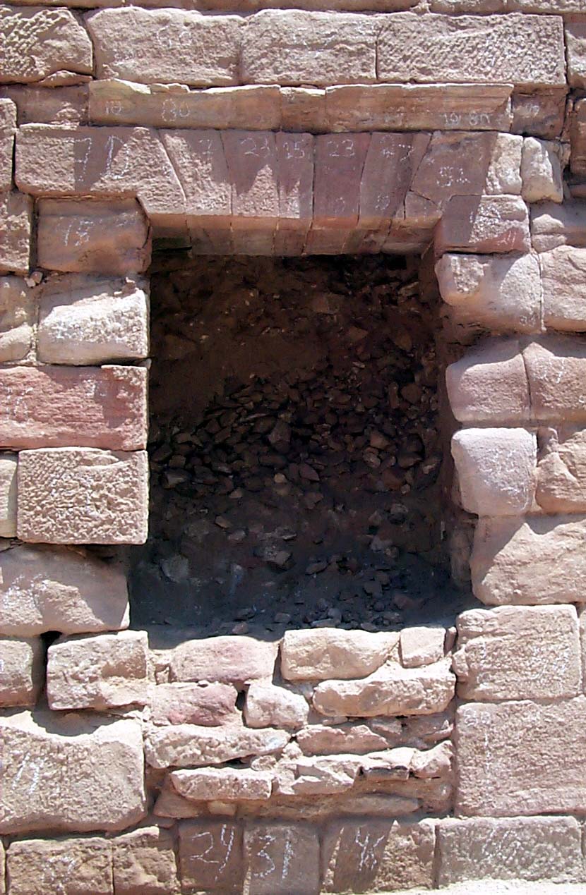
The East Perimeter Wall, shown in Figure 11, defines the eastern perimeter of the Temple Precinct. The most east eastern wall is the highest architectural element of the Great Temple site and is where we had positioned our Site Datum Point which has a measured elevation of 915.036 m, or just 2.73 m above the point we started to clear this area during the excavations of 1999. At the inception of the 2000 excavations, we had to spend some time moving the architectural elements that we had stored in this area for the eventual restoration of the Temple, so that the east Upper Temenos was completely cleared.The East Perimeter Wall with its arch and doorway saw continued excavation and documentation, but because the depth of deposit became significantly greater as we progressed to the south, additional time had to be allotted for soil removal and bulldozer support for the disposal of backfill. Additionally, because the soil was congested with cultural material, ample time had to be allotted for its processing. Yet another consideration was the eventual consolidation and preservation of these delicate walls that stand well over 10.00 m in height and the upper portions of which had been exposed to the elements for 2000 years. This enormous undertaking has been completed.
Surrounded by a 10-11 m high bedrock escarpment faced with ashlars, the East Plaza must have been the venue for the celebration of special occasions. This Plaza measured 45 m north south-by-14 m east west. During the excavations of 2000, the Plaza was cleaned completely to bedrock or to the few rectangular flagstone pavers that were remained and were left in situ. The total measurement from the north end of the East Perimeter Wall to the corner at the South end is 56.10 m in length-by-approximately 10-11 m in height-by-9.53 m in width. An illustration of this area is shown in Fig. 12.
The East and South Perimeter walls were two rows of ashlars built like a veneer to cover the bedrock. The innermost row built against the bedrock was comprised of large irregularly hewn sandstone blocks bonded together with wet mud mortar. Visible from the plaza side and bonded to the inner rows were well-dressed ashlars which bore traces of plaster. Unfortunately all but two of the lowest courses and three or four of the upper courses standing well above the area had been dismantled or collapsed in antiquity.
This Plaza was paved, but just beyond the East Walkway Wall a number of these pavers had post-holes, which could be aligned with the post-holes in the East Walkway and the east face of the East Corridor Wall. Because these pavers extended underneath the East Walkway Wall (see the discussion of Trench 73, infra), and predated this wall, it was suggested that the area served as a great open plaza before the East Walkway Wall was constructed or re-constructed.
In 1999, Trench 68 Locus 4 was assigned to the Doorway in the East Perimeter Wall (shown in Fig. 11), which had been incompletely excavated. Its opening elevation was 906.69 m, and its closing elevation was 905.337 m. The excavated portion of its lintel opening stands 2.10 m above the bedrock and pavement, and it underlies and is bonded to the upper courses East Perimeter Wall. Originally it rested on bedrock and pavement, but a later stone fill, which is not original to its construction, had been clumsily inserted to block up its base. In 2000 we uncovered the remainder of this doorway and found that it to be 1.3 m in width.
This doorway is one of the most beautifully preserved architectural elements of the Great Temple. The top of its architrave is stepped, unlike any other architectural elements found heretofore in the precinct. As it was excavated the north doorjamb and the lintel were found to have been in excellent condition, so following the vertical line of the jamb, in 1999 we tunneled to a 0.30 m depth into its interior to determine its character. Its interior is roofed with well preserved sandstone beams that are in an unusually excellent state of preservation. They are neatly and tightly laid and their expertly crafted blocks of variegated sandstone appear as if they had been just been put into place. It is not at all clear as to where this doorway leadsit may go under and through into the paradeisos or Pleasure Park to the east or it may lead to as yet unknown rooms that look out upon the west Temple Precinct.
The Plaza was also equipped with several types of canalization systems. In the main, the soils ranged from a Munsell strong brown 7.5YR 5/6 to red 2.5YR 6/6, and samples of both the hydraulic plaster which lined these systems and their fill-soils were taken for analysis. Already mentioned is a portion of an above ground system found on the slope above the southwest bedrock extending along the slope from the southwest to the northeast. This was a shallow slab covered canal that directed water into the Upper Temenos south. It has not been determined when this system was constructed or how it connects to other systems.
In the mechanical removal of earth, the Plaza pavement was disturbed, and yet another channel was found extending to the northwest. This deposit has an unpleasant odor, which may indicate that it served for the removal of waste from the area. Hydraulic plaster 0.012 m depth covered the walls. The capstone, which was positioned just below the pavement, was broken and collapsed, but we found that it had been supported on a now eroded ledge cut into the bedrock.In a later phase, there are additional modifications to the water canalizationfor some reason additional systems had to be built into or above the Plaza pavement in the southeast. A series of limestone lined channels are constructed with reused ashlars, which are bonded to the pavement with plaster. One is built of a single course of 10 rows of segmented limestone ashlars measuring 0.67-by-0.06 m. In the east the other segment is of six ashlars also measuring 0.67 m-by-0.06 m.
A channel filled with ceramic piping was found to abut the bedrock subterranean canalization systems in the south and east. This system is makeshift, having been placed originally to extend north south, but for some reason at 2.1 m from the south, it curves and then extends in a fairly straight line to the north. It may have served as a conduit for bringing potable water into the site, or as a rebuilding for the then defunct canalization system. It was backed by crudely cut ashlars that were wet laid and were bonded together with mud mortar and hydraulic plaster. Five ceramic pipes remain in situ, each measuring 0.34 m in length-by-0.10 m in diameter.
The latest of these systems and the most difficult to explain is in the extreme southeast, consisting of a crude basin and platform constructed against the East Perimeter Wall and overlying bedrock. The platform, measuring 2.36 m east west-by-2.65 m north south-by-0.76 m in height, is a composition of small ashlars bonded together with hydraulic cement. To the north of this is a basin cut into bedrock, which possibly is associated with a drainage opening in the Southern Perimeter Wall. The basin has a diameter of 0.72 m and a wall thickness of 0.05 mits depth is 0.40 m. It is composed of a cement composition apparently typical of hydrological material. A small section of lead pipe was uncovered measuring 0.60 m in length-by-0.07 m in diameter. The limestone Plaza pavement at one time was set over this basin, but was damaged in antiquity. It would be of interest to know how these various systems interacted.
The temple was built as tetrastyle in antis. It was constructed of regularly cut ashlars, quarried locally from the Disi sandstone with varying hardness (Paradise 1998). The temple building consists of north south walkways, parallel east and west corridors that on the east and west border the theater in the center. The theater consists of a walled cavea resting on parallel barrel vaulted rooms and vaulted stairways. The rooms appear to constitute storage areas (but this remains a matter of conjecture) and the vaulted stairways give access to the higher upper levels of the theatron. We assume that the Great Temple served in a ritual capacity until a fluvial deposit overwhelmed the area; the general robbing of certain elements, such as flagstones and stair treads followed this event. This occurred some time before May 363 CE, but the cataclysmic 363 CE earthquake brought about the final destruction.The Great Temple had its columns and walls adorned with painted stucco in whites, reds and yellows, which must have had a dramatic impact when set against its rose-red environment. Its porch is tetrastyle in antis with widely spaced central columns at the entrance (the inter-columnar space is some 7.00 m), and a pair of interior porch columns located about 5.00 m to the south. Beyond the columns are elongated anta walls, also resting on carved Attic bases of white limestone, standing 4.50 m to either side of the porch columns. The faÁade and porch columns are approximately 1.50 m in diameter, and are constructed with squat sandstone drums resting on beautifully turned Attic bases of fine white limestone. Reconstructed as approximately 15.00 m in height, these porch columns and antae, plus the elements of the entablature and a (postulated) triangular pediment, hypothetically place the height of the facade to 19.00-20.00 m.
Although there are several building phases, two phases, early and later, are found in the Great Temple architecture. Entrance is gained to the Great Temple by east and west stairways that lead from the Lower to the Upper Temenos. There are then steps on the east and west that were intended to connect the temple forecourt with the walkways. To enter the edifice, a stairway approaches the stylobate beyond which is a broad pronaos (entryway), 6.30 m deep and shaded by the porch columns. In this earliest phase, in passing through the pronaos, the visitor would enter the cella of the structure, surrounded by an elaborate interior colonnade. Eight columns flank the cella walls, and six are at the temple rear; all have diameters of 1.20 m and stand upon turned Attic limestone bases (mirroring those of the porch columns stylistically, but smaller in diameter). The two corner rear columns are double-engaged heart-shaped columns, measuring ca. 1.50 m. Based on the evidence at hand, it seems that the structure is originally designed with an interior peristyle of freestanding columns enclosed by walled side corridors. Then in the later phase when the theater is created, casemate walls are built between the interior columns, a large central arched area is constructed in the rear, and arched entryways and multiple stairways are also constructed.
The walkways and corridors mirror each other and have a north south axis. Although their outer walls are carelessly reconstructed, the walkways are part of the earliest architectural building plan and provide access points to the structure. From the walkways, the corridors of the earliest phase are accessed by three doorways from the walkways on each side (or nine in toto) that lead into the east, west, and south corridors, which, in turn, provide a direct access into the cella in the earliest phase or, in the later phase, into the vaulted stairways leading to the theatron. Common to bath phases, each corridor wooden door opens inward into the corridor through which processions entered the corridors.
The inner corridor walls are, in effect, double casemate walls also built of opus quadratum diagonally dressed headers averaging 0.36 m-by-0.33 m and stretchers averaging 1.38 m-by-0.45 m, and their widths are 1.30 m. (Fig. 13 is a line drawing of the East Corridor Wall.) Constructed in the later phase, they were built to enclose the columns and to provide arched windows, passageways, and on the interior to enclose and give support to the theatron. Most of the courses and rows are joined together with a Nabataean mortar and wet-laid mud. Their foundations are of string courses lying immediately above a course of roughly cut ashlars laid directly on bedrockno foundation ditches are used for wall preparation. The same is true for the flagstone pavers that are either cut to be placed directly on the bedrock or there are flat stones to help level them that are bonded together from with gray-white mortar.
Temple East Corridor and East Walkway Supervised by K. B. Stern and A. M. Brin, Trench 73,2000, was located on the Temple east and extended from the southern end of Trench 64. 1999, to the South Corridor Wall of the Temple. The East Corridor Wall formed the western border of the Trench, and the eastern border extended along the East Walkway. The basic dimensions of Trench 73 were approximately 21 m north south-by-3.60 m east-west. The depth of deposit ranged from 2.50 m in the north to 9.00 m in the south. Throughout the season, we used mechanical equipment to clear much of the fluvial layers and overburden in Trench 73. The northern 5.50 m of the Trench, the three doorways of the East Corridor Wall, and the top and sides of the Wall itself were excavated carefully by hand. Until the last week of excavation, we maintained a 3.60 m east-west balk to control the stratigraphy, 1.00 m south of the North Doorway.
The primary objective for excavating Trench 73 was to uncover the eastern side of the East Corridor Wall and the doorways within the Wall. In addition, we sought to explore whether the East Walkway Wall continued south from its exposed area in Trench 64, 1999. By determining the dimensions of the eastern Walkway Wall, we believed we could calculate the dimensions of the eastern Walkway itself. During the excavation of the East Corridor Wall, we maintained four specific goals: first, to excavate the three doorways of the East Corridor Wall, which led from eastern corridor into the eastern walkway; second, to preserve any plaster still attached to the walls of those doorways; third, to recover any architectural fragments disarticulated by the temples collapse; and fourth, to determine if the architecture of the East Walkway paralleled that of the West Walkway. In addition, we attempted to identify cultural materials in sealed loci. The isolation of such artifacts would enable us to determine the different stages of use for the East Corridor Wall, as well as the terminus post quem for the abandonment, collapse, and possible reuse of the East Walkway area. Furthermore, datable artifacts might indicate the uses of the Walkway itself, as well as elucidate the relationship between the Walkway and other surrounding architectural elements.
The excavation of the 2000 season addressed each of our objectives. Areas of the East Corridor Wall, the East Corridor doorways were unblocked and the East Walkway, and East Walkway Wall were excavated. We recovered artifacts from the primary and secondary collapse of the Upper Temenos. Evidence was recovered for the some of the secondary uses of the East Walkway and the southern portions of the Upper Temenos. Through the recovery of artifacts and architecture, and the understanding of a relationship between the East Walkway and east Perimeter areas, we established that the construction of the East Walkway area does not necessarily parallel that of the West Walkway. The East Walkway 3.67 m in width, and the East Walkway Wall is 0.60 m wide. Measurements from the East Walkway Wall to the East Perimeter Wall are 9.53 mthe width of the Plaza when the East Walkway Wall was in place.
The dating of the architecture of the East Corridor Wall and Doorways, the East Walkway Wall, and the East Walkway, are difficult to determine. Stratigraphy aids our understanding, whereas certain periods of the construction of the area are clear, however, other stages of rebuilding or reuse, however, provide little evidence for the assignation of dates to building phases.
The architectural elements of the East Corridor Wall appear to have been built contemporaneously. With the earliest building phase, the East Corridor Wall is comprised of two abutting walls. Like the West Corridor, these walls are built flush against one another with a 1.30 m width. The eastern side was composed of large, finely dressed limestone ashlars. The western side was composed of more roughly hewn stones, as well as chinking stones. The poor quality of this western wall, in addition to the recovery of many stucco architectural fragments found in Trench 65, 1999, indicate that the western side of the wall was originally plastered. Layers of mud mortar were applied between the two abutting walls to bond these two elements. Each side of the Corridor Wall depended on the other for support.
The three doorways within the East Corridor Wall were built at the same time as the walls themselves. They share similar construction to one another: the interior sides of each doorway bear evenly carved doorjambs on the east side of the doorway and attachment holes for the door. The east sides of the doorways have identical widths of 1.80 m. The limestone thresholds of these doorways show similar, tripartite construction. In the Central and South Doorways, the middle register of the threshold includes two holes for drop locks. The ashlars surrounding these rectilinear doorways, are evenly and deliberately spaced for the doorways themselves.
The installation of the pavement of the East Walkway appears to have followed immediately the building of the East Corridor Wall. Unfortunately, the original parameters and design of the East Walkway remain elusive. The existing Walkway is paved with limestone slabs, and measures 3.60 m east west-by-21 m north south. Unfortunately, little more than one half of the paved walkway remains extant. The relative dating of the East Walkway and the East Walkway Wall is also difficult to determine. Evidence for the relationship between the Walkway and Wall remain inconsistentin the north, the pavers abut, but do not undercut, the extant portions of the wall. In the south, later walls are built on top of the pavers. In addition, four different stages of wall building are discernible. Possibly, the earliest version of the Walkway Wall may have been smaller, and may have only paralleled one portion of the East Corridor Wall. In this case, the pavers originally created an uninterrupted plaza, which extended to the East Perimeter Wall. Later, these pavers may have been removed, and the earliest version of a wall was built in the north. In this case, the earliest phase of the wall would have been built after the Walkway itself. Extant architecture, however, provides no evidence for this. At this stage of excavation, however, it remains difficult to posit a date for the building of the earliest East Walkway Wall. Possibly, the construction of the East Walkway may antedate that of the East Walkway Wall.
Certain modifications of architectural features, however, appear to be contemporaneous. The walkway pavement, the facing of the eastern side of the East Corridor Wall, and the thresholds of the doorways all appear to have been altered simultaneously. Perhaps, a change in the use of the area precipitated a corresponding change in the architecture.
The outer face of the East Corridor Wall had a series rectilinearly cut post holes 0.20 m-by-0.15 m, probably for the insertion of wood beams. These may have supported an awning, a wooden platform or both. Such socket holes were also cut in the flagstone pavement, the wall providing the angle of support required. There were not original to the earliest wall, but were inserted later. This could be reasoned from the fact that the sockets were not located in either wall or floor flagstones in a specific place, like the middle of the stone, but were cut in randomly. This sort of lean-to type structure may have served as a waiting area; it was an after thought dating probably to a later building phase. It was definitely in place before the now existing East Walkway wall was put in place.
These roughly carved post-holes were positioned at regular intervals in the pavement of the East Walkwaythey were placed either where two pavers join, or in the middle of a paver itself. Corresponding post-holes are also extant the eighth course of the East Corridor Wall, providing an east-west axis for the placement of the holes in the floor. Some of these holes have broken, or eroded away, while others, which surround the south and Central doorways, are incised more deeply and evenly. Each hole in the southern section of the East Corridor Wall corresponds to two, evenly placed holes in the walkway. These two holes are also placed at an even distance, on a north-south axis, from each other. Some evidence for the continuation of these postholes along the east west axis also exists in the Plaza beyond the East Walkway Wall. These correspondences between the post-holes in the wall and those in the floor, therefore, indicate the placement of a canopy and possibly a platform, covering this area. The placement of the post holes by the south doorway, and the continuation of these post holes in the Plaza towards the East Perimeter Wall, may indicate the existence of a covered passageway or waiting area, which led from the South Doorway and Plaza. Corresponding passageways may have existed further to the north, but the robbing of the north pavers prevents any verification of this possibility. The exact reason for the post-holes of the East Corridor Wall and the East Walkway remains obscure. The existence of such holes in Trench 77 Plaza, however, provides evidence for contiguous use of these two areas, and for the flow of traffic to and from the Upper Temenos to the East Walkway and the Plaza.
Evidence for the abandonment and destruction of the area remain inconsistent. The central and north walkway, and doorways, appear to have fallen out of use earlier than did the area of the south doorway. After abandonment, soil deposits, with charcoal inclusions, were found in these areas. Instead, no abandonment or general destruction deposits are present in the area east of the south doorway, which indicates it continued to be in use. During the third period of activity in the south, the south doorway was blocked. The walkway south was also sealed. After this time, extensive burning appears to have occurred in the south where there is a massive deposit of tiles, mixed with ash, possibly resulting from a burning of the extant canopy in the south.
What does remain clear, however, is that the periods of reuse of the East Corridor Wall, East Walkway, and East Walkway Wall, occurred in rapid succession. All of these areas, including the four stages of reuse of the East Walkway wall, fell out of use before the initial collapse of the Upper Temenos. Nonetheless, major activity in the Temple appears to have been terminated before the major collapse caused by the earthquake in 363 CE
Temple South
Special Project 72 in Trench 77 was devoted to the South Corridor of the Great Temple. The plan is shown in Fig. 16. Its purpose was to excavate the South Corridor and link it to the East and West Corridors as well as to bring the access outside the South Corridor down to the level of the Corridor and determine if there had been a South Walkway. The rationale was to excavate the heavy overburden that covered both the Inter Columnar Wall of the Temple south and the South Corridor.
Originally the project measured 6.00 m east west-by-3.10 m north south, but was expanded to uncover the upper courses of the south wall and its south face, the South Corridor Wall and its north face and to remove the collapse debris from the South Corridor. The area was congested with the tumble of enormous ashlars, some as large as 1.23 m-by-0.80 m in size. The final measurements for the project were 21.80 m east west-by-4.50 m north south. The depth of deposit removed was 3 m on the inside of the corridor (this corridor has yet to be completely excavatedthere is an approximate 4 m of deposit remaining). What was found was that the South Corridor Wall had three rectilinear doorways (east, central and west) which had been blocked in antiquity. It was not clear if these doorways accessed a paved south walkway, but future excavations will reveal if they do.
81 additional elephant head elements were found in the Propylaeum and in the West Triple Colonnade. Although architectural fragments numbered 875, there were some extraordinary elements added to the repertoire, not the least of which were the elephant-headed capitals (Fig. 6), the Nabataean horned altar (Fig. 7) found in the Propylaeum, and a portable limestone betyl found in the East Corridor, shown in Fig. 17. In collapse and fill of the South Corridor, an outsized marble left hand was recovered (Fig. 18).Also in the West Triple Colonnade cryptoportico area some fragmentary inscriptions were discovered: P R O VI [NCIA] could be read on one (Fig. 9). Other artifacts include partial ceramic human and animal figurines, small Nabataean bowls and one ostracon fragment. Several bone pins and complete lamps (the majority was Nabataean) were catalogued, and there were 24 coins as well as part of the drapery of a figure. Metal artifacts were fewthe only one of note was half of a knobbed bracelet. In our artifact database (pottery, glass, bone, metal, stucco), 48,294 items were reported during the course of the 2000 excavations, with 82 percent of these being pottery. This database now contains some 219,408 items registered from the beginning of our excavations. As usual our surveying and object databases continued to serve us well for the recording of all architectural elements.
At the Great Temple we have identified 12 phases (I-XII) showing the process of architectural changes or changes brought about by natural causes. Phase I is devoted to the quarrying of the bedrock and the cult image was carved. Site Phase II, dated to the last quarter of ca. the first century BCE, is the first major Nabataean construction phase and includes the building of the major canalization systems and the Perimeter Walls. In the Lower Temenos this phase includes the building of the Propylaeum cryptoporticoes, the Triple Colonnades, Exedrae, the Hexagonal Pavement, and the Central and Lateral Staircases. The Temple columns are erected along with the corridor walls and the walkways. In Phase III there is the redesign of Great Temple with the construction of the Inter-Columnar Walls, Vaulted Rooms, Interior Stairs and Platforms, and the Theatron.Dated to the mid-second century, Nabataean-Roman Phase IV, follows a minor collapse when the Propylaea Stairs are built to provide access to the Lower Temenos, the Lower Temenos cryptoporticoes collapse and are filled in. Phase V in the Temple sees the reuse of large ashlars with the building of the Pulpitum, the Corridor Wall doorways are narrowed and the Walkway Walls are rebuilt. Closely following Phase V is Phase VI when a major damage brings about the collapse of the Lower Temenos West Colonnade. In the Temple the floors are robbed. In Phase VII there is abandonment in the Temple with the collection of a fluvial deposit. Phase VIII of ca. 4th5th centuries, is a period of reuse. There is industrial reuse of the Exedrae in the Lower Temenos, and domestic reuse in the Temple Theatron, Vaulted Rooms, Cistern, under Central Arch, and in the corridors. The corridor doors are blocked. Phase IX is a time of abandonment when the collapse of the Lower Temenos East Colonnade takes place and the Temple East Porch Columns collapse. A fluvial deposit then accumulates. In Phase X there is the major robbing of the upper stair treads of the stairways. In Phase XI there are a series of major collapses, and Phase XII encompasses the modern era when the Lower Temenos was used for Bedouin farming and a dump was dug between the fallen East Porch Columns.
Ongoing is our consolidation of the various Great Temple elements. Between excavation seasons, consolidation has included the re-erection of columns in the East Triple Colonnade, and the Temple south heart-shaped columns, the Theatron, the West Corridor Walls and the six stairways. The construction of the Hexagonal Pavement from the top of the West Stairway to the West Walkway Steps was also completed as was the repair of the bases of the West Walkway columns, the rebuilding of the West Walkway Wall to one height, and the West Corridor Wall, East facehad to have cleaning around the stone ashlars and fill interstices with snecking stones for stabilization before the re-erection of the decorative stucco could be undertaken.Work also continues to restore the West Corridor murals to show how the corridor was embellished in antiquity. In 2000, unobtrusive informative bilingual signs were put in place to identify the major components of the Great Temple precinct for the visitor. Additionally, reconstructed elements were delineated with bold lines to demarcate the excavated in situ remains from the present level of consolidation. The major conservation and consolidation programs undertaken in the past year include projects that were reviewed by Dr. Fawwaz Khraysheh, Director, Jordanian Department of Antiquities, and other members of the Department of Antiquities in Petra, including Sami Al-Nawafleh, Mohammad Abd-Aziz Al-Marahale, and Suleiman Farajat, of the Petra Planning Council.
A Note about the Small Temple Survey
To the east of the Qasr al-Bint and west of the Great Temple is a structure identified by Bachmann and Wiegand (1921) as the Small Temple. This structure was cleared of overburden, and two test trenches were excavated for four days under the supervision of Sara G. Karz. The building was found to be 13.3 meters in east west width-by-7.7 meters north south. In situ blocks were surveyed, and all architectural elements were recorded, including gray and white marble wall decoration. The function and chronology of this building will be elucidated in the future.