arc Brown University Petra Excavations elephant elephant
  arc A Brief History of Petra elephant elephant
 
The 
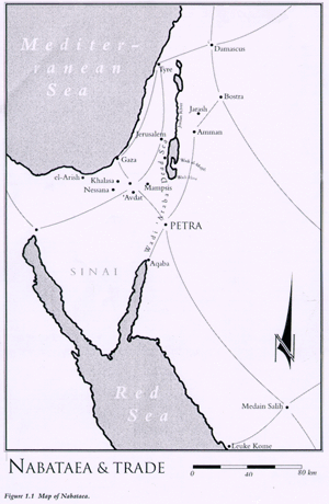
location of Petra
Click to get larger version
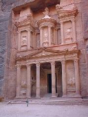
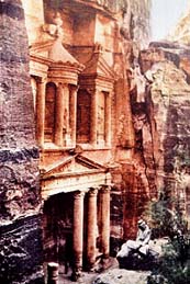
Petra (from the Latin word 'petrae', meaning 'rock') lies in a great rift valley east of Wadi 'Araba in Jordan about 80 kilometers south of the Dead Sea. It came into prominence in the late first century BCE (BC) through the success of the spice trade. The city was the principal city of ancient Nabataea and was famous above all for two things: its trade and its hydraulic engineering systems. It was locally autonomous until the reign of Trajan, but it flourished under Roman rule. The town grew up around its Colonnaded Street in the first century CE (AD) and by the mid-first century had witnessed rapid urbanization. Following the flow of the Wadi Musa, the city-center was laid out on either sides of the Colonnaded Street on an elongated plan between the theater in the east and the Qasr al-Bint in the west. The quarries were probably opened in this period, and there followed virtually continuous building through the first and second centuries CE.

The Treasury
According to tradition, in ca. 1200 BCE, the Petra area (but not necessarily the site itself) was populated by Edomites and the area was known as Edom ("red"). Before the Israelite incursions, the Edomites controlled the trade routes from Arabia in the south to Damascus in the north. Little is known about the Edomites at Petra itself, but as a people they were known for their wisdom, their writing, their textile industry, the excellence and fineness of their ceramics, and their skilled metal working.

The next chapter of history belongs to the Persian period, and it is posited that during this time the Nabataeans migrated into Edom, forcing the Edomites to move into southern Palestine. But little is known about Petra proper until about 312 BC by which time the Nabataeans, one of many Arab tribes, occupied it and made it the capital of their kingdom. At this time, during the Hellenistic rule of the Seleucids, and later, the Ptolemies, the whole area flourished with increased trade and the establishment of new towns such as Philadelphia (Rabbath 'Ammon, modern Amman) and Gerasa (modern Jerash). Infighting between the Seleucids and Ptolemies allowed the Nabataeans to gain control over the caravan routes between Arabia and Syria. Although there were struggles between the Jewish Maccabeans and the Seleucid overlords, Nabataean trade continued.

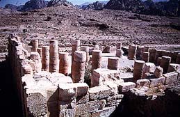
The Temple of Winged Lions
With Nabataean rule, Petra became the center for a spice trade that extended from Arabia to Aqaba and Petra, and onward either to Gaza in the northwest, or to the north through Amman to Bostra, Damascus, and finally on to Palmyra and the Syrian Desert. Nabataean Classical monuments reflect the international character of the Nabataean economy through their combination of native tradition and the classical spirit.

But among the most remarkable of all Nabataean achievements is the hydraulic engineering systems they developed including water conservation systems and the dams that were constructed to divert the rush of swollen winter waters that create flash floods.

In 64-63 BCE, the Nabataeans were conquered by the Roman general, Pompey, whose policy was to restore the cities taken by the Jews. However, he retained an independent Nabataea, although the area was taxed by the Romans and served as a buffer territory against the desert tribes. Completely subsumed by the Romans under the Emperor Trajan in 106 CE, Petra and Nabataea then became part of the Roman province known as Arabia Petraea with its capital at Petra. In 131 CE Hadrian, the Roman emperor, visited the site and named it after himself, Hadriane Petra. The city continued to flourish during the Roman period, with a Triumphal Arch spanning the Siq, and tomb structures either carved out of the living rock or built free-standing. Under Roman rule, Roman Classical monuments abounded — many with Nabataean overtones.

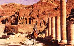
The Colonnaded Street
By 313 CE (AD), Christianity had become a state-recognized religion. In 330 CE, the Emperor Constantine established the Eastern Roman Empire with its capital at Constantinople. Although the 363 earthquake destroyed half of the city, it appears that Petra retained its urban vitality into late antiquity, when it was the seat of a Byzantine bishopric. The newly excavated Petra church with its papyrus scrolls document this period, especially in the sixth century, a phenomenon less well-attested in other sites so far south of 'Amman. In this period there is also striking archaeological and documentary evidence for accommodation between Christians and the pagan aristocracy. Thereafter one can read the archaeology of a fragmented middle Byzantine community living among and re-using the abandoned limestone and sandstone elements of its classical past. The inhabitants during the Byzantine Period recycled many standing structures and rock-cut monuments, while also constructing their own buildings, including churches — such as the recently excavated Petra Church with the extraordinary mosaics. Among the rock-cut monuments they reused is the great tomb or the Ad-Dayr (known also as 'The Monastery'), which was modified into a church. With a change in trade routes, Petra's commercial decline was inevitable. An even more devastating earthquake had a severe impact on the city in 551 CE, and all but brought the city to ruin. With the rise of Islam, Petra became a backwater community. Petra was revealed to the western world in 1812 for the first time since the Crusades when it was re-discovered by the Swiss explorer Johann Ludwig Burckhardt.

Past Excavations

As one of the most spectacular sites in the Middle East, Petra has long attracted travelers and explorers. During the 19th century, the site was visited and documented by several Europeans, after J. L. Burckhardt’s initial visit. A synthesis of the site was published by Libbey and Hoskins in 1905, presenting one of the first overviews in print. Archaeological excavations began in earnest at the turn of the century, with the earliest scientific expedition being published in Arabia Petraea in 1907, by A. Musil. In the 1920's R. E. Brünnow and A. von Domaszewski surveyed the site and published an ambitious mapping project in their Die Provincia Arabia. This survey has since undergone many necessary revisions, the most recent of which was published by Judith McKenzie in 1990.

An early photograph of
the Treasury
Modern excavations continue to increase our understanding of the site and correct the work of earlier scholars. In 1958, P. J. Parr and C. M. Bennett of the British School of Archaeology began an excavation of the city center which remains the most informative and scientific to date. Recently, the Petra/Jerash Project, undertaken by the Jordanian Department of Antiquities, the University of Jordan, the University of Utah, and Swiss archaeologists, have excavated a number of monuments at these two sites. Architectural remains now visible at Petra indicate a thriving city, however, despite almost 100 years of excavation, only one-percent of the city been investigated.

The Great Temple was first explored by Brünnow and von Domaszewski, but it was Bachmann, in his revision of the Petra city plan, who postulated the existence of a “Great Temple,” aligned with the Colonnade Street, lying on the hillside to the south. He speculated that the temple was approached through a monumental Propylaeum with a grand staircase leading into a colonnaded, terraced Lower Temenos, or sacred precinct. Another broad monumental stairway led to a second, Upper Temenos. At its center was the temple, with yet another flight of stairs leading into the temple proper. While no standing structures were revealed before these excavations, the site is littered with architectural fragments, including column drums, probably toppled by one of the earthquakes which rocked the site. Given the promise of the Great Temple precinct and its importance in understanding Petra’s architectural and intercultural history, it is remarkable that it remained unexcavated until 1993 when the Brown University investigations began.

 
  arc     arc  
arc     arc

Copyright© 1999 Brown University