

Martha Sharp Joukowsky
Petra Great Temple Excavations
Institute for Archaeology and the Ancient World
Brown University, P. O. Box 1837
Providence RI 02912 USA
[email protected]
The Luther I. Replogle Foundation, the Brown University Exploration Fund, the Joukowsky Family Foundation, and several private donors support archaeological research at the Petra Great Temple. The 13th excavation season by Brown University archaeologists took place from June 11 until August 4, 2005. To better understand its stratigraphy and phasing, excavations continued in all sectors of the Great Temple—Propylaeum, Lower Temenos, Upper Temenos and the Great Temple proper.
This campaign would not have been possible without the generous assistance of the Jordanian Department of Antiquities, Fawwaz al-Kraysheh, Director, and Suleiman Farajat, Director of the Petra National Park and the Department of Antiquities Representative. We are also grateful to Department of Antiquities Representative, Samia Fallahat, and the American Center of Oriental Research, Pierre M. Bikai, Director. We would also like to express our thanks to Brown University for making this season possible.
Brown University archaeologists included Martha Sharp Joukowsky, Director, Artemis W. Joukowsky, photographer,[1] and five supervisors served as most valued staff members, including Emma Susan Libonati, Marshall Agnew and Eleanor A. Power, (Surveyors), Tarek M. Khanachet, and Christopher A. Tuttle. Deirdre G. Barrett expertly processed the finds as our Registrar-Cataloguer and lamp analyst, and Christian Augé analyzed our coins. We were supported by a work force of 50 devoted Bedouin, directed by Dakhilallah Qublan, Foreman. Rune Frederiksen spent two weeks at the site as our Theater Consultant. Our discussions revolved around the study and future publication of the Petra Great Temple Theater.
The Petra Great Temple occupies the site on a south slope south of the Roman Road just east of the Temenos Gate of the Qasr al-Bint. Founded in the last quarter of the first century BCE, the Great Temple is the result of a great urbanization program undertaken by the Nabataeans. Located in the heart of the city, the Great Temple is one of the monumental complexes of Petra, and because it houses a theater in its center, it appears to celebrate civic as well as a religious functions. As seen today, the temple is a freestanding tetrastyle in antis building in an elevated Upper Temenos.[2]
Fieldwork 2005
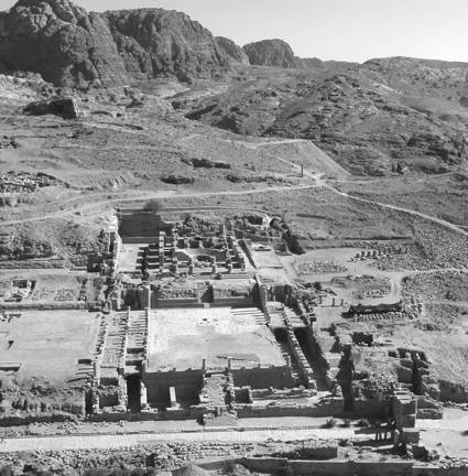
Fig. 1. Aerial view of the Petra Great Temple to south at the completion of the 2005 excavations.
The 2005 site plan is presented in Fig. 1. Fig. 2 illustrates the four divisions of the precinct: the Propylaeum, the Lower Temenos, the Upper Temenos and the Great Temple proper.
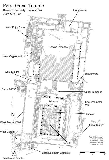
Fig. 2. Plan of the Petra Great Temple precinct with areas identified (Paul C. Zimmerman, Brian A. Brown, Christian F. Cloke, Marshall C. Agnew, and Eleanor A. Power).
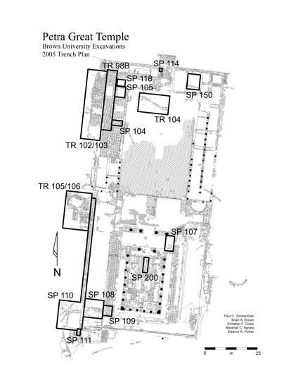
Fig. 3. Petra Great Temple Site Plan showing the positions of the 2005 Trenches and Special Projects (Paul C. Zimmerman, Brian A. Brown, Christian F. Cloke, Marshall C. Agnew, and Eleanor A. Power).
The site plan outlined with 2005 projects is illustrated in Fig. 3. Four large trenches and eleven Special Projects are excavated to demystify stratigraphic problems. The phasing and dating of the site [3] will be employed in our discussion of each 2005 trench or Special Project’s development. This 2005 report summarizes the excavations and phasing, the artifact repertoire, and concludes with the consolidation and restoration measures undertaken.
Propylaeum
The 2005 campaign had three important trenches in the Propylaeum East, Center, and West. Activities in the Propylaeum and the Lower Temenos are illustrated in Fig. 4.

Fig. 4. Great Temple to south with 2005 excavation activity in the Propylaeum and Lower Temenos.
Propylaeum East
In 2005 the excavation of Special Project 150, a 2.30-by-2.30 m sondage, reveals an assemblage of architectural features at a shallow depth below the floor level in East Propylaeum Room 2. Supervised by Christopher A. Tuttle the complexity of these features is not completely understood. The earliest stage encompasses the early wall constructions found in the sounding, although it is not at all certain that these architectural features are contemporary, or even interrelated.
Propylaeum Central Stairs
In 2005, a small probe 1.20-by-1.20 m, supervised by Tarek M. Khanachet at the bottom of the earlier stairs adjacent to the Room 1 landing in Special Project 114 confirms that at the entry to Room 1, the ballista ball assemblage is not found under the stairs, so the ballista balls used as rubble fill and leveling for the flooring of the Propylaeum West do not continue under the landing pavers for the earlier steps, leading us to conclude that the ballista balls predate both staircases.
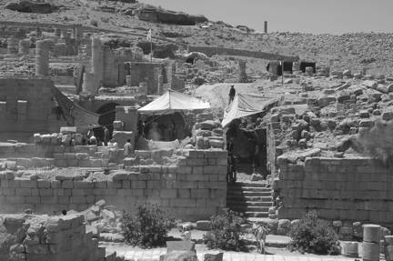
Fig. 5. Lower Temenos West Cryptoporticus east gallery, completed excavation to north.
Thus, two possibilities emerge: if the current date for the ballista balls is correct (Site Phase VII, CE mid-second century), then both the early and later stairs are from the Roman period; alternatively, the ballista balls could be earlier and the early steps are from the Nabataean period. A careful analysis will shed more light on the dating of this area.
West Propylaeum South Gallery
In 2005 Special Project 118 is undertaken by Christopher A. Tuttle to clarify the nature of the access into the West Cryptoporticus East from the south gallery of the Propylaeum West—this was not evident from earlier excavations.[4] The awkward height difference between the south gallery floor level and the cryptoporticus would have been well served in antiquity by stairs. This 2.35-by-3.00 m sondage succeeds in clarifying the nature of this access, indicating that stairs are non-existent at the time of the destruction event(s), suggesting that the West Cryptoporticus East ceases to function before the collapse occurs.
Lower Temenos
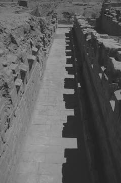
Fig. 5. Lower Temenos West Cryptoporticus east gallery, completed excavation to north.
West Cryptoporticus
Trench 98B uncovers the west gallery of the West Cryptoporticus, as can be seen in Fig. 5. Excavated by Tarek M. Khanachet, Trench 98B, measuring 17.21 m-by-3.93 m, completes the excavations to the west gallery paved floor. Martial artifacts continue to be recovered. Fig. 6 is a collection of arrowheads and Fig. 7 is a cheek piece from a helmet.
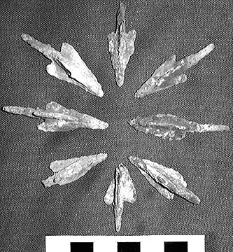
Fig. 6. Arrowheads from the West Cryptoporticus
excavations.
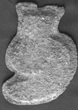
Fig. 7. Cheek piece from the West Cryptoporticus excavations.
During the 2005 season we wrestled with an important question: What lay below the pavement of the West Cryptoporticus galleries? In 2005 we decide to remove a section of flagstone pavement and excavate a 4.00-by-4.30 m sondage below the east gallery floor. Supervised by Christopher A. Tuttle and known as Special Project 104, 13 stages in the stratigraphy are identified, beginning with a Pre-Site Construction Phase I from the earliest pottery assemblage to range between 125 BCE and 50 BCE. The stratigraphy reveals a complex sequence of natural and human events. Beneath the Lower Temenos is at least one earlier period of architectural development and the course of the Wadi Musa likely is to have flowed further to the south prior to the construction of the artificial terracing for the precinct. The presence of two early activity strata also raises the intriguing possibility of tent habitations in the area dating from the elusive period of Nabataean history before permanent architecture is constructed. Bedrock is not reached. The Cryptoporticus galleries are constructed over earlier remains, however the pavement is laid after 50 BCE. But how long after? That poses an interesting question.
To better understand the stratigraphy of the West Cryptoporticus east gallery, Special Project 105 is also excavated in 2005; a 1.50 m-by-4.30 m probe, supervised by Christopher A. Tuttle, is placed in the east gallery of the West Cryptoporticus. Here terracing underlies the preparatory construction for the gallery, and there are four stages in the construction sequence of the West Cryptoporticus East—under terracing, preparatory constructions, wall constructions, and floor leveling. Concentrating on the phasing of the area, the excavations disclose the area’s later uses and ultimate collapse. The lowest layer is associated with Pre-Site Phase I and Site Phases I and II are from the Special Project 104 sounding, supra, with its various strata; sedimentation, habitation, and pre-construction preparation. Above this is Site Phase IV Grand Design when the West Cryptoporticus is constructed with the insertion of vaults. In Site Phase V, the vaults are blocked when the floors of the Cryptoportici are laid, and repairs take place in the center cryptoporticus wall that supports the vaults extending to the east and west.
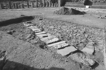
Fig. 8. Lower Temenos Trench 104 canalization capstones to southeast in situ.
Tarek M. Khanachet excavates Trench 104, an 8.00 m-by-10.00 m trench. Expecting to find a cistern-like feature revealed by the 1995 Ground Penetrating Radar, we found a mysterious extension of the canalization system, which does not appear to be functional. Pictured in Fig. 8, it may serve as an overflow for the central subterranean system.
West Entry Steps[5]
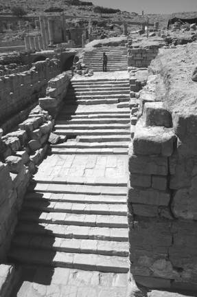
Fig. 9. 2005 West Entry Stairway to south.
Located at the extreme west of the Lower Temenos in the 2005 excavations of Trenches 102-103, this grand stairway, pictured in Fig. 9, is a continuation of the West Entry Stairs excavated in Trench 88, 2002. Inspired by that earlier recovery made it obvious that this stairway might continue up to the Upper Temenos. To bring this concept to reality, the 2005 excavations, including the removal of mountains of rubble, enable us to interrogate the data. The final dimensions of the 2005 trenches are 30.75 m north south-by-4.00 to 4.55 m in width. Now that we have completed the West Entry Stairway, the following discussion includes details of the entire feature.
This West Entry Stairway follows the slope of the Great Temple precinct that falls away at a dramatic angle from the Lower Temenos to the Roman Street. Composed of five stair flights it is interrupted by four platform landings set at irregular intervals creating an entry passage totaling 40.85 m in north south length. It is probable that more steps exist at the top of the stairway, but from the stratigraphy there is scant evidence for them. It is a comfortable south to north descent from the Great Temple to the West Baths[6] or from either of those features to the Roman Street. [7] Collapse covers all the features including the tops of most of the walls. The result of destruction and collapse, the soil is a dusky red 2.5YR ¾ Munsell color, composed of a sandy sedimentation with small stones on the surface bleeding into a more homogeneous soil with some inclusions including roof tiles, mortar either in clumps or facing from walls, and collapsed large ashlars. Few carved decorative elements are present. Intermittent episodes of burned debris probably from wooden support beams are also found above a layer of sterile sandy soil that covers most of the stairway architecture. Had it not been for this cushion of sand, greater attrition of the step architecture would be present.
In the north, the west wall is thirteen courses in height, and constructed with well-dressed sandstone ashlars, many are also slumped out of position. On a platform to the west, there is as yet an unexplored doorway leading to the West Baths that undergoes modifications—the lower courses of this wall’s east face exhibit ancient repairs.
From the evidence we cannot assume the stairway is unroofed. The distance between the east and west walls is between four to five meters, which is a reasonable span for wooden beams to support roof tiles, and fragments of covertile and pantiles were found in the collapsed debris, so we assume it is roofed.
The well-preserved stairs are characterized by large impressive well-dressed ashlars set into mortar built from the bottom to the top. These exceptional steps are expertly laid and in many cases are bonded to the east and west walls with plaster; they are constructed as a single unit to abut the sidewalls. Although each flight of steps and platforms differs in dimensions, the platforms stabilize the steps by providing a secure foundation between flights. The platforms are composed of well-laid plain white limestone flagstones with tightly fitted blocks affixed with mortar. In view of the preservation of these features, it is worth noting that ancient Nabataean stonemasons had a developed, exceptional technology in their design.
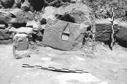
Fig. 10. 2005 West Stairway to west with the nefesh and betyl in situ.
Underlying debris collapse and fill off to the west between the two uppermost stair flights is a terraced platform landing measuring 4.97 m north south-by-4.35 m east west. The platform elevation averages 896.500 m, and it is bordered to its east with smoothed blocks measuring 0.25 m to 0.32 m in size. Behind this platform to the west is a narrow corridor leading to the West Baths. Resting on this platform, just below the corridor doorway, pictured in Fig. 10 is found a nefesh[9] accompanied by a betyl, positioned behind an ash-discolored deposit. This nefesh is a white limestone/sandstone slab with an incised obelisk carved above a squared cut betyl block, which is removable.[10] The block itself measures 0.78 m in height-by-0.57 m in width. The carved obelisk is 0.19 m in height-by-0.135 m in width and the small nefesh betyl measures 0.135 m wide-by-0.13 m in height. Besides the nefesh and the betyl are prolific collapsed ashlars numbering in the 900s. Little pottery, some bone, glass, and metal are found, but of note are a bronze lance head and four coins. Since this area has been subject to erosion over the millennia, the artifact repertoire does not originate from sealed deposits, so little dating can be ascribed to the artifact record.
Now there is an important west access to the Petra Great Temple—an access, contemporary with its Grand Design in Site Phase IV. The date of its final use we ascribe to Site Phases XII-XIII or to post-date the 512 CE earthquake, after which the West Entry is covered with a massive collapse fill, suggesting the West Entry Stairs are in use for approximately 500 years. We speculate the upper stairs are destroyed by natural causes; nonetheless it is clear that connecting walls provide a link between the West Stairway and the West Baths.
The Petra Great Temple has regained a remarkable and yet puzzling monumental stairway, which is clearly a product of desired access, providing a direct approach to the Great Temple Upper Temenos from the Roman Road, while bypassing the Lower Temenos. Integral to the precinct, it exists independently and/or interdependently with the Great Temple and the West Baths. This stairway is one of the most impressive flights of stairs so far found associated with freestanding buildings in Petra. Indeed, it gives us a fascinating insight into the Nabataean understanding of structural engineering. In addition to the architectural remains is the in situ discovery of the nefesh stele and the accompanying betyl, which certainly is one of the most spectacular finds of the Great Temple excavations. This roughly carved, freestanding bas-relief placed on The West Stairway raises several questions. What was the compelling rationale for this memorial monument’s placement? On stylistic and iconographic grounds, why does our nefesh contain both the betyl and an obelisk with a separate freestanding rectilinear betyl placed next to it? Robert Wenning, in his 2001 article, “The Betyls of Petra,” In BASOR 324: 79-95, states that the nefesh is commonly found along the “paths of the city.” This suggests that the placement our West Stairway is an important city artery.[1] Obviously, the monuments on this platform are significant religious commemorative installations, indicating that some ritual is performed here—some Nabataean 2000 years ago expressed a dedicatory tribute both to the god and probably to a person of considerable influence.
Upper Temenos
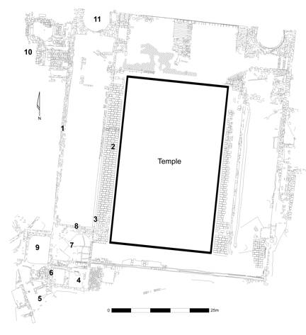
Fig. 11. Upper Temenos plan with major features numbered: 1. West Precinct Wall, 2. West Walkway, 3. West Walkway Wall, 4. Baroque Room Complex, 5. Residential Quarter, 6. Residential Quarter Steps, 7.West Plaza Bedrock, 8. East West Support Wall, 9. Cistern-Reservoir, 10. Roman Baths, and 11. West Exedra (Marshall C. Agnew, Eleanor A. Power).
The plan of the Upper Temenos is shown in Fig. 11 with major features numbered. The 2005 excavations continue between the Great Temple West Walkway Wall and the West Precinct Wall, and from the West Precinct Wall further to the west. The West Precinct Wall divides the two areas. Each unit is discussed separately beginning with the previously unexcavated strip 40.00 m north south-by-11.00-12.00 m east west between the West Walkway and West Precinct Walls. This includes the West Precinct Wall, the Residential Quarter Steps, the West Plaza Bedrock Installations and the East West Support Wall. The discussion of these features follows.
West Precinct Wall
Located in the west temple precinct is the West Precinct Wall. The length of the West Precinct Wall is cleared in trench Special Project 110 in 2005, supervised by Eleanor A. Power and Marshall A. Agnew. Extending 62.00 m in north south length, we predict its original depth at 899.747 elevation, or to be approximately 3.28 m in preserved height. As yet this badly eroded wall’s excavation is not completed.
Inside the West Precinct Wall are the Residential Quarter Steps linking the Residential Quarter to the Settling Tank of the Baroque Room complex. Special Project 111 involves the removal of the steps to test the stratigraphy. Supervised by Tarek M. Khanachet, it is concluded the Residential Quarter steps are built on layers of rubble and soil fill with layers of wadi mud directly beneath. Pottery is also recovered that confirms their construction to Site Phase IV.
West Plaza Bedrock Installations
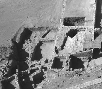
Fig. 12. Aerial view of the West Plaza.
East West Support Wall
During the excavations of Special Project 108 it becomes clear that the West Plaza architecture is much more extensive than we expect. Set on bedrock, the East West Support Wall opens at a 904.849 m elevation and closes at an elevation of 901.549 m; it is 12.00 m in length-by-2.00 m in width, and 5.10 m in height.
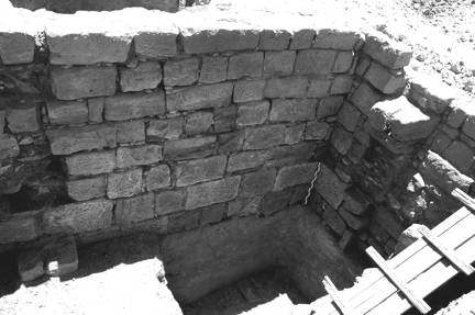
Fig. 13. View of the East West Support Wall abutting the West Precinct Wall to southwest.
Illustrated in Fig. 13, this wall is composed of five to eight ashlar courses, with the lowest two courses potentially from an earlier building phase. The East West Support Wall, which in itself is a monumental construction, is designed and constructed with the express purpose of providing an artificial platform for the temple. From the exposure of the juncture between the West Precinct Wall and the East West Support Wall, it is clear that both walls are originally constructed in Site Phase I and therefore are intrinsically linked.
Its discovery clarifies the west support for the temple. Hitherto we were uncertain as to how the temple architecture is supported on the west, assuming that where the bedrock falls away, fill is brought in to build up the founding level. Once the temple architects choose the specific location and plan, they manipulate the landscape to bring their architectural concept to fruition. In creating this massive wall, they support the structure by using enormous stones and supportive retaining walls for the substructure.
The Cistern-Reservoir[11]
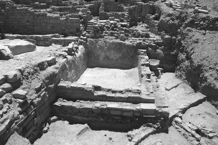
Fig. 14. Cistern-Reservoir to south with the Residential Quarter behind.
In 2005 the West Precinct Wall is further examined in the south of Special Project 110. This project, supervised by this author aided by Elizabeth A. Smolenski, involves the discovery and excavation of a Cistern-Reservoir (Fig. 14) extending to the west just below the Residential Quarter. Trench measurements average 11.85 m north south-by-9.20 m east west. On the north the trench is bordered by unexcavated fill, on the south it abuts bedrock and the excavated Residential Quarter, to the east it rests against the southernmost extension of the West Precinct Wall and bedrock, and on the west it abuts an unexcavated fill deposit. This monumental cistern-reservoir measures 38.8 square meters-by-an average of 1.96 m in depth, and holds approximately 19,571.97 gallons of water. On the north and west are walls repaired in antiquity, and resting beside the west wall is a monumental stone basin.
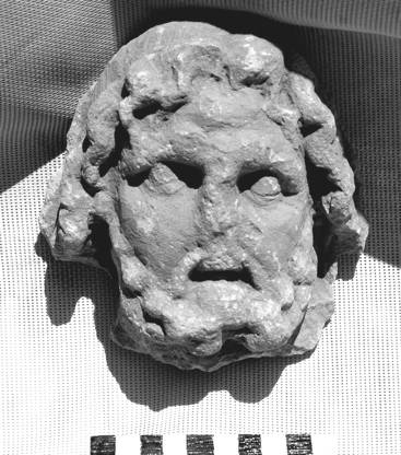
Fig. 15. Head of a deity found in the collapse of the West Precinct Wall.
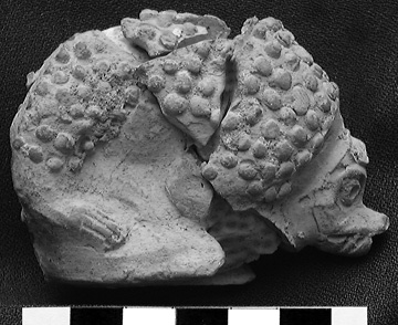
Fig. 16. Hedgehog found in the lowest deposits of the Cistern-Reservoir (Scale: 5 cm).
There are questions that may never be answered. How was this structure roofed? Was it a flat roof or are the ashlars seen on the west for an arched structure? In its collapse did it bring down arches that spanned from east to west? How did water enter the Cistern-Reservoir? What is its relationship to the Residential Quarter? We assume that it is in use at the same time, however access to the Residential Quarter is difficult given the cistern is there.[12]
The Roman Baths
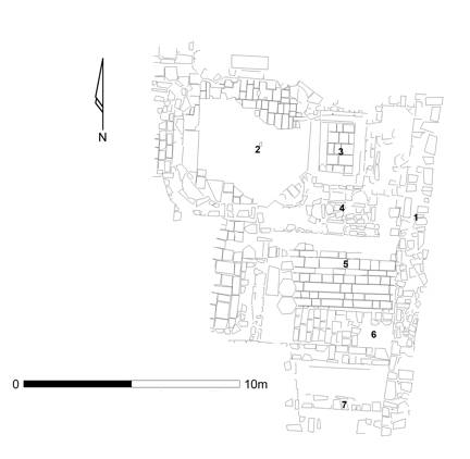
Fig.17. Plan of the Roman Baths. 1. West Perimeter Wall, 2. Vestibule, 3. Frigidarium, 4. Lavatories Bathrooms, 5.“Hypocaust Room,” 6. Steps, and 7. East West Wall (Marshall C. Agnew and Eleanor A. Power).
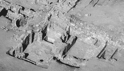
Fig. 18. Aerial overview of the Roman Bath Complex.
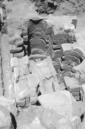
Fig. 19. ‘Well Room’ originally thought to be Lavatories-bathrooms, 2005 Roman Baths to north.
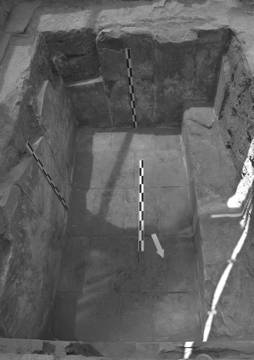
Fig. 20. 2005 Roman Baths, frigidarium to south.
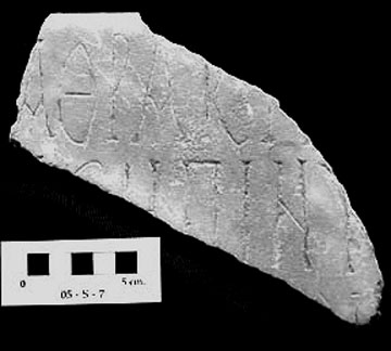
Fig. 21. Marble inscription (Cat. No. 05.S.7) from the Upper Temenos Roman Bath. Length 19.45 cm, W. 9.14 cm, Th. 2.56 cm.
Of primary importance is establishing a chronology for the construction and destruction events that shape the bath remains. The earliest event is the construction of the West Precinct Wall, which is part of the site preparation in Phase I (first century BCE). This massive wall defines the extent of the temple. The next stage of construction is an east-west wall in the south of the trench (numbered 7 on the Fig. 17 plan). This wall, which clearly abuts the West Precinct Wall, is large and well built, and extends across the bath perimeter, continuing further to the west. It is unclear why it is constructed, but it seems to belong with Site Phase IV of the Great Temple phasing, as part of the Nabataean Site Phase IV Grand Design. This suggests that the scope of the Grand Design extends beyond the confines of the West Precinct Wall and possibly connects it with other structures and as yet unexcavated complexes further to the west.
With the annexation of Nabataea by the Romans in CE 106 new architectural concepts and social norms arrive in Petra, poignantly demonstrated by the construction of the bath complex. This is a grand undertaking, the extent of which is still not fully revealed. In comparison with Nabataean masonry the workmanship is generally mediocre—further support for the Byzantine date for the finds above the floor.
Following the construction of the bath complex, there is a stage of reconfiguration occurring during Phase VII (CE mid second century). Abutting the West Precinct Wall, stairs in the “hypocaust room” are added, using robbed-out column drums and ashlars; the pavers of the “hypocaust room” floor extend underneath the stairs. This raises a question of a redirected access into the bath complex—with the addition of the stairs, traffic flow changes, potentially suggesting a change in use of the space. Site Phase VIII is a relatively short period of sedimentation seen just above the floor in the “hypocaust room.” This is the first sign of disuse of the bath complex and an abandonment of its original purpose. Following this also in Site Phase VIII, there is the purposeful dumping in the “hypocaust room.” The massive quantity of hypocaust and flue tiles suggests that this debris is from a caldarium, most likely near by. This dumping is Byzantine indicated by the extraordinary numbers of Byzantine glass and lamps.
The full collapse of the bath complex and the West Precinct Wall is part of the major CE 363 collapse (Site Phase IX) of the Petra Great Temple. This is a cataclysmic event, with much of the West Precinct Wall falling into the bath complex, and whole sections of architecture being dislodged and collapsing. Following this event, the area is fully covered by wash and overburden.[15]
With this broad chronology established, we can now look at some of the interesting questions that stem from the discoveries and interpretations of the baths. Of significance to the entire Petra Great Temple, perhaps, is the shift in our understanding of Site Phase VI. It now appears that this period, which covers the annexation of Petra by the Romans and the resulting Romanization of the site, is much more active than previously thought. More than just a period of minor collapse and repair, there appears to be more large-scale construction including the bath complex, and possibly other features. There is clearly a reuse of the Nabataean Great Temple for secular purposes, and the presence of something as public as a bath highlights this alteration. This new purpose continues the use of the Petra Great Temple as a public space, although the bath has no religious or civic purpose beyond being a gathering point for its clientele. It is interesting to question as well who the clientele are. A small bath complex, especially with the West Baths just to the northwest, would seem to have a restricted membership. Are these people a Byzantine elite? A resident family?
The excavation of Trench 105-106 is much more complex and informative than we could hope. The unearthed remains give us insight into a later period of history in Petra, and, just as importantly, show us the impact of Romanization on Nabataea. With further study and excavation, we can learn even more from this small but significant structure.
Temple
In the Great Temple three Special Projects are excavated; West Walkway Special Project 109, the East Pronaos Special Project 107, and a sondage below the orchestra floor of the Theater Special Project 200.
West Walkway Sondage
Tarek M. Khanachet excavates a West Walkway sondage, Special Project 109, measuring 3.30-by-3.63 m, in 2005. The West Walkway Wall abuts the East West Support Wall and the temple platform with rubble fill beside it. The previous excavations prove that the bedrock on which the temple is constructed slopes off steeply to the south and immediately to the west of the West Walkway. A platform is then purposefully built up with monumental ashlar and rubble fill above the bedrock, as part of the temple substructure. During the course of the excavation, a gap is noticed beneath one of the ashlars that is thought to be canalization, but is found to be a vertical shaft down into the fill created by the space left between layers of monumental ashlars when the substructure is constructed. Therefore, the West Walkway and the west portion of the temenos platform are built up by enormous rough-cut ashlars resting on bedrock; the West Walkway Wall is constructed on a dirt and soil foundation, approximately 0.40 m west of the original platform edge. The East West Support Wall (see the Upper Temenos discussion) abuts the platform construction and rubble/ashlar fill to support the monumental platform construction.
Fig. 22. Pronaos sondage to north against the Porch stylobate wall.
Temple East Pronaos
In 2005 Special Project 107, a 6.40-by-3.55 m sondage supervised by Emma S. Libonati at the east end of the East Pronaos proves that least a portion of the Pronaos and tetrastyle in antis porch are later additions to the original distyle in antis façade. The sondage, shown to the north against the stylobate and East Anta in Fig. 22, and to the south against the East Corridor and the East Distyle Anta in Fig. 23,
Fig. 23. Pronaos sondage to south against the East Corridor Wall and the Distyle Column.
two very important structures are unearthed: an early stuccoed platform/wall and an early east west canalization system. Fig. 24 shows the stuccoed platform set between the walls of the Pronaos.
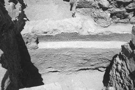
Fig. 24. Pronaos sondage, detail of dimpled platform to east.
A vertical water system located directly below the distyle in antis foundation wall may be part of an installation built around a bedrock spring, but there is no connection between it and the East Plaza artery (and we are unsure if it flows into the Central Artery of the subterranean canalization system). It is also difficult to phase it adequately. The stuccoed platform/wall is located north of the water system at an oblique angle to the distyle in antis foundation wall, and it is difficult to determine both its function and its overall size as only one side is exposed. The ledged platform south face is covered by thick gray white stucco decorated with dimpled finger impressions. In association with this platform are Hellenistic and Early Nabataean ceramics and quantities of bone.
Theater Sondage
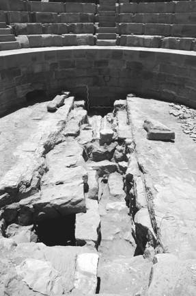
Fig. 25. Theater sondage through the orchestra floor to south.
Encouraged by Rune Frederiksen to investigate the Theater orchestra, Special Project 200 is excavated. Supervised by Emma S. Libonati, a 6.96-by-1.96 m sondage below the theater orchestra floor helps us analyze the Theater construction and in the recovery of datable material remains. Fig. 25 shows the orchestra with the sondage against the theater wall, and Fig. 26 is the sondage to the north against the Pulpitum wall.
Fig 26. Theater sondage to north of the Pulpitum wall.
The uncovering of a central pivot drum (Fig. 27), 0.38 m diameter, is presumably used for laying out the apsidal structure of the Theater; it is an unusual feature to find in situ, with both horizontal and vertical pivot points. The horizontal pivot stone is a common feature in Hellenistic theaters, suggesting architects from the Greek East are influenced more by structures from Hellenistic theater cities rather than the Roman theater cities.
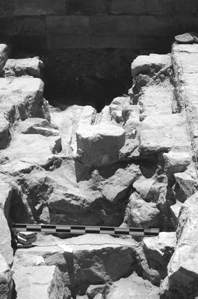
Fig. 27. Theater sondage, detail of column drum to south.
There is a possibility that when the Theater is placed in the temple that a small colonnade or decorative structure was dismantled and its parts reused as fill or as portions of buildings. In other places in the Great Temple there are reused smaller column drums with roughly the same diameter. Likewise, the reused pieces of stucco in the fill suggest that some orchestra fill originates from a period of redecoration.
Just as puzzling is the discovery of the subterranean canalization system extending below the orchestra floor. There is a discrepancy between the orchestra wall and height of the canalization central artery capstones. In comparison with the East Vaulted Chamber where the top of the capstones was at 905.341 m, and in the orchestra itself the north the top level of the capstones is 905.146 m, but the orchestra floor is at 905.526 m suggesting a build up and leveling during the construction of the theater area.
Study of the canalization system under the theater structure, the stage, and the Pronaos (between the two previous sondage explorations)[18] shows that the central canalization artery accumulated a tremendous amount of sediment, requiring repairs for flushing it out in antiquity. The reexamination of the Central Arch portion of the subterranean canalization system in Special Project 120, 2004 proves that there is no south inlet for the central artery but that it is constructed in the earliest architectural site phase of the complex. The artery in the Theater confirms this.
With few exceptions the capstones of the central artery are cracked in the middle, whether this results from earthquake damage or is prior to the abandonment of the temple is difficult to say; but clearly the structural integrity of the system is not flawless and might bring about the abandonment and general rebuilding of the water systems in the Great Temple precinct. There are arteries from the west and east adjacent to the central staircase that are the viable water carrying systems in the first phase of canalization construction.[19]
Of particular note for the canalization construction is the progressive narrowing in the area underneath the pulpitum and the distyle in antis foundation wall. The west wall of the canalization consistently slopes westward, while the east wall narrows at roughly 2.00 m intervals and banks gently to the west. The result is a gradual narrowing of the canalization: the width at the north of the orchestra is 0.76 m while at the north prior to the blockage in the Pronaos it is 0.56 m. The most significant narrowing is at 3.80 m from the canalization opening in the Theater where the distyle in antis foundation wall intercepts the canalization. From an examination of the construction technique, the distyle in antis foundation wall is built together with the central canalization and may be a contributing factor to the westward swing of the canalization.
The canalization follows a fairly linear route slightly east of the center axis of the building itself, except in the temple Pronaos where it is directed westward before swinging eastward again to flow underneath the central staircase between the Upper and Lower Temenos—this linear route continues through the Lower Temenos. This pattern, however, is disrupted in the temple Pronaos by the westward bend, which leads to some architectural questions. Was it necessary for the builders to avoid the Pronaos center because of a pre-existing architectural feature or could this section be rebuilt when the tetrastyle in antis is added? Either an early east west water canalization with a westward jog does exist in the area of the Pronaos, or there is a lower, earlier water system in place.
Artifacts 2005
The 2005 Great Temple catalog includes 167 objects of which 78 are coins, 10 of bone, 18 of faïence, 7 of glass, 20 metal objects including arrowheads (Fig. 6), 16 objects of pottery, plus 6 lamps, and 12 stone artifacts, including the head of a deity shown in Fig. 15. Our databases of 13 years of excavation continue to swell with architectural fragments bringing the total up to 16,883. There are also considerable cultural materials, numbering 38,763 for the 2005 season bringing the overall total to 386,763 artifacts (fragments of pottery, bone, metal, glass, etc.) in our Grosso Modo database.
Consolidation and Preservation 2005-2006
Consolidation and restoration are under the direction of Dakhilallah Qublan, and include numerous projects involving the pointing of walls in all areas affected by the 2005 excavations. There is particular urgency to point the West Entry Stairway, which is in a state of collapse and requires stabilization. The Cistern-Reservoir also requires the pointing of its north and west walls.
The disturbed uppermost section of the West Stairway excavation is to be covered with clean sand and covered with a platform with a railing for support. For ease of passage, an east west bridge is constructed between the Upper Temenos and the Lower Temenos Triple Colonnade. As for the Roman Baths, many small projects are underway such as the reinsertion of the limestone curved wall elements that had tumbled out of the Roman toilets, the replacement of a lintel; the north, east and south walls are to be reconstructed to the same height as the north wall and door; the frigidarium entry is to be built to one level with white mortar and/or limestone slabs. The full exposure of the pipe around the base of the bathrooms requires mortar support, but the major project is attending to the West Precinct Wall—to move the slumped ashlars and replace them with new blocks.
In the Great Temple several projects are undertaken including the construction of a frame around the excavated Temple Theater orchestra so that the stratigraphy can be viewed, and old and new pavers are to be intermingled and set to cover the Great Temple Forecourt (leaving the subterranean canalization system open). As for the Central Stairs, three sets of stairs in limestone are to be restored—two upper steps, two middle steps, and two lower steps, leaving the stair bedding open on the remaining steps. Limestone is to be used to mark the difference from the sandstone east and west stairs that are later additions. As for the artifacts, all the metal artifacts, including the coins are in Amman to be restored by Naif Zaban at the American Center of Oriental Research, after which they will be analyzed and returned to the Petra Museum. A copy is to be made of the nefesh with one in situ on the West Stairway where the original is found; the original will be safeguarded by the Petra Museum.
At Home Research 2005
At least four months are dedicated to the drafting of measured drawings,[20] updating the records of all project areas and the Great Temple Web Page. These projects range in complexity from scanning and digitizing illustrations to updating our extensive computerized site databases. A great deal of time is spent in the preparation of The Petra Great Temple Volume II, a summary of our excavations since their inception. Vol. II is part of our planned publication series which is planned to go to press in 2006, and Volume III will be devoted to specialist studies of the excavations, including submissions by Rune Frederiksen, Joseph J. Basile who continues work on the sculpture, Sarah Whicher Kansa who continues to analyze our bone corpus, and David S. Reese who is studying our shell remains, among other researchers.
In April 2005 I was honored to lecture in Grand Rapids, Michigan for the “Experience Petra Exhibition,” and in May I lectured at the American University of Beirut Museum. In September I was most privileged to celebrate the 20th Anniversary of the Anthony McNicholl Visiting Lectureship[21] in Australia and presented a series of lectures in Sydney, Adelaide, Melbourne, Canberra and Perth.
Conclusion
The remarkable portfolio of 2005 projects at the Petra Great Temple reveals the results of entrenched archaeological questions, and our consolidation and preservation of the site. Our discoveries offer an unparalleled view into the quintessential fabric of Nabataean architectural and cultural heritage. Our 13th campaign has resulted in a vast compendium of challenges that we are excited to address in 2006. I am grateful to my team and share their enthusiasm and pride in the uniqueness of the Petra Great Temple, which we have been entrusted to excavate.
Works Cited
Ruben, Isabelle (ed.).
2003. The Petra Siq. Nabataean Hydrology Uncovered. Texts by: Ueli Bellwald, Ma'an al-Huneidi, Adnan Salihi, Daniel Keller, Rajah Naser and Dawud al-Eisawi. Amman: Petra National Trust.
Wenning, Robert
2001 “The Betyls of Petra,” In BASOR 324: 79-95.
[1] Large-scale annual excavations carried out by Brown University archaeologists since 1993 have exposed the architecture of the Great Temple, and our research has concentrated on recording the site plan, and the conservation of the site, (see Joukowsky annual reports in ADAJ). For a complete bibliography please refer to our web page <http://www.brown.edu/>
[2] All photographs are to be credited to Artemis W. Joukowsky.
[4] The Small Temple’s internal measurements are 14.62-by-14.62 m; the total internal area is 213.744 m2, but the Small Temple with its Portico, measures a total of 338 m2.
[5] These excavations have been published by Sara Karz Reid (2006).
[6] Key for the Roman Byzantine Bath Complex shown in Fig. 12 (the internal dimensions for specific rooms are given). A. Platform 5.45 m north south-by-14 25 m east west, B. vestibule 2.92 m north south-by-2.08 m east west, C. caldarium 5.22 m NW wall-5.00 m NE wall-by-11.70 north wall-by-11.45 m south wall, D. splash bath (loutron) 1.40 m north south-by-1.20 m east west, E. vestibule 4.06 m north south-by-2.15 m east west, F. praefurnium 3.76-3.23 m north south-by-7.50 m east west, G. Service Passage 13.20 m north south-by-1.30 m/1.80 m east west, H. vestibule 1.98 m north south-by-1.20 m east west, I. caldarium 1.55 m/2.20 m north south-by-4.20 m east west, J. tepidarium diameter 4.20 m, K. Service Passage 0.84 m-by-2.74 m-2.80 m east west, L. Ornamental Pool 3.20 m north south-by-5.08 m east west, M. vestibule 5.70 m north south-by-5.80 m east west, N. frigidarium 2.25 m north south-by-1.47 m east west , O. settling tank 0.80 m north south-by-1.50 m east west, P. small cistern 1.75 m north south-by-1.75 m east west, Q. bathroom (toilet) 1.60 m north south-by-1.60 m east west, R. anteroom 2.48 m north south-by-2.98 m east west, S. apodyterium (bench room) 5.54 m north south-by-3.25 m east west, T. well 1.10 m north south-by-1.50 m east west, U. colonnaded corridor 3.05 m north south-by-~13.70 m, and V. court 5.90 m north south-by-4.90 east west. (Specific dimensions for features can be found in the trench reports, which are on the World Wide Web at <http://www.opencontext.org>.)
[7] The limestone platform has two adjoining rooms to its east. The room next to the platform may have served as an entry, whereas the room further to the east had broken marble opus sectile fragments, which we elected to back fill and temporarily leave for further exploration. Clearly the opus sectile was part of a hanging floor, the suspensure caldarium, for another caldarium or part of a caldarium.
[9] Architecturally these are rectangular caldaria that are divided into bays by piers, indicating they are covered by barrel vaults. The construction technique for these rooms is the same in both caldaria—ashlar masonry mixed in and covered in fire-resistant concrete and mortar rubble mixed with potsherds for the lower work levels, and elegantly appointed upper levels with white veined marble revetments on the walls and opus sectile floors. All the walls seem to abut and many are superficially bonded with an added coat of mortar. The walls often incorporate reused ashlars and broken tile fragments and they are faced with ashlars on both sides and bonded together by a wet-laid rubble core. Unfortunately it is difficult to separate the repairs and alterations that took place when many of the doors and vaults were blocked-off and there was rebuilding of floors. Only the substructure plan survives with the exception of a few rooms, such as the loutron, the tepidarium and the vestibules.
[10] The most interesting is the limestone capital discovered in the tepidarium, richly decorated with acanthus leaves in low relief above the astragal. It appears as if it was reused having been cut across the top. The diameter of this capital is 0.53 m, its height is 0.25 m and the Lewis square hole in its upper surface is 0.06 m. It appears to be a CE fourth-fifth century type, but its design has yet to find a parallel. Sandstone drum fragments are also found— some with diameters of 0.034 m and others measuring 0.43 m-to-0.47 m. Three extraordinary lintels are also part of the repertoire: one from S Rooms Chamber 5 (Seq. No. 127048) of limestone measuring 1.32 m in width-by-0.53 m in height-by-0.28 m in thickness; another (Seq. No. 127017) in limestone measuring 1.68 m in width-by-0.60 m in height-by-0.28-to-0.40 m in thickness. The third lintel is of sandstone and is much smaller than the other two. It, (Seq. No. 127024), measures 0.60 m in width-by-0.26 m in height-by-0.19 m in thickness. Many undecorated cornice fragments also came to light.
[11] The vestibule frigidarium was excavated in 2005, also by Eleanor A. Power.
[12] In the Colonnaded Corridor was a blocked vaulted channel where the complete Roman inscription (Seq. No. 120A050) was recovered.
[13] Informal email communication, November 2, 2006.
[15] It is not clear if this feature is in fact a natatio, but the supposition should not be ruled out. See the 2005 Trench 110 trench report on the web, in Open Context.
[16] The area to the south of the wall has not been excavated, but clearly the bath precinct architecture continues further south, because there are two doors in this south wall of the Colonnaded Corridor as well as steps leading over the wall and to the cistern-reservoir, hypothetical ’natatio.’
[17] We have elected to put our databases in Open Context, http://www.opencontext.org I elected to use Open Context to publish the enormous compendium of materials we had collected over the years. All of the trench and special project reports as well as our phasing charts now are available on Open Context. Open Context is an open access publication system that has enabled our Great Temple researchers to publish on line their primary field data like trench reports and databases, and media such as photographs, site plans, stratigraphic drawings and our Great Temple videos on the World Wide Web (http://www.opencontext.org). It provides an easy to use, yet powerful, framework for exploring, searching, and analyzing excavation results, survey data, and the artifacts deposited in the Petra Museum collections, because all the content is linked together as an integrated and cohesive resource and is freely available.
[18] Noteworthy architectural fragments include the capital from the tepidarium (Seq. No. 127146) 0.53 m in diameter and 0.25 in height, and the head of a deity (Helios?) in a medallion (Seq. No. 120488, length 0.145, width 0.22, thickness 0.055) from the columned corridor, and decorated fragments (Seq. Nos. 120356 and 120521) incised with wave patterns and painted also found there.
[19] Another undertaking in 2006 was the examination of each of the 6000 smaller architectural fragments stored in the East Triple Colonnade Cryptoporticus Lapidary. This seven-day process was directed by Sureya Köprülü to assist our theater expert Rune Frederiksen in his examination of the excavated theater fragments. Each fragment was examined for number/trench designation and sorted, placed in an appropriate pile, and those with the designations of the theater trenches were separated from the others; and a list was drawn up in excel. The lapidary was first refilled with fragments without theater trench numbers, and a white plastic mesh was placed over that corpus, and on top of a division of white mesh the theater fragments were placed.
[20] This head vase compares nicely with Cat. No. 94-G-4 (Joukowsky 1998:334, Fig. 6.129, Seq. No. 5114) found in the 1994 West Exedra Trench 5 Locus 37 excavations.
[21] We elected not to refill the theater sondage, but to create a means by which a theater scholar could remove the seats to view the Trench 123 sondage.