Course Design
The course is divided into three modules where each module focuses on specific materials and tasks.
Module 1: Geophysical Survey and Mapping Principles
The first module uses class room study and hands-on training with different geophysical survey methods to provide a basic introduction to the technicalities of geophysical surveys.
• basic geophysical principles and survey strategies
• application of these principles to hands-on data collection and processing
• integration of different data types into a project GIS
Module 2: Applications of Geophysical Surveys in Archaeology
The basic principles of geophysical survey methods covered in the first module will provide a foundation for the study of:
• the history and development of geophysical surveying in archaeology
• specific applications at different archaeological sites
• the official ‘place’ of geophysical surveys in archaeology, looking at government agencies and archaeological practice around the world
Module 3: Archaeological site survey
In the final module, students will work on a project implementing the theory, practice, and application histories that they have learned in the first two modules. This will be executed as a comprehensive geophysical survey project at a local archaeological site and will include:
• development of survey strategies
• implementation of geophysical surveys and data collection
• data processing and interpretation
• data integration in a GIS project and final interpretations
• presentation and reporting of the survey project results to the Joukowsky Institute and archaeological site personnel.
Comprehensive readings lists can be found on the Resources page.
Module 1: Geophysical Survey and Mapping Principles
Tuesday, September 7
Course Overview and Introduction to Archaeological Geophysics
The history of geophysical applications and its development in archaeology will be presented. Different examples will be highlighted and the current role, or 'place' of geophysical surveys in archaeology will be discussed.
Tuesday, September 14
Introduction to Archaeological Geophysics
The history of geophysical applications and its development in archaeology will be presented. Different examples will be highlighted and the current role, or ‘place’ of geophysical surveys in archaeology will be discussed.
GAFFNEY, C. & J. GATER. 1993. Chapter 1 in Development of Remote Sensing. Part 2. Practice and method in the application of geophysical techniques in archaeology, in J. Hunter & I. Ralston (eds.). Archaeological Resource Management the UK. Stroud: Sutton Publishing Ltd.
CLARK, A. 1996. Chapter 1 of Seeing Beneath the Soil, Revised Edition. London: B. T. Batsford Ltd. (available as an e-book through Josiah)
JOHNSON, J. (ed.) 2006. Chapter 1 of Remote Sensing in Archaeology: An Explicitly North American Perspective. University of Alabama Press. (available on GoogleBooks)
new
GAFFNEY, C.F., J. GATER, P. LINFORD, V.L. GAFFNEY AND R. WHITE. 2000. Large-Scale Systematic Fluxgate Gradiometry at the Roman City of Wroxeter. Archaeological Prospection 7: 81-99.
KVAMME, KENNETH L. 2003. Multidimensional Prospecting in North American Great Plains Village Sites. Archaeological Prospection 10: 131-142.
 Lab 1: Survey equipment and meter ropes.
Tuesday, September 21
Resistance Survey Principles
The following will be introduced:
• Survey principles
• Equipment
• Data collection methods
• Data processing, interpretation & visualization
Resistance Survey Reading List
Lab 2: Resistance data collection
Tuesday, September 28
Magnetometry Survey Principles
The following will be introduced:
• Survey principles
• Equipment
• Data collection methods
• Data processing, interpretation & visualization
Magnetometry Survey Reading List
Lab 3: Magnetometry data collection
Tuesday, October 5
Ground Penetrating Radar Survey Principles
The following will be introduced:
• Survey principles
• Equipment
• Data collection methods
• Data processing, interpretation & visualization
Lab 4: GPR data collection
Module 2: Comprehensive Archaeological Site Geophysical Survey
Tuesday, October 12
Site Recce
The class will visit the archaeological site where we will be doing its surveys. We will discuss the archaeology and how best to approach non-invasive mapping.
DAVID, A. 1995. Geophysical survey in archaeological field evaluation, Research and Professional Services Guideline No. 1. London: English Heritage.
GAFFNEY, C., J. GATER & S. OVENDEN. 1991. The use of Geophysical Techniques in Archaeological Evaluations. IFA Technical Paper No. 9.
GAFFNEY, C. & J. GATER. 1993. Development of Remote Sensing. Part 2. Practice and method in the application of geophysical techniques in archaeology, in J. Hunter & I. Ralston (eds.). Archaeological Resource Management the UK. Stroud: Sutton Publishing Ltd.
WATTERS M. 2004. Where Rivers Meet: Geophysical Survey At Catholme. Aggregates Levy Sustainability Fund (ALSF) Where Rivers Meet Phase I Report 5. London: English Heritage.
WATTERS, M. 2005. ALSF: Where Rivers Meet Geophysical Survey at Catholme Phase II Investigations. Aggregates Levy Sustainability Fund (ALSF) Where Rivers Meet Phase II Report, London: English Heritage.
WATTERS, M. 2007. New Methods for Archaeo-Geophysical Data Visualization. Unpublished Ph.D. thesis. Institute of Archaeology and Antiquity, Department of Earth Sciences, University of Birmingham, UK.
WATTERS, M. 2008. The Complementary Nature of Geophysical Survey Methods. Campana, S. and S. Piro (eds.) Geophysics for Landscape Archaeology.
WATTERS, M. 2009. ''3D Data Visualization: Landscape Reconstruction and Archaeological Site Modelling''. Avizo customer spotlight.
Prio et. al. 2000
Lab 5: Resistance, Magnetometry, and GPR data collection, processing finish up from practice grid
Tuesday, October 19
Geophysical Survey Logistics & Site Setup
The practical field side of geophysical surveys will be discussed. Identification of which methods to use, data sampling rates, and survey grid placement are discussed in context to the final ‘deliverables’ desired from survey client.
Site survey proposals due.
BAIN, K., E. HANCOX & M. HEWSON. 2004. Catholme Landscape Ground Truthing Project 2004: Post-Excavation Assessment. Birmingham Archaeology Report 1356.
DAVID, A. 1995. Geophysical survey in archaeological field evaluation, Research and Professional Services Guideline No. 1. London: English Heritage.
GAFFNEY, C., J. GATER & S. OVENDEN. 1991. The use of Geophysical Techniques in Archaeological Evaluations. IFA Technical Paper No. 9.
GAFFNEY, C. & J. GATER. 1993. Development of Remote Sensing. Part 2. Practice and method in the application of geophysical techniques in archaeology, in J. Hunter & I. Ralston (eds.). Archaeological Resource Management the UK. Stroud: Sutton Publishing Ltd.
KVAMME, K. 2003a. Geophysical Surveys as Landscape Archaeology. American Antiquity 68 (3):435-457.
SCHMIDT, A. 2002. Geophysical Data in Archaeology: A Guide to Good Practice, 2nd ed. (Arts and Humanities Data Service Guides to Good Practice), Oxbow Books, Ltd.
SCHMIDT, A. 2003. Remote Sensing and Geophysical Prospection. Internet Archaeology 15.
Saturday, October 23 and Sunday, October 24
Lab 6: data collection
Tuesday, October 26
Site survey and data review
Data download, review, processing; Fieldwork assessment and modification.
Mid-term papers are due & will be presented.
SCHMIDT, A. 2002. Geophysical Data in Archaeology: A Guide to Good Practice, 2nd ed. (Arts and Humanities Data Service Guides to Good Practice), Oxbow Books, Ltd.
Lab 7: Data collection and processing during week – possibly October 30 and 31 if needed in the field.
Tuesday, November 2
Site survey and data review
A review of the geophysical survey methods and data will be conducted. This will be a working class with discussion on how the readings relate to the field work and how to best approach data processing and trouble shooting.
Geophysical Applications Reading List
Lab 8: Final data collection (if needed) and processing
Tuesday, November 9
GIS data integration and reporting
A review of the geophysical survey methods and data will be conducted. Discussion of GIS and data integration will be part of this working class. Discussion and resolution of any remaining data issues will conclude the field work part of this class.
Watters, M. & S. Wilkes. 2008. Avkat Archaeological Project Geophysical Survey 2007. Unpublished site report, Medieval Logistics Project, Princeton University and University of Birmingham, UK.
WATTERS, M. 2005. ALSF: Where Rivers Meet Geophysical Survey at Catholme Phase II Investigations. Aggregates Levy Sustainability Fund (ALSF) Where Rivers Meet Phase II Report, London: English Heritage.
WALKER, R., C. GAFFNEY, J. GATER & E. WOOD. 2005. Short Report: Fluxgate Gradiometry and Square Array Resistance Survey at Drumlanrig, Dumfries and Galloway, Scotland. Archaeological Prospection 12:131-136.
The North American Database for Archaeological Geophysics
The English Heritage Geophysical survey Database
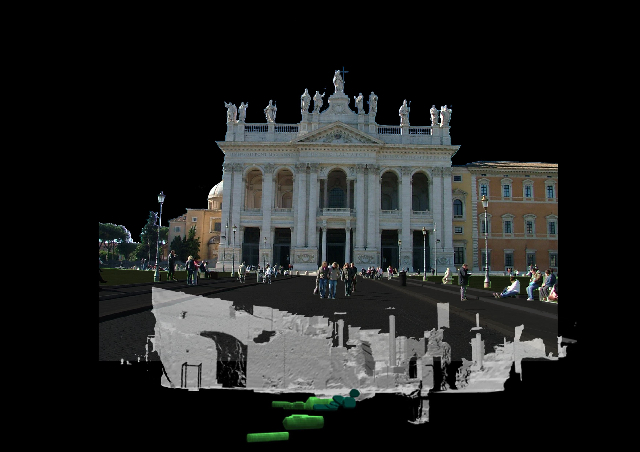
Module 3: Geophysical Surveys and Data Visualization
Tuesday, November 16
Geophysical surveys in archaeological research
We will learn about the practical application of geophysical surveys and how this has developed over the past three decades. Specific site examples will include the Catholme Ceremonial Complex, UK and Fort James in SD, US.
Site Examples / Multi-Method Applications Reading List
Lab 10: Data interpretation
Tuesday, November 23
Geophysical surveys and their ‘place’ in global archaeology
Geophysical surveys are employed through various research institutes, government agencies, and independent contractors. We will discuss today’s utilization of geophysical surveys around the world.
Presentation and discussion of interpreted archaeological features from geophysical surveys.
A draft of the final geophysical survey site report is due.
Field notebooks due for review.
KVAMME, K. 2001. Archaeological prospection in fortified Great Plains villages: new insights through data fusion, visualization, and testing, in M. Doneus, A. Eder-Hinterleitner and W. Neubauer (eds.). Archaeological Prospection: 4th International Conference on Archaeological Prospection. Austrian Academy of Sciences Press, Vienna: 141–143.
JOHNSON, J. (ed.) 2006. Chapters 2 & 3 from Remote Sensing in Archaeology: An Explicitly North American Perspective. University of Alabama Press.
The English Heritage Geophysical survey Database
Tuesday, November 30
Current and Future Developments in Archaeological Geophysics
Geophysical survey, data processing, and visualization tools are constantly evolving. We will look at the current state of survey kit and explore potential future developments
Tour and presentation of the Computing Graphics Group and SHAPE Lab (tentative).
KVAMME, K. 2006. Integrating Multidimensional Geophysical Data. Archaeological Prospection 13:57-72.
Powesland 2007
Buteaux et. al. 2000
CARDARELLI, E., A. GODIO, G. MORELLI, L, SAMBUELLI, G. SANTARATO & L. SOCCO. 2002. Integrated geophysical surveys to investigate the Scarsella vault of St. John’s Baptistery Florence. The Leading Edge, May 2002: 467-470.
WATTERS, M. 2007. New Methods for Archaeo-Geophysical Data Visualization. Unpublished Ph.D. thesis. Institute of Archaeology and Antiquity, Department of Earth Sciences, University of Birmingham, UK.
Lab 12: Final preparation of materials for presentation and public outreach.
Tuesday, December 7
Presentation of final project to Joukowsky Institute faculty and students
The conclusions of the class geophysical surveys, processing methods, and interpretations will be presented to the Joukowsky Institute.
Field Notebooks are due.
Final geophysical survey site report due.
Home | Announcements | Course Requirements | Weekly Assignments | Readings | Lectures | Discussion/Comments | Lab Assignments | Resources
