MAPs to encourage settlement |
||||
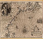 |
30. “New England.” In: John Smith. A description of NewEngland. London, 1616, and in: The generall historie of Virginia, New=England, and the Summer Isles. London, 1631. In 1614 the Plymouth Company sent John Smith on a reconnaissance voyage along the coast of what was then called northern Virginia. One of his directives was to scout sites for future plantations. Based upon his explorations Smith drew the map shown here, which was first published in 1616. In order to “domesticate” the land and make it more appealing to potential investors and settlers, Smith replaced the native place names with English ones. Only three of Smith’s names remain in the same place on the landscape today. Plymouth and Cape Ann in Massachusetts, and Cape Elizabeth in Maine. In fact, Smith took as much liberty with his own appearance as he did with native place names. As this popular map was reissued over the years, Smith’s image altered as well. State 4 of the plate is on the left; state 7 (with Smith in full glory) is on the right. As time went on, Smith developed a fine head of hair, sported a more luxurious beard, and showed himself off in fancier clothes. |
|||
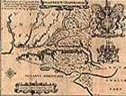 |
31. “Novae Terrae.” In: A relation of Maryland. [London], 1635. The first group of about 150 settlers—gentlemen adventurers, Jesuit priests, and ordinary people to work the land—sailed to Lord Baltimore’s Maryland in 1632. Although the colony seemed to be off to a good start, the proprietor realized that regular infusions of money, settlers, and supplies would be required to keep his investment viable. As soon as he received word by return ship that the colonists had arrived safely in Maryland and had begun to establish themselves, Baltimore kept up the momentum by publishing a second promotional tract. This contained the first printed map of Maryland so that people could visualize the advantages of the new settlement. |
|||
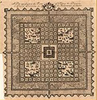 |
32. “A plan representing the form of settling the districts, or county divisioins in the Margravate of Azilia.” In: Robert Mountgomery. A discourse concerning the design’d establishment of a new colony to the south of Carolina. London, 1717. The English colonies were often exposed to hostile action, not only from the French and their Native American allies to the west and north, but also from the Spanish and their allies to the south. Sir Robert Mountgomery, an English aristocrat, proposed a buffer colony in the area that was to become Georgia. He called it the “Margravate of Azilia,” Azilia was planned as an ideal European “fortress” community, designed to integrate rural and urban activities. At the center was the Margrave’s residence, with four large deer parks and a “green belt” that separated the country from the settled area. For security, a continuous line of fortifications was proposed, instead of isolated forts. The settlement never progressed beyond the planning stage, perhaps because potential settlers didn’t see that being a “buffer” was a positive reason to emigrate to the New World. | |||
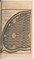 |
33.“Map of the State of Kentucky. Plan of Franklinville.” In: William Winterbotham. An historical, geographical, commercial, and philosophical view of the United States. London, 1794. vol. 4. | |||
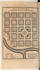 |
34. "Plan of Lystra in Nelson County, Kentucky," . In: William Winterbotham (see above). A group of speculators, probably English, promoted land sales in central Kentucky for the proposed towns of Lystra, Franklinville, and Ohiopiomingo. The chief publicist for the venture was William Winterbotham, author of an ambitious four-volume general history of North America. Winterbotham’s description of the United States may have been accurate, but his primary interest emerged in his description of Kentucky, which bordered on the lyrical (and the only town plans in this work were those of his proposed Kentucky settlements). Winterbotham’s prose may have brought these Kentucky towns alive for his readers, but Lystra, Franklinville, and Ohiopiomingo never existed, except on paper. |
|||
| Exhibition prepared by susan danforth. on view in the reading room from January 27 to april 23, 2010 |