


| Lina del Castillo: Jeannette D. Black Memorial Fellow, 2010-2011 Embellishments and Erasures: Placing Basque Merchant Power in Cruz Cano's Map of South America |
 |
|||
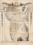
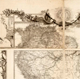
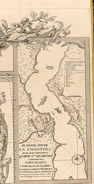
Cruz Cano y Olmedilla’s America Meridional, first printed in 1775, is indeed a monumental map, as Thomas Smith observed in 1966. 1. The scale is roughly 1:4,000,000 and when mounted, the eight printed sheets together measure about 6x8 feet. Through a careful comparison of available copies, including the one held at the John Carter Brown Library, Smith established that the map’s copper plates underwent three revisions from 1775-1802 resulting in four distinct editions. The changes extended Spanish claims while de-emphasizing Portuguese presence in contested territories in South America. According to Smith, the Spanish government commissioned the map from Cruz Cano but successfully withheld it from public circulation during sensitive boundary negotiations between the two empires. The map’s limited circulation makes this interpretation all the more persuasive. And yet, attention to the images that did not change on any of these editions -- the embellishments surrounding the topographic image of South America -- allows for a better understanding of the interests embedded in the map that Smith and others have tended to overlook. 2. These images can help us better understand the meaning of all four of the 1775 map editions, and why a 1799 re-engraving of the Cruz Cano erased them. |
|
|||
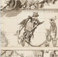
| The embellishments of this map, or “paramap” in line with Denis Wood and Jon Fels. 3. are both complex and revealing. They include references to the southern hemisphere’s botanical bounty (i.e., pineapples and passion flowers), a sun emblazoned with a bi-cephalous eagle and the pillars of Hercules and two spheres uniting emblems of Castile and Leon by the neck chain of the Order of the Golden Fleece. An anchor chain cascades down along the contours of eastern South America on angel’s wings, connecting the coats of arms of some (but not all) of South Americás most important cities. The lowest hanging of these is peculiar; instead of a city, it honors the Consulado de Lima, or Lima’s merchant guild. A bust to the left of this curious coat of arms honors Columbus’ gift of a New World to Castile and Leon. Female allegories for Spanish Fortitude, Blind Catholic Faith, and an Indian America offer their foundational support below the map’s title. |
 |
|||
| While the image of the sun emblazoned with the two-headed eagle and Pillars of Hercules confirms the map as a Bourbon project, Cruz Cano’s use of other images represents much more than the geopolitical interests of an absolutist dynasty. The presence of the Consulado de Lima amidst the urban heraldry indicates that the map also represented powerful merchant interests. Cruz Cano himself was an honored member of the Sociedad Bascongada de los Amigos del País. Accordingly, the map reflects the geopolitical commercial interests of Basque merchant guilds. Two inset maps, one of Lima’s port of Callao and the other of the newly founded city at Angostura in the Orinoco, offer a hemispheric commercial vision that claims control over the riches of the Andean Pacific and seeks royal support to discipline contrabandists in the Caribbean. The absence of Potosi and Buenos Aires from the urban heraldry suggests these particular merchants less interested in Upper Peru and the River Plate. |
 |
|||
Explaining the erasure of these embellishments from the 1799 re-engraving requires a little historical context. Thomas Jefferson sent his third edition of America Meridional to London via the United States diplomatic corps for re-engraving late in 1786. 4.Spain’s refusal to allow wider dissemination of this map, postponed the project. 5. By the 1790s, Spain had allied with France against Great Britain and the United States, changing the geopolitical playing field. In August 1798, the US diplomatic corps in London charged pro-independence Spanish American patriot Francisco Miranda with overseeing British mapmaker William Faden’s re-engraving. 6. Armed with this geographic vision of South America, Miranda called on British and US diplomats to “wreak the greatest possible injuries upon their enemies” by detaching from Spain an immense, wealthy and heavily populated dominion that could “by a counter stroke be turned to France’s advantage.” 7. It should therefore not come as a surprise that Faden’s 1799 printing omitted the portions of the paramap that heralded Spanish imperial control over South America. For not only did Britain and the United States covet this region; so, too, did pro-independence Spanish Americans like Miranda. |
 |
|||
1. Thomas Smith, “Cruz Cano’s Map of South America, Madrid, 1775: Its Creation, Adversities and Rehabilitation,” Imago Mundi, Vol. 20 (1966), pp. 49-78. The map’s full title reads: “Mapa geográfico de América Meridional, dispuesto y gravado por D. Juan de la Cruz Cano y Olmedilla. Geógrafo pensdo de S. M. individuo de la Rl Academia de Sn Fernando, y de la Sociedad Bascongada de los Amigos del País; teniendo presentes varios Mapas y noticias originales con arreglo a Observaciones astronómicas, Ano de 1775.” 3. Denis Wood and John Fels, The Natures of Maps: Cartographic Constructions of the Natural World (Chicago: Chicago UP, 2008). 4. Smith, “Cruz Cano’s Map of South America,” p. 66. |
||||