


Jack Crowley: JCBL Fellow, 1969-1970 and 1985-1986; Mellon Post-Doctoral, 2001-2002 Where was the British Empire? |
 |
|||
Where was the British Empire? In my more facetious moments, I think: mostly in the minds of post-colonial historians identifying ourselves as the New Imperial History - with our assignment of hegemonic imperial functions to butterfly collections, Christmas pantomimes, and even landscape art. And then I think: Surely more spatial and material precision is available from cartographic resources, such as those with which the JCB abounds. |
||||
Early modern mapmakers tacitly acknowledged that neither "New England" nor "New Britain" referred comprehensively to English/British domains in the Americas, in contrast to the ways that "Nueva España" and "Nouvelle France" identified Spain's and France's most important colonial territories. "New England" referred, well, to New England - that is to say, the English colonies south of the Saint Lawrence, east of the Hudson, and west of Acadia. "New Britain," referred to the god-forsaken lands east of Hudson's Bay, where it enjoyed large type because there was nothing identifiably there. True, John Oldmixon's British Empire in America (1708) provided no comprehensive map of that empire, but a dozen or so contemporaneous English/British maps used terms such as "English Empire," "English/British Dominions," and "English/British Plantations" to locate the territories of greater Britain. |
||||
By no coincidence, the John Carter Brown Library holds the strongest early cartographic definition of the English/British empire overseas, namely the Blathwayt Atlas. Forty-two years ago the Library published a superb facsimile edition of the Atlas's forty-eight printed and manuscript maps, most of them collected by William Blathwayt, Secretary to the Lords of Trade and Plantations, for purposes of colonial policy and administration. These maps ranged to supra-Atlantic and/or non-English places like Canada, Chile, Surinam, Brazil, Paraguay, and Bombay, but they concentrated "on English plantations in America," both regionally and individually. |
 |
|||
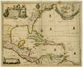
| The Atlas's crucial map for integrating English plantations spatially was Robert Morden and William Berry's 1673 New Map of the English Plantations in America. Both Continent and Ilands. It had one shortcoming that has not, to my knowledge, been pointed out before: it did not identify which of the various places indicated on the map were the English Plantations. (Go ahead: prove me wrong with Luna Imaging's zoom feature.) As a work of reference it only made sense to people who already knew the answers. Color-coding didn't help: yellow, green, and pink were used interchangeably for French and Spanish as well as English colonies. The map was more likely to confuse than to focus territorial fantasies of empire. | ||||
If I were to editorialize on Morden and Berry's silence about what they claimed to say, I would suggest that present-day Anglo-American historiography uses "Empire" too casually: It's usually a metaphor that refers to practically any British involvement overseas. Eighteenth-century writers were more sparing and geographically specific in references to Empire: they used "Colonies" and "Plantations" at least ten times as often as "Empire" when referring to British overseas interests. After all, the only institution dealing comprehensively with the colonies was the Board of Trade and Plantations, not the Board of Trade and Empire. |
||||