


Karl Offen: NEH Fellow, 2009-2010 Isthmus designs |
 |
|||
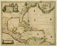
Assessing the importance of any map involves knowing something about why it was made and who saw it. Fortunately, we can answer both these questions for Robert Morden and William Berry’s “A New Map of the English Plantations in America” (Map 1). 1. Printed as a stand alone by the well-known London map makers and publishers in 1673, the map was one of 48 bound together into the so-called Blathwayt Atlas—named after William Blathwayt, secretary to the Lords of Trade and Plantations—and acquired by the JCBL in 1911. 2. Assembled between 1678 and 1683, the 35 print and 13 manuscript maps served as reference material for the newly reorganized Committee of the Lords of Trade and Plantations. 3. |
Map 1 |
|||
According to Jeannette Black, former Curator of Maps at the JCBL, “A New Map” was one of the earliest to show all the English-American colonies from Hudson Bay to Guiana. 4. It is also among the first overtly imperial maps of the English empire. The map is centered around the newly acquired island of Jamaica—whose significance is further emphasized by four additional maps in the Blathwayt Atlas. Three of the four legends on “A New Map” hint at how Jamaica’s strategic location in the western Caribbean basin might be leveraged to England’s advantage by underscoring the island’s proximity to Panama, English-speaking Indians in coastal Nicaragua, and its relationship with the English logwood colony at Laguna de Terminos (detail map1). 5. An advertisement in the London Gazette chose to promote the map by emphasizing “the excellent scituation [sic] of the Isthmus of Panama for Trade to the East Indies.” 6. Indeed, I would argue that Jamaica’s proximity to a potential trans-Isthmian route is one of the map’s main objectives, much like an earlier locational map of Jamaica by Richard Blome (Map 2). 7. |
Detail: Map 1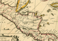 |
|||
But Panama was not the only or even the best place to cross the isthmus in the seventeenth century. The Desaguadero that drains Lake Nicaragua had been in the English cross-hairs since at least Thomas Gage’s 1648 survey of the West Indies, and, more importantly Cromwell’s Western Design. 8. By 1665 the Jamaican Governor, Sir Thomas Modyford, was informing officials in London about the escapades of three Captains who had sacked towns in Tabasco, Mexico, before heading up the Río San Juan (Desaguadero River, Detail: Map 1) with several Mosquito Indians to pillage Granada, Nicaragua. 9. After glorious accounts of their venture, Modyford ends his missive by pointing out that Granada lay only five leagues from the South Sea and that Nicaragua was located conveniently between Mexico and Peru. He added that the land could be easily taken with as few as 500 men and reached from Jamaica in 10 days sail. The final sentence reveals Modyford’s true intent: “if ever the reason of state at home require any attempt on the Spanish Indies, this is the properest place and most probable to lay a foundation for the conquest of the whole.” 10. |
Map 2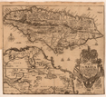 |
|||
“A New Map” conveys a similar message. That members of the Committee of the Lords of Trade and Plantations gazed upon this map while informing the colonial policy of Charles II reminds us that before Jamaica became the ‘Jewel of the British Crown’ it was a staging area, first for piracy and then for commercial dealings with the Spanish mainland and, it was hoped, the South Seas. Thanks to the JCBL and its acquisition of the Blathwayt Atlas we can contemplate how the Lords of Trade and Plantations viewed the English empire in America in the late seventeenth century and pondered its expansion. |
||||
1. (Map 1) Robert Morden and William Berry, “A New Map of the English Plantations in America Both Continent and Islands, Shewing Their True Situation or Distance from England or One with Another…,” London, [1673]. JCB Accession Number 8189. |
||||