


Jordana Dym: NEH Fellow, 2011-2012 Coastal Visions |
 |
|||
Nineteenth-century balloonists often described the land they passed over in cartographic terms as “a prodigious map spread out beneath [one’s] feet” or a “varying animated map.”1. For aviator Beryl Markham in 1942, “A map says to you… ‘I am the earth in the palm of your hand.’” 2. Twenty-first century map-readers generally share this aerial perspective of land-as-map or map-as-land. We expect maps both to roll out territory as if it were beneath us and to select it to fit within our view or grasp. Interestingly, this aerial and abstract cartographic view became commonplace in the age of sail. As I’ve found while looking at travel accounts at the JCB, at sea or sailing along the shore, this perspective was only half the cartographic formula. Travelers learned and copied from pilots who guided ships by knowing what was in front of as well as before or below them, which meant identifying particular shorelines and land formations. Navigators relied on both aerial-view sea charts and boat’s-eye coastal views. |
|
|||
The JCB collections chart the story of coastal views as map and illustration. It holds printed waggoners 3. and manuscript rutters 4., pilots’ manuals offering directions, sea-charts, plans of bays, and soundings to help pilots navigate and situate their ships along shore (and their predecessors, portolan charts which offered a visual coastal itinerary). A typical early modern sea-chart in the first English-language waggoner, The Mariner’s Mirrour (1588), shows an aerial view of a stretch of English coast; a compass rose orients navigators and water soundings indicate safe and unsafe passages. This linear perspective, as Ken Hills argued, delivers a “unified field of vision to the eye of the beholder [allowing] humans [to] trace a path to the place where they may become the measure of things.” 5. But what about when the ship faced a shore? To serve pilots at sea, each chart also includes inset coastal profiles as seen at sea level, a safe distance from shore. Each view annotates the vertical silhouette of coastline with a brief description of how to approach it and (if relevant) a natural or man-made landmark. |
 |
|||
| To a twenty-first century eye, the profiles seem generic possibly to the point of uselessness. Yet, scaled or labeled to provide context, coastal views conveyed necessary information to pilots and remained staple elements in navigation manuals and sea-charts well into the nineteenth century. 6.
|
||||
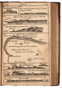
Coastal views also brought nautical perspectives to landlubbers. Merchants and policy-makers owned rutters and waggoners, but armchair adventure seekers devoured travel accounts, bestsellers of the early modern period and a staple in JCB collections. Readers found lively descriptions of marine exploits by pirates, traders and explorers who used coastal views to illustrate nautical observations, whether as separate “tables,” as in the Mariners’ Mirrour, or fused with charts. A case in point is the account by adventurer William Dampier [1651-1715] of A Voyage to New Holland &c in the year 1699(London, 1703) with three pages of coastal views of Brazil. Dampier’s profiles for a popular audience were the work of a serious navigator. Non-specialists consulting his traditional coastal “sights” (Figures 1-4, 6-8) learned not only an angle of approach but Dampier’s distance from shore when viewing the terrain. |
 |
|||
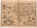
| They also experienced a kind of double vision when looking at a combination chart and profile of Todos Los Santos bay, which imposed coastal profiles of the Bahia shoreline on the aerial view of the entire bay (Figure No. 5). 7. The text offered directions on how to navigate this double perspective. Readers should “[s]ee a prospect of the Harbour and the Town as it appeared to us as we lay at anchor…right against the town, at the outer part of the harbor…within 150 yards of a small Fort that stands on a rock half a mile from the shore” (p. 49). Dampier’s directions worked best for those fortunate enough to consult the English original. Coastal views copied in Dutch (1704), French (1705), and German (1707) editions of this international blockbuster attempted with diminishing accuracy to replicate the plates (compare the 1703 English to the 1707 German edition), creating a different kind of double vision. Perhaps not surprisingly, as specialized coastal perspective (like other maps of exploration) worked their way into popular visual culture, authorial precision suffered. |  |
|||
1. Alison Byerly, “‘A Prodigious Map beneath his Feet’: Virtual Travel and the Panoramic Perspective,” Nineteenth-Century Contexts 29.2-3 (2007), cites from pp.159 and 160. Thanks to Matthew Edney for this reference. |
||||