


Matthew H. edney: Jeannette D. Black Memorial Fellow, 2001-2002 The Lessons of a Generic Map: |
 |
|||
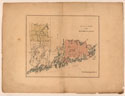
Although the JCB’s cartographic collections are generally associated with the history of exploration and discovery, they are also crucial for the study of imperial consolidation and management. For example, the Plan of Part of the District of Main 1. is instantly recognizable as one of that class of printed maps made to promote tracts of frontier land to would-be purchasers. It exemplifies the now commonplace argument that all maps, even the most plain and factual, are propagandistic. (Maps don’t show what the world is, they show what the world ought to be.) However, this argument places the rhetorical burden on the map itself, on its content and its look. But, as the history of the Plan suggests, this is not necessarily appropriate. |
|
|||
The Plan depicts a series of patents and townships at an early stage in the territorial division of what is now the state of Maine, then the Eastern District of Massachusetts; the coloring highlights two tracts of land, each of one million acres (ca. 40,500 ha), acquired by the Philadelphia magnate William Bingham (1752-1804) in January 1793. (Note also that these regions possess none of the ambiguity of caused by the overlapping of the other patents.) Circumstantial evidence suggests that it is based on maps compiled by the Philadelphia draftsman Charles de Krafft (fl. 1783-1800, d.1804) from the maps and surveys of the Boston mathematical practitioner, Osgood Carleton (1742-1816). 2. Although bibliographers have assumed that the Plan was published in Boston, 3. it was engraved with much greater precision and elegance than any American-made maps of the period. 4. The look of the map is borne out in the archival record. Bingham’s agent in London, Major William Jackson, actually commissioned the engraving from the workshop of William Faden (1749-1836), geographer to the king, who charged twenty guineas [today, ca. £2,000] to make “a handsome exhibit of the land.” The first impressions were pulled in late October 1793. 5. Jackson intended the map to accompany the pamphlet describing the Maine lands that he had had printed in June 1793, directly before he left Philadelphia for London.6. |
||||
No more than a handful of impressions of the Plan are known in libraries. Given that library collections are formed mostly from printed works sold through the marketplace, together with the lack of an imprint on the Plan, we can conclude that it was not “published.”7. There are, however, at least ten more impressions in the various archives related to Bingham and his associates. The three preserved in the Baring Archive, in London, were all annotated as Sir Francis Baring (1740-1810) and his son Alexander (1774-1848) sought to understand the geographical position and economic potential of the region; they eventually bought the eastern tract (colored red on the Plan). We can conclude that William Jackson distributed the Plan personally within a suite of media (print, manuscript, and speech). As a well-executed map, it functioned as a document of reference and record, as a fixed and stable text that would enable negotiations, restrain their complexity, and transmit institutional memory. Its persuasiveness depended less on its content and look and more on the personal and business networks within which it circulated and was actively read and used. |
||||
1. John Carter Brown Library Cabinet Cb793 2.1. Drawn at a scale of about one inch to twelve miles within a neatline measuring 34.5cm x 40.5cm. 2. “Mathematical practitioners” were, generically, early modern individuals who worked across the mathematical pursuits of surveying, mapping, navigation, teaching, and engineering. David Bosse, “Osgood Carleton, Mathematical Practitioner of Boston,” Proceedings of the Massachusetts Historical Society 107 (1995): 141-64; Matthew H. Edney, “Mathematical Cosmography and the Social Ideology of British Cartography, 1780-1820,” Imago Mundi 46 (1994): 101-16. 6. [William Jackson], A Description of the Situation, Climate, Soil, and Productions of Certain Tracts of Land in the District of Maine and Commonwealth of Massachusetts ([Philadelphia]: [printed by Zachariah Paulson], [1793]); Evans 25720; ESTC W37913. 7. See Matthew H. Edney, “Printed but Not Published: Limited-Circulation Maps of Territorial Disputes in Eighteenth-Century New England,” in Mappæ Antiquæ: Liber Amicorum Günter Schilder, ed. Paula van Gestel-van het Schip et al. (’t Goy-Houten, Neth.: HES & De Graaf Publishers, 2007), 147-58. |
||||