


Carla Lois: Jeannette D. Black Memorial Fellow, 2006-2007 Quarta Pars, island or continent? Cartographic and other graphic devices for a conceptual history |
 |
|||
One of the debates prompted by the European discovery of America concerned the geographical status of the New World. Humanist scholars soon concluded that the New World was the Fourth Part of the World, but they encountered some difficulties in trying to provide a conceptual framework to organize information about the newly discovered lands or extra-Ptolemaic regions. Recent research has shown that, in spite of pretty stable classification of the parts of the world (Europe, Africa, Asia, and later, America), the shaping of each one was a complex process. Both the basic fourfold continental scheme (as Lewis and Wigen suggested) and the geographic identity of each part required some adjustments to the traditional concept of a continent. |
|
|||
The beginning of that process coincided with another intellectual transition in the Western approach to earth sciences: during the first half of the sixteenth century, geography and cosmography developed increasing specialization in the objects that practitioners studied and methods they applied, as well as in the concepts articulated and the representations used to portray their subjects. Cosmographies continued to specialize in the astronomical and mathematical aspects of the terrestrial sphere (still the Earth, as a celestial body, considered in relation to the skies), whereas geographies tended to represent and describe the terrestrial surface. In that context, the standard classification (mentioned in many cosmographies and other scientific books) for landmasses consisted of four categories: island, isthmus, peninsula and continent (see Map 1). |
Map 1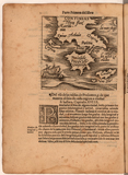 |
|||
| But there are other possibilities… America challenged this conceptual framework in several ways. The first obvious question, namely, whether the New World was an island or a continent, has not had a simple answer. In early modern geography and cosmography texts, America sometimes appeared as an example of a continent (see Map 2) or as an island, and even, in some cases, was totally absent. At the end, the preoccupation with finding a place for America on the geography of the world triggered a revised understanding of the idea of a continent. Starting from a negative definition (“a continent is everything that is not an island, isthmus or peninsula”), new essays succeeded in providing an equivalent geographical status for the four parts of the world by selecting empirical features of the parts to redefine the term “continent.” Beginning by exploring cosmographic discourses, one can quite easily follow the traces of these subtle conceptual changes, without necessarily understanding the participation of the New World in that sharp conceptual mutation.
|
Map 2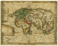 |
|||
The broad range of materials at the JCB—especially scientific books, maps, histories, and travel accounts—made possible a different approach for a conceptual history of this subject: images of various types and in various media, contrasted with definitions, verbal descriptions and theoretical arguments, are, much more than simple illustrations, devices that interact with texts and allow us better to follow the intricate process of the conceptual redefinition of “continent” as an effort to provide an equivalent geographical status for the Fourth Part of the World. By comparing the shapes ascribed to the New World on world maps with contemporary illustrations devoted to those four categories of landmasses, their historical evolution during the sixteenth century, and also with the place given to the New World in geographical books, and in the above-mentioned geographical classification of landmasses, the conceptual history of the idea of the continent reveals the importance of considering the visual culture in which maps were produced and circulated. |
||||
1. Martin Lewis and Kären Rigen (1997), The Myth of Continents: A Critique of Metageography. University of California Press, Berkeley, Los Angeles, London. Also Christian Grataloup, L’invention des continents. (Paris: Larousse, 2009). |
||||