


| Paul Mapp: NEH and Mellon Post-Doctoral Fellow, 2005-2006 What Maps From the John Carter Brown Library Meant for Me: Making the Unknown Accessible |
 |
|||
I wanted to include maps from the John Carter Brown Library in The Elusive West and the Contest for Empire, 1713-1763, in part, as a kindness to the book’s readers. The library’s maps create an elegant frame for a perplexing subject. They break up lines of reason with figures for reflection. They transform a forbidding manuscript into an inviting volume. |
|
|||
More fundamentally, I wanted the maps because they aid the author. They make abstract arguments believable by making their grounds visible. The task of Elusive West was to show that large parts of the North American West remained largely unknown to outsiders, to account for this geographic ignorance, and to demonstrate its consequences for the empires trying to dominate the continent. A certain amount of this showing, explaining, and demonstrating could be accomplished through the unfolding of arguments and interpreting of texts, but not enough to make the implications of eighteenth-century geographic uncertainty intuitive for modern audiences. Blessed or cursed as we are with a surfeit of information, geographic and otherwise, it’s difficult to imagine the North America of the 1700s as geographically benighted eighteenth-century people did, especially on the basis of verbal evidence alone. The words in old documents suggest, but do not convey. |
||||
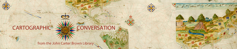
John Carter Brown Library maps suggest and convey. They show eighteenth-century cartographers’ geographic familiarity giving way to speculation, and they display products of that speculation. To take one example from Elusive West, on Dutch cartographer Nicolaes van Frankendaal’s 1750 map of Hudson Bay and the regions around it, the bay itself and the lands south and east of it are not so different from what one might see from a satellite today; to the west, on the other hand, lies not only the customary signifier of the undiscovered, the cartouche, but also “parties inconnues” and a collection of lakes, rivers, and Pacific coasts very different from what one would find if reconnoitering the area in 2012. The reader can see at a glance the contours of eighteenth-century geographic uncertainty and the contents with which eighteenth-century people filled the geographic unknown. |
 |
|||
These contents invite discussion. Frankendaal’s map leaves space for a Pacific entrance of the long-sought Northwest Passage; another map from Elusive West, German scholar and Siberia-Pacific explorer Gerhard Friedrich Müller’s 1754 view of the North Pacific and its adjacent regions, includes representations of how such an entrance might look. Features such as these immediately raise questions such as why particular items appeared in these images and how seriously eighteenth-century people took them. Did 1750s statesmen conduct affairs with an eye to the possibility that Hudson Bay or the Missouri River were gateways to the South Sea? Maps alone, even maps as evocative as Frankendaal’s and Müller’s, can’t answer these types of questions, but they can provide a starting point for the kinds of textual investigation that might. The John Carter Brown Library maps illustrating Elusive West help launch and justify its efforts. |
||||
| Frankendaal’s differing portrayal of eastern and western American lands and waters points to another valuable feature of the John Carter Brown Library’s maps: contrast. To understand why the elusive West of the book’s title remained so difficult for so many to grasp, I set European achievements in mapping some parts of the world alongside the difficulties of charting western North America. I talked not just about New Mexican expedition leader Pedro de Villasur and French-Canadian explorer Pierre Gaultier de Varennes et de La Vérendrye in the western North America of the 1700s, but also sixteenth-century Spain’s encounters with Mexico and Peru, and eighteenth-century French cartographers’ work in Siberia and China. Cartographic contrasts invite such comparative treatment. The difference on Müller’s 1754 map between a densely detailed northeast Asia and a nearly empty northwest America, and on Spanish cartographer Tomás López de Vargas Machuca’s c. 1783 map between a full South and Central America and a sparse western North America opens the issue of why the one region resisted the comprehension by outlanders that other areas allowed. The maps don’t say why, but they suggest the value of Elusive West’s trying to do so. |  |
|||
By showing that eighteenth-century people were thinking about the North American Far West, were filling its unknown reaches with the products of their imagination, were frustrated in their efforts to understand the region, John Carter Brown Library maps point to the need for an examination of eighteenth-century notions of western American geography. More subtly, by making antiquated geographic ideas available to the senses, the library’s maps make arguments about the importance of such ideas credible to the mind. |
||||